All Activity
- Past hour
-

E PA/NJ/DE Winter 2025-26 Obs/Discussion
MJO812 replied to LVblizzard's topic in Philadelphia Region
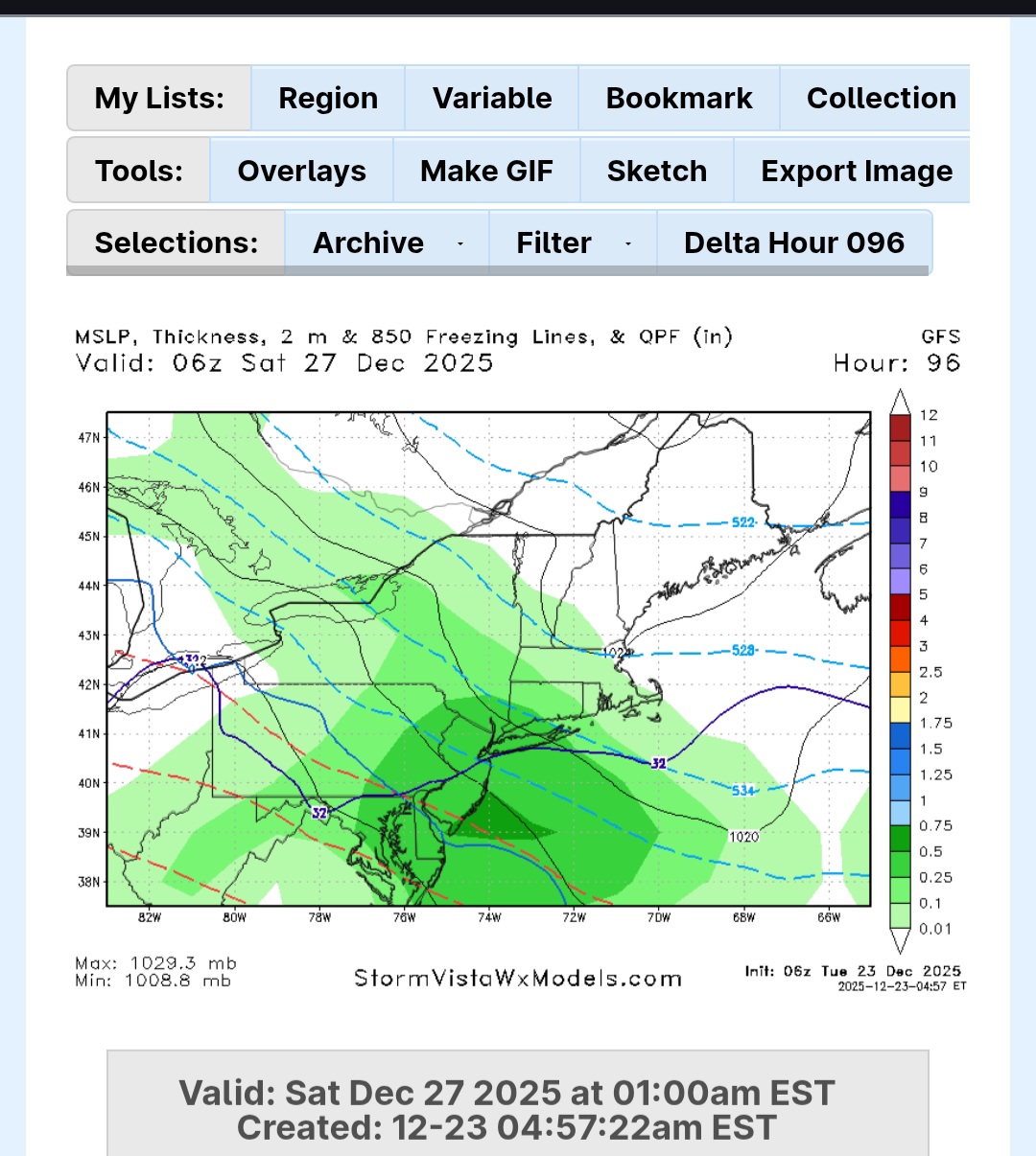
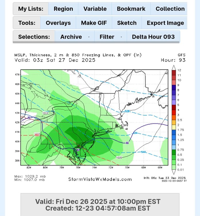
Gfs is a Philly bullseye -

E PA/NJ/DE Winter 2025-26 Obs/Discussion
Duca892 replied to LVblizzard's topic in Philadelphia Region
Man that storm on Friday just looks like a snow to icy mix mess -
Gfs is a tick south and colder 6 plus for many

-
AI gfs
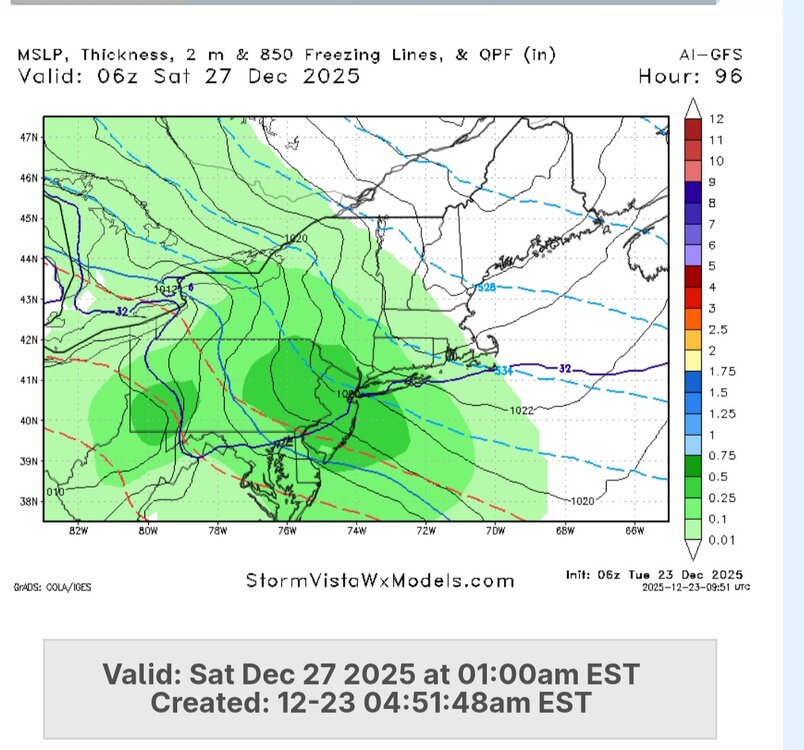
-

Central PA Winter 25/26 Discussion and Obs
mahantango#1 replied to MAG5035's topic in Upstate New York/Pennsylvania
34 here currently, don't see this sticking around long. -

Central PA Winter 25/26 Discussion and Obs
mitchnick replied to MAG5035's topic in Upstate New York/Pennsylvania
Started as decent snow around 4:30. Good luck up north of me. I'm sure mine will be washed away....but not yet! -
Started as some decent snow this morning before being washed away shortly. Lol
- Today
-
Possibly the northern mountains but at this time the cold front looks dry. Unless your into skiing then somewhere like Beech mountain. But at this time the models aren't showing any winter weather around New Years.
-

Winter 2025-26 Medium/Long Range Discussion
TheNiño replied to michsnowfreak's topic in Lakes/Ohio Valley
Welp. See y’all in a few weeks. -
You rang.
-

December 2025 regional war/obs/disco thread
WinterWolf replied to Torch Tiger's topic in New England
Thank you for the reasonable post. -

Winter cancelled/uncancelled banter 25/26
coastalplainsnowman replied to Rjay's topic in New York City Metro
I figure this is as safe a place as any to post this. Hear me out.. was just watching Fox Weather for more than 3 minutes straight for the first time. I'll say this much - at 1AM they were covering - wait for it - weather. Talking about the Dec 26/27th threat, naming each of the models, presenting what each is showing. Not taking itself too seriously. Beats the other late night weather options of When Tornadoes Attack or some such nonsense on TWC, or the Accuweather wall to wall equivalent of Local on the 8s interspersed with mattress commercials. Just saying - not the worst thing to have on the telly in the background. What's the saying? Don't @ me bro... -

December 2025 Short/Medium Range Forecast Thread
John1122 replied to John1122's topic in Tennessee Valley
I think we'd all take this, with single digit cold pressing in behind the second clipper. -

E PA/NJ/DE Winter 2025-26 Obs/Discussion
LVblizzard replied to LVblizzard's topic in Philadelphia Region
I don’t really trust globals on the snow/mix line. We’ll have to wait another day or two for the hi-res models to come into range. What does look certain is that this will be an all or mostly frozen event for most of us. WWA just issued for Lehigh/Northampton counties for this morning. NWS expects 1-2” around here. -

Central PA Winter 25/26 Discussion and Obs
Festus replied to MAG5035's topic in Upstate New York/Pennsylvania
Per Millersville archive, we received 3.5" on December 26, 1947. Geez, getting fringed even way back then. -
December 2025 Short/Medium Range Forecast Thread
John1122 replied to John1122's topic in Tennessee Valley
The Canadian is just full blown winter, snow, ice box cold before New Years and after. +PNA looks beginning to appear and downstream we win. Old fashioned clipper/Siberian express on there. -

E PA/NJ/DE Winter 2025-26 Obs/Discussion
RedSky replied to LVblizzard's topic in Philadelphia Region
Boxing day looks like snow quickly going to ice -
The Euro and AIFS both look great! Most of the snow falls from 7 pm Friday to 7 am Sat. Just about every model is on board, but we're still 4 days away and much can still change...but I like where we are right now.
-

Central PA Winter 25/26 Discussion and Obs
Jns2183 replied to MAG5035's topic in Upstate New York/Pennsylvania
I wouldn't expect anything more than CAD doing its thing. Snow, no; Ice, yes Sent from my SM-S731U using Tapatalk -
Its crazy enough it was 59 like that 3 in-and-outs, a 4th would be a hair raiser. I'm getting the largest flakes of the season, some 2.5" in size but I wasn't out in it. Its lasting too, 1 hr of large but 10 mins of the giants. I'm just above freezing and near the rain line.
-
You're not gonna believe this. Buda's normal high/low is 59/42. It's 11.47pm Texas time. We have light south winds from the Gulf of Mexico. The temperature is 68 degrees, with a dewpoint of 66, it is quite humid out. I will definitely need to run my car A/C while running deliveries tonight. We are gonna have early May normals for Christmas, and maybe even for New Years'.
-
E PA/NJ/DE Winter 2025-26 Obs/Discussion
LVblizzard replied to LVblizzard's topic in Philadelphia Region
It’s virga. 0z hi-res models are slightly more aggressive for tomorrow. HRRR has 1-3” around I-78. Hoping to wake up to steady snow in the morning. -
How do things look rolling forward in terms of precip? Absolutely brutal start to the snow season in much of the West.
-
“I’ll take the under on it being 70 degrees on Christmas” - me to Ji a week ago Forecasted high of 46 on Christmas and a chance of wintry mix the day after with a high of 37 So much for a torch. Models look to be converging on the idea of possible winter revival by 1/5.. but we’ll see how that all looks a few days from now. One thing is for sure - models are struggling past D10. Just have to be patient and see how things unfold this winter. Posting “weeklies” and 384hr OP runs every 6 hours is pointless. Save yourself the headache.
-

December 2025 regional war/obs/disco thread
weathafella replied to Torch Tiger's topic in New England
I bet euro comes sizably north tonight