All Activity
- Past hour
-

Central PA Spring 2026 Discussion/Obs Thread
paweather replied to Voyager's topic in Upstate New York/Pennsylvania
Hey everyone, I just wanted to check in to let you know I’m very sorry towards the way I acted to everyone earlier last year. I know I have no excuses but I’m going through a terrible health issue that will require a transplant and it stinks. If all of you are OK with it I’ll check in at times. The laughter and frustration we had during the years I’ll never forget. Thanks and have an enjoyable spring and summer may god bless everyone. paweather -

2026-2027 Strong/Super El Nino
Stormchaserchuck1 replied to Stormchaserchuck1's topic in Weather Forecasting and Discussion
MEI vs Nino 3.4 - Today
-
0z
-

Texas 2026 Discussion/Observations
Stx_Thunder replied to Stx_Thunder's topic in Central/Western States
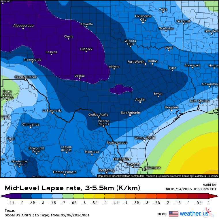
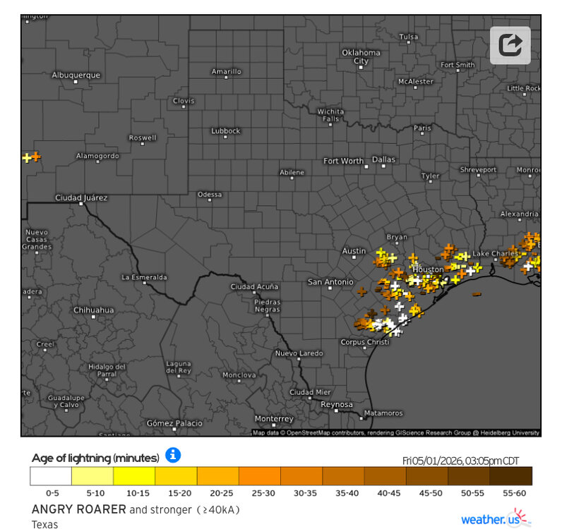
Aside from today's svr threat, things still look to remain convectively active through next week in the state, with at least a conditional svr risk later this week or weekend over the southern half. And more of the state again next week. Even if this week's front (does) manage to push south of the state, it does not look like it's going to be enough to actually shut off the thunder risk. Especially, a cutoff Low that looks to set up shop out west late this week. Not surprising being in May. But especially back in EN territory now already. There has also been a + PNA phase ongoing lately that likely also contributed to last week's bout of sig convective severe events in the state. Aside from the latter/early phase unit circle MJO. - - - Next week, what's most concerning to me right now is how steep ML Lapse Rates are forecast. Current projected values are bordering on crazy for (May) standards. Normally, no more than -7 to -8 range from what I've seen over the years in May. Steeper ML lapse rates in the state have easily been a notable trend (so far) this year. 'Definitely going to be LOTS of lightning in most cells no doubt, for sure if these kind of forecast values (-8 to -9 range) hold with ample CAPE and not much CIN likely to be in place again by mid-week.
-

Mountain West Discussion
mayjawintastawm replied to mayjawintastawm's topic in Central/Western States
A very saturated 1.8" at 11 PM here. Rates, indeed! Need some. -
Windy
-

Central PA Spring 2026 Discussion/Obs Thread
Ruin replied to Voyager's topic in Upstate New York/Pennsylvania
I did some stuff outback ground is pretty green and wet dug down a bit to plant a new tree in the back yard and moisture content was very high. the landscaping crew told me only to water it a little after planting since the ground lvl water table is high. So yeah we had a short period in april where we got way hotter then normal. but last 2 weeks aside from this tuesday we have been very cool to cold over night. 3 times last week I had frost on my car at 530-6am getting out of work. -
Heaviest snow of the event here west of 25 in Northglenn. Radar looks like some goods here for the next hour.
-
Texas 2026 Discussion/Observations
Stx_Thunder replied to Stx_Thunder's topic in Central/Western States
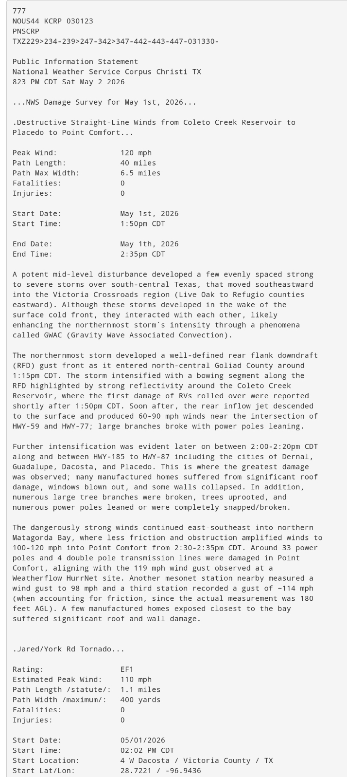
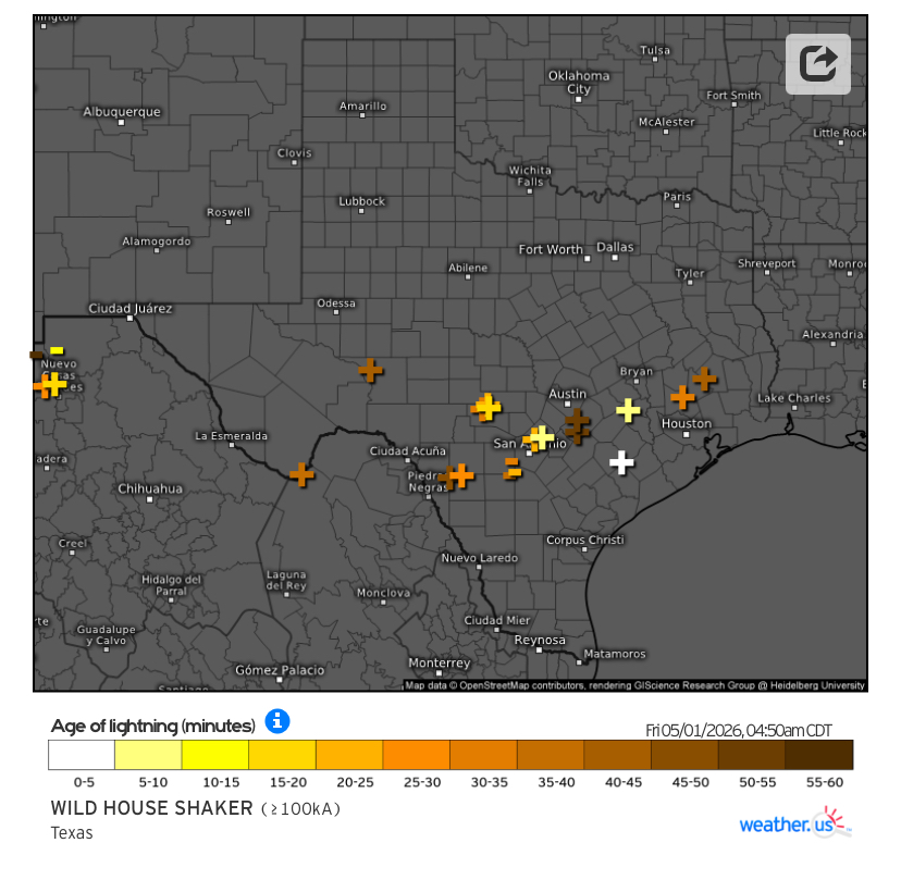
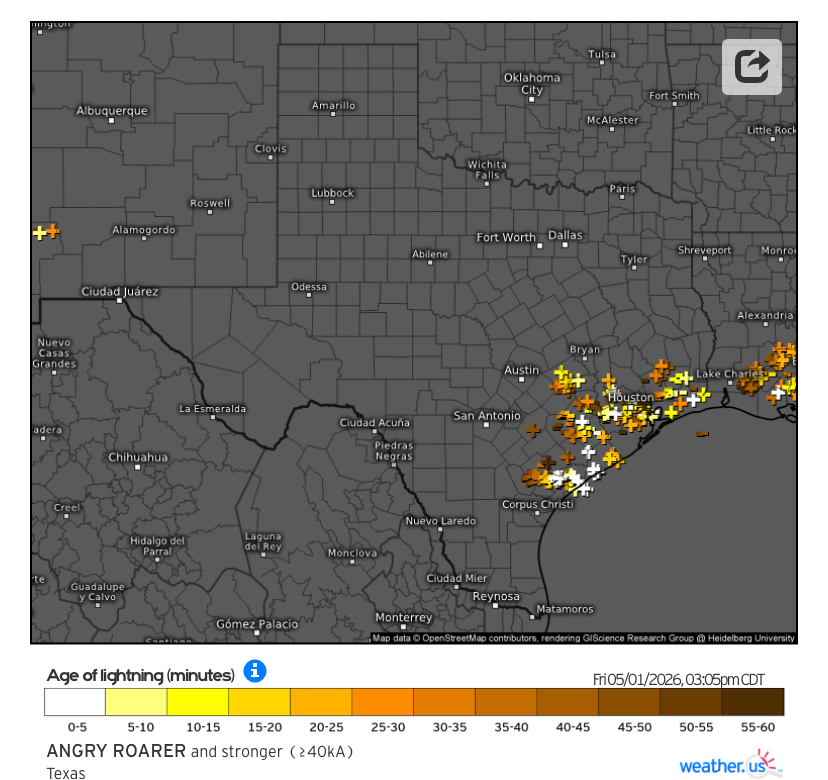
Extremely interesting convective factors that lead to a (major hurricane force) straight-line wind event last Friday, over the mid-coast region around Point Comfort near Matagorda Bay. In the Victoria area. That max. recorded wind gust was even stronger than the EF-1 tornado damage (110 mph) that was surveyed in Victoria county that same day. And from the same, quite large & intense thunder cluster that developed near SAT around midday and intensified heading east-southeast toward the mid-upper coast in the early afternoon. Both that system and several other clusters late Thursday night - early Friday traveling W - E along the I-10 corridor from Del Rio - Houston (behind sfc cold front), also had a good amount of powerful + CG lightning strikes.

-

2026 Mid-Atlantic Severe Storm General Discussion
high risk replied to Kmlwx's topic in Mid Atlantic
I think they're bored. But seriously, the shear is great, but as they noted, there just isn't any instability to work with. Unless that changes, the general thunder outlook is reasonable. -
Its snowing in Colorado tonight! Up to 12 inches!! https://coloradoweathercam.com/boulder-colorado-weather-cams/ Mammoth got 3 inches last night! I am The Jebman. I ALWAYS know where to find the snow! Even in May!
-
I had another enjoyable evening walk due to still pretty comfy dewpoints for early May. Third nice day in a row!
-

2026-2027 Strong/Super El Nino
so_whats_happening replied to Stormchaserchuck1's topic in Weather Forecasting and Discussion
Im sorry but that is just not true, look at 97/98 as the example right on the money. There is a key thing within the variables it is picking up on that is causing it to be lower versus ONI/RONI. This seemed to have switched up around 09/10 season onward. In fact you could even argue it was pretty darn close for the 15/16 super Nino.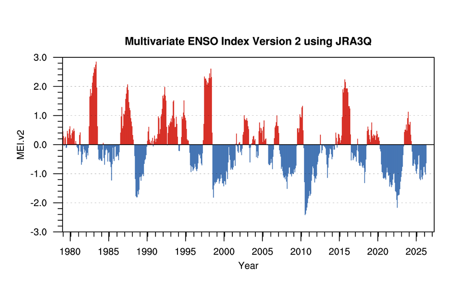
-
Pretty much exact same here. Just light snow past couple hours, very little additional accumulation. Gonna be all about rates the rest of the storm.
-
It popped up less than a week out unlike the more recent rug pulls.
-
radar for 8:21 mountain time
-
Mountain West Discussion
mayjawintastawm replied to mayjawintastawm's topic in Central/Western States
Changed here at 5 PM sharp, was real heavy for an hour, now much lighter. Catching its breath I guess. Accumulation is going to be hard to assess due to melting as it falls, but my white styrofoam box lid is ready and waiting. Maybe an inch and a half?? -
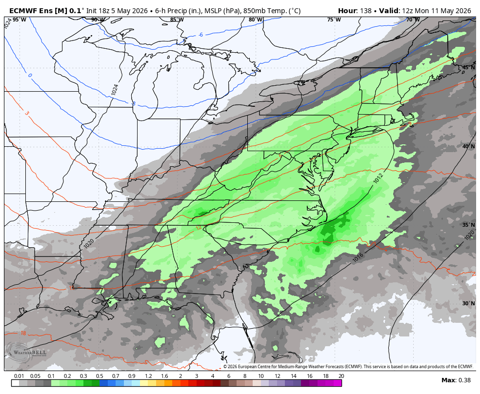
WB 18Z EPS. Rain still possible on Monday.
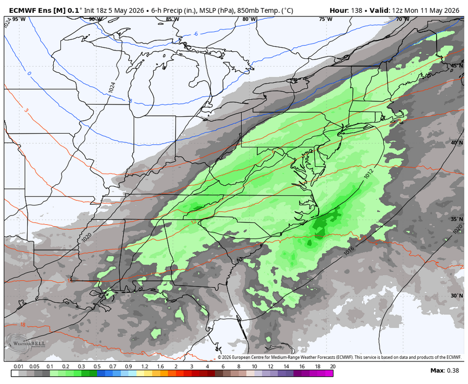
-
They’re terrible. And the manager is the worst part. He has no idea how to manage a bullpen. Frankly, I’d be way happier with Showalter.
-
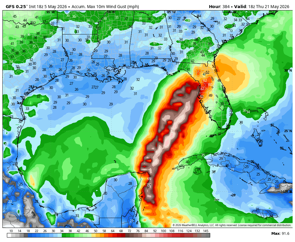
WB 18Z GFS at range. GOOFUS is off to an early start in the tropics.
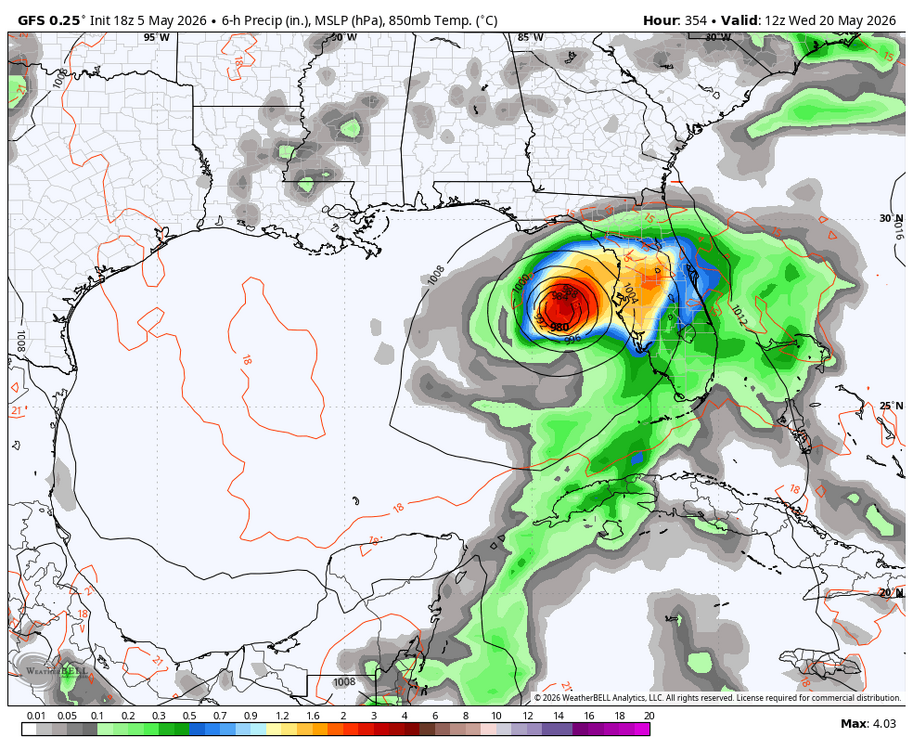
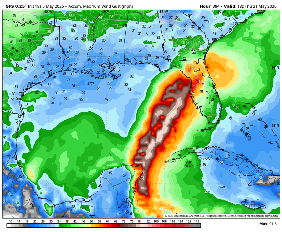
-
I’m pretty sure my lawn will be super-green next winter.
-
Saturday looks rainy. Sunday looks like it could be good though, warm for Mother’s Day at least.
-
A tad breezy out there tonite here
-
I mean in 22-23 the entire eastern seaboard got shafted and if the niño version of that is the setup we get...
-
This Os team might be worse than last years. Verdict still not out.