All Activity
- Past hour
-
 .18 and of course, I slept thru it.
 -
Looks like I'll be batting zero in the rain dept today while less than 3 miles from me they got .24 today.
-
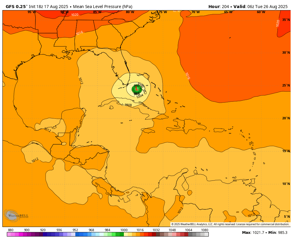
Mandatory Evacs beginning now thru Tuesday morning for Dare County. Will be expanded soon to include additional Islands / Counties I would imagine.
-
 Maybe a shower here if we’re lucky, the rest is collapsing as it heads over LI or staying over the city as usual.
 -

Occasional Thoughts on Climate Change
donsutherland1 replied to donsutherland1's topic in Climate Change
I've often noted that Phoenix's warmth is a combination of UHI and climate change. The scientific literature describes numerous impacts on the Southwest monsoon in a warmer climate, particularly a drier monsoon season, fewer rain events, and higher temperatures during monsoon season. This evolution is currently in its early stages. The outcome described in the literature won't happen all at once or uniformly. Phoenix deserves focused attention because it represents both an extreme case and an early signal of how climate change and aridification interact in the desert Southwest. Phoenix’s accelerated warming, even as UHI amplifies the impact of ongoing warming, makes it a valuable barometer of what other communities may face as aridification deepens across the state. -
Many probably will be . D1-D2. It’s been a common theme last 5-10 years
-
 Thunderstorms built to my WSW and just grazed my house with a drizzle. Really blew up just east of me and into NYC.
 -
Droughts in New England tend to be short lived. We will be complaining about excessive rainfall before long.
-
Some of us could be in moderate drought, heading into the autumn.
-
What a boring place this would be if every post was spot on accurate without questioning. Respectfully, why have Forum? ERIN wasn't a threat for landfall (given players in the field) but still worthy of the nuisances from formation to dissipation. A CAT5, strongest, fastest intensifying for the location and time of year.
-

Spring 2025 Med/Long Range Discussion
KakashiHatake2000 replied to John1122's topic in Tennessee Valley
check out nws morristowns afd a couple of news mets have leaked it already on facebook not sure about any where else on social media -
Quite the outflow at PWM
-
Looks like I got about .2” - so so welcomed.
-

Hurricane Erin: 125 MPH - 946mb - WNW @ 13
WxWatcher007 replied to BarryStantonGBP's topic in Tropical Headquarters
-
 this si crazy
 -
All snowy all the time
-
MoCo literally stealing HoCo's thunder
-
3k NAM says tomorrow is a midnight high with midday highs of upper 60s/low 70s. Euro is near 80/low 80s. GFS upper 70s, GGEM low 70s.
-
No, it's not. It's not the same at all. Although Bradley recorded whether the normal July, Bridgeport recorded drier than normal July. That was different from last year. No two years are exactly the same. Anyway. Still no clue what's going to happen this winter but after having multiple Winters below normal, it's bound to change
-
I had to go to Lancaster for camp Hill to be hit Sent from my SM-G970U1 using Tapatalk
-
The good news is, with all this dry weather we've been having as of late, hoping it'll bode well for our winter. Not being so dry. Last spring and summer were wet and by the time we went into rent to return much drier. So let's hope for the other direction
-

NEW DISTURBANCE: Central Tropical Atlantic (0/30)
GaWx replied to BarryStantonGBP's topic in Tropical Headquarters
Meanwhile, the lone highly threatening op. global model hangs onto it at Happy Hour:
-
Raaaaaaiiiiiiiiiiiiiiinnnnnnn!
-
I picked up .37” out of that. Line is still throwing off thunder on the back of it.
-
7 out of last 8 days here…it just seems normal


.thumb.png.4150b06c63a21f61052e47a612bf1818.png)