All Activity
- Past hour
-

Augdewst 2026: Summer's Last Stand
Sey-Mour Snow replied to Prismshine Productions's topic in New England
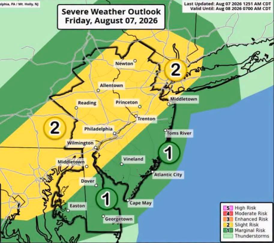
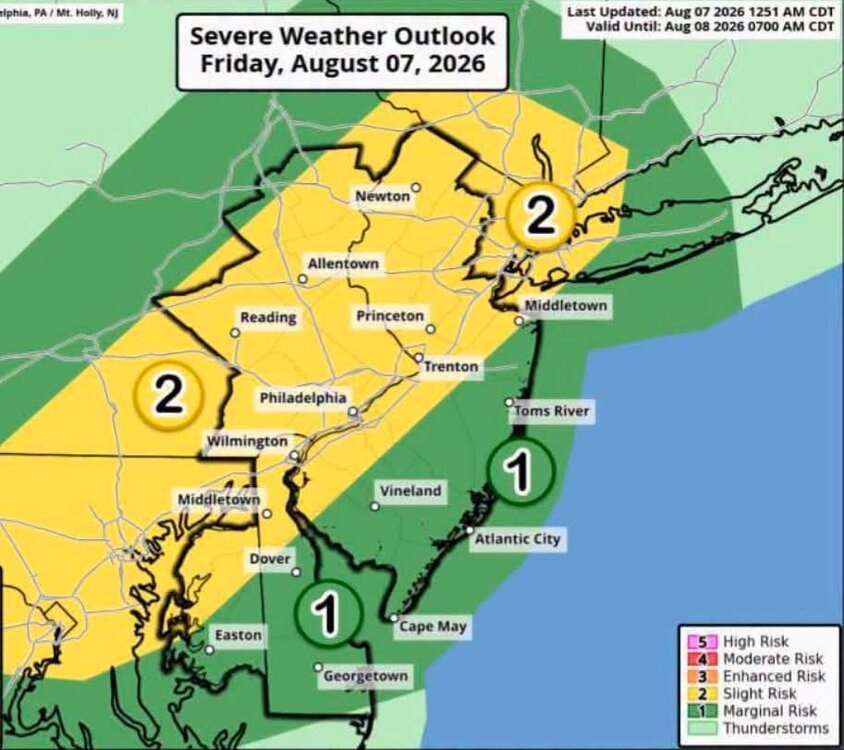
Suprisingly HRRR likes this area tonight for some trainers . I hope it stays west of East Haven, going to RI after summer baseball playoffs tonight, can't have those rescheduled for tomorrow and eat into my last summer getaway. -
Wouldn’t be surprised if we get a curveball cold month or two this winter. Ofc odds are def leaning towards mild and wet overall ala classic Nino and even just considering our recent trash winter climo regardless of ENSO conditions. However you can never discount a rando month or two where conditions set up perfectly on our side of the globe for cold/snow while Siberia and the oppo side torches.
-
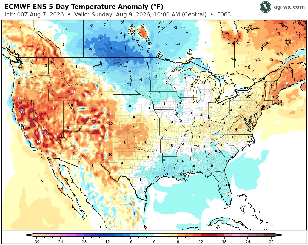
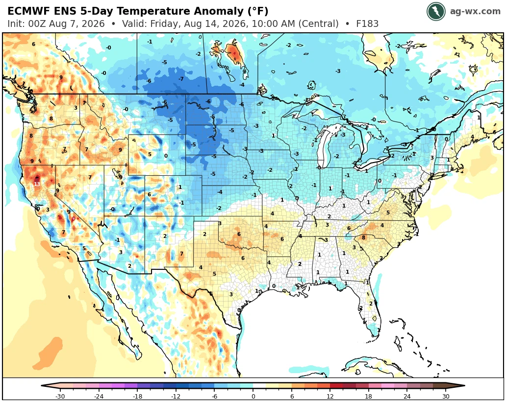
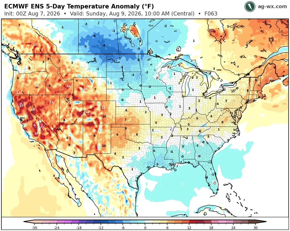
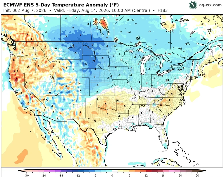
Looks like the heat and humidity will begin to ease up next week.
-
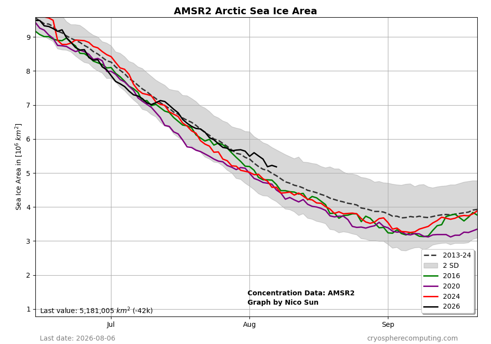
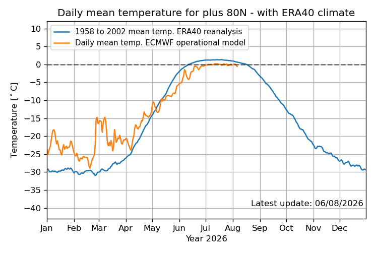
Arctic ice area has been doing relatively well vs the 2013-24 average! This has quite possibly been helped by the coldest late May-early Aug on record per DMI 80+ N Arctic mean temp since records started in 1958:
-
Are we this damn lazy as a people?
-

2026-2027 Record-breaking El Nino
GaWx replied to Stormchaserchuck1's topic in Weather Forecasting and Discussion
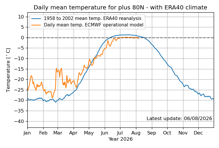
Arctic ice area has been doing relatively well! This has quite possibly been helped by the coldest late May-early Aug on record per DMI 80+ N Arctic mean temp since records started in 1958: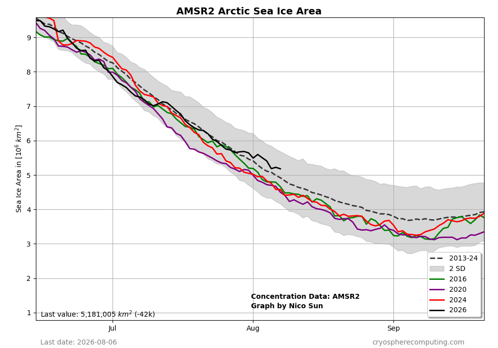
-
Records: Highs: EWR: 100 (2001) middle of the record heatwave NYC: 104 (1918) LGA: 99 (2001) JFK: 96 (2001) Lows; EWR: 57 (1948) NYC: 57 (1994) LGA: 61 (1975) JFK: 59 (2004) Historical: 1904 - A flash flood near Pueblo, CO, washed a train from the tracks killing 89 passengers. A bridge, weakened by the floodwaters sweeping through the valley below, gave way under the weight of the train dashing all but the sleeping cars into the torrent drowning the occupants. Rail service was frequently interrupted in the Rocky Mountain Region and southwestern U.S. that summer due to numerous heavy downpours which washed out the railroad beds delaying trains as much as five days. (David Ludlum) (The Weather Channel) 1918 - Philadelphia, PA, established an all-time record with a high of 106 degrees. New York City experienced its warmest day and night with a low of 82 degrees and a high of 102 degrees. Afternoon highs of 108 degrees at Flemington NJ and Somerville NJ established state records for the month of August. (The Weather Channel) (Sandra and TI Richard Sanders - 1987) 1924: A tornado caused estimated F4 damage moved southeast from south of Osseo, WI to Black River Falls, WI. One person was killed as a home was leveled and a boy was killed running to the storm cellar near the start of the path. Two people died as farm homes were swept away near the northeast edge of Black River Falls. Damage totaled $200,000 as 50 farms were hit and buildings were unroofed in the town of Northfield. The tornado followed the present route of Interstate 94. 1968: During the late afternoon and evening hours numerous severe thunderstorms developed across eastern South Dakota, but the most powerful storm moved through the Huron area. Wind gusts of an incredible 115 mph swept through the area. The force of the winds blew over a radio tower and also did major damage to area roofs and houses. Not only were the winds very strong, but hail up to the size of softballs pounded the area and four funnel clouds were sighted. (Ref. Wilson Wx. History) 1979: Three different hailstorms struck Spearfish, SD in the same afternoon. One produced baseball size hail and the other two produced hailstones to golf ball size. (Ref. AccWeather Weather History) 1980: Hurricane Allen bottomed out at 899 millibars (26.55 inches of mercury) while moving through the Yucatan Channel in the southeastern part of the Gulf of Mexico. Allen was the second lowest pressure ever recorded in the Western Hemisphere up to that time. Allen's winds at the time were sustained at 190 mph. 1983: Sheridan, WY hit 106°, their all-time record high for August. Thunder Bay, Ontario Canada reached an all-time record high of 104.5°. (Ref. AccWeather Weather History) 1984 - El Paso, TX, normally receives 1.21 inches of rain in August. They got it in forty-five minutes, with four more inches to boot, during a storm which left Downtown El Paso under five feet of water. (The Weather Channel) 1986 - A rare outbreak of seven tornadoes occurred in New England. One tornado carved its way through Cranston RI and Providence RI causing twenty injuries. Rhode Island had not reported a tornado in twelve years, and three touched down in 24 hours. (Storm Data) (The National Weather Summary) 1987 - Morning thunderstorms drenched Goldsboro, NC, with 3.37 inches of rain. Late morning thunderstorms in Arizona produced dime size hail, wind gusts to 50 mph, and two inches of rain, at Sierra Vista. (The National Weather Summary) (Storm Data) 1988 - A dozen cities in the central U.S. reported record high temperatures for the date, including Waco, TX, with a reading of 107 degrees. The record high of 88 degrees at Marquette, MI, was their twenty-third of the year. Afternoon and evening thunderstorms produced severe weather in Nebraska, Minnesota and Wisconsin, with wind gusts to 81 mph reported at McCool, NE. (The National Weather Summary) (Storm Data) 1989 - Forty cities in the central U.S. reported record low temperatures for the date, including Valentine, NE, with a reading of 40 degrees, and Belcourt ND with a low of 37 degrees. Martin SD was the cold spot in the nation with a morning low of 30 degrees. Unseasonably hot weather prevailed over Florida and Washington State, with record highs of 100 degress at Daytona Beach, FL, 101 degrees at Walla Walla, WA, and 103 degrees at Hanford, WA. (The National Weather Summary) 1990: Nome, Alaska: Nome records its ninth thunderstorm of the year, more than the city had observed in the previous twenty years combined. (Ref. WxDoctor) 1993: The Great Mississippi River Flood of 1993 continued. The main flood crest reached Cairo, IL where the river is joined by the Ohio River. No serious flooding will occur further south because the river becomes wider and deeper. (Ref. AccWeather Weather History) 1994: Two complexes of thunderstorms developed over southern Minnesota and north central Nebraska. The two complexes then slowly merged with each other in time. Large hail and high winds were common in southeast South Dakota and northwest Iowa with hail ranging in size from dimes to golf balls. In Cherokee County, hail damage was reported to many cars in the city of Cherokee by hail two inches in diameter. About 150 cars and 100 homes were damaged by the hail. A tornado also touched down northwest of Sibley in Osceola County, damaging several buildings at a farmstead. At the same time, a car was lifted and thrown 50 feet. Woodbury and Monona Counties were hard hit with high winds, with many winds reported at 60 to 65 mph. The Mapleton area in Monona County was particularly hard hit where a roof was blown off of a car dealership and another roof caved in at an apartment building. Severe thunderstorms struck much of the southern two-thirds of Oklahoma and parts of western north Texas. The costliest damage was at Prague, in Lincoln County, where 90 mph winds were reported, resulting in more than $1 million in damages. Another storm struck Thackerville, in Love County, where lightning struck a power pole, traveled through a line to a school, and started a fire that destroyed the school. Hail the size of dimes and quarters was very common across Oklahoma that day, and hail up to golf ball-size fell in Clay and Archer Counties of north Texas. (Ref. Wilson Wx. History) 2000: A 33-year-old man was struck and killed under a tree at the West Falls Church, VA Metro Station as a severe thunderstorm swept through the area. (Ref. Lightning - Virginia Weather History) 2007: A rare and destructive F2 tornado with winds of up to 135 miles an hour whipped southwestern Brooklyn in New York. The funnel cloud was hidden in heavy rain and thus no pictures were obtained. (Ref. F2 Tornado Hits Brooklyn) 2020: The heavy rains started on the 4th from Tropical storm Isaias that brough 2.53 inches of precipitation to Springfield Park on the 4th and some areas had a lot more rain. This was followed by 4 more days of heavy rainfall in the Richmond area.(Ref. The Richmond Times Dispatch)
-
83 / DP : 75. Southern Florida pattern / tropical style continues through Tuesday, overall hot/humid with storm and downpours. Places will see 90s during the 6 day stretch and potentially all for a 6 day heatwave Thu around the Atlantics ridge and S/SW flow. Beyond there 8/12 the Atalntic ridge pushes south and western ridge builds back pushing a trough into the northeast - near / slightly below normal 8/12 - 8/16 before moderation back to near normal overall.
-

Central PA Summer 2026 Discussion/Obs Thread
Mount Joy Snowman replied to Voyager's topic in Upstate New York/Pennsylvania
I’m right in the middle of the two of ya, with .51”, which makes perfect sense ha. Low of 70. Man, Training you’ve really been getting screwed lately. We’ll see what today brings. -
2026-2027 Record-breaking El Nino
GaWx replied to Stormchaserchuck1's topic in Weather Forecasting and Discussion
Although the -SOI streak is up to a whopping 89 days and it will reach the low 90s (2nd longest on record back to 1991 by a large margin to early 1998’s 100 days), there’s a good chance it will finally end early next week short of the 100 day record with at least one smallish +SOI as it now appears. Let’s see what actually happens. -

Augdewst 2026: Summer's Last Stand
40/70 Benchmark replied to Prismshine Productions's topic in New England
I had a brief shower around 11pm...just .02". -
-

Augdewst 2026: Summer's Last Stand
Damage In Tolland replied to Prismshine Productions's topic in New England
Well Wiz promised the circled red area would get crushed so there’s hope ! -
2026-2027 Record-breaking El Nino
40/70 Benchmark replied to Stormchaserchuck1's topic in Weather Forecasting and Discussion
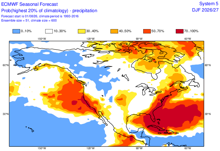
Looks like -WPO is favored next winter? Would fit with the theme of the recent shift. -
2026-2027 Record-breaking El Nino
40/70 Benchmark replied to Stormchaserchuck1's topic in Weather Forecasting and Discussion
The map looks like something @MJO812drew up on the shitter, but I largely endorse the narrative. -
Hrrr jumping back onboard
- 1,725 replies
-
- 2
-

-

-
- severe
- thunderstorms
- (and 7 more)
-

Augdewst 2026: Summer's Last Stand
CoastalWx replied to Prismshine Productions's topic in New England
I could care less now. Convection is dumb. -
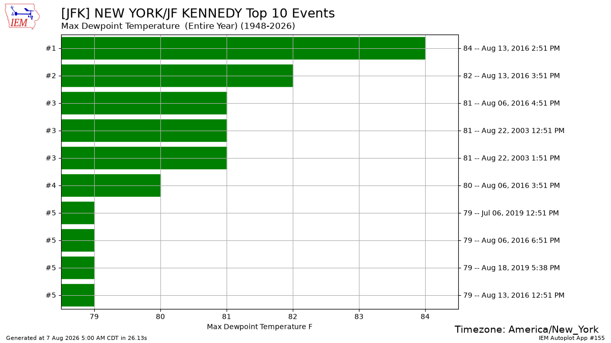
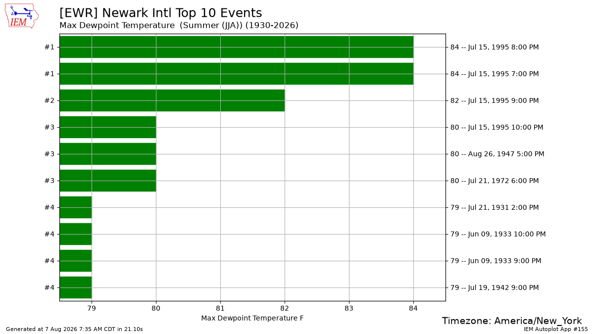
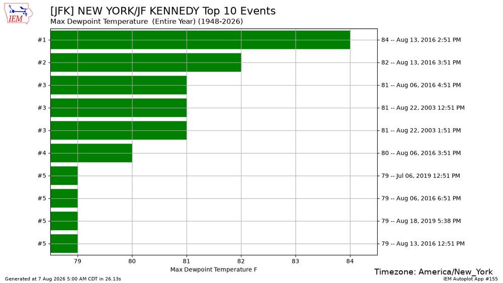
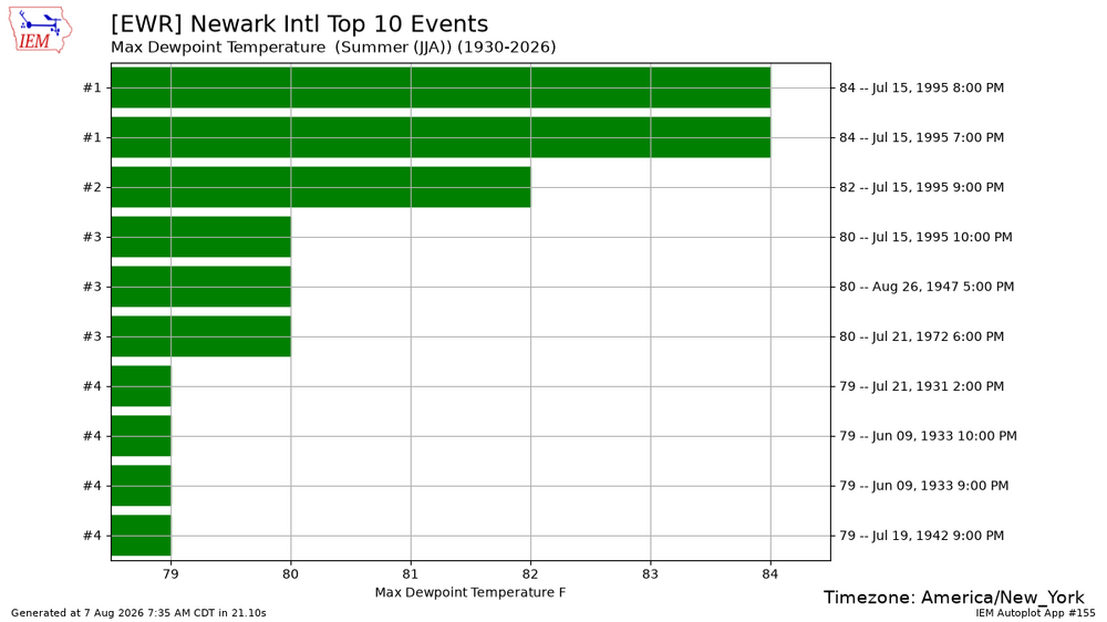
The list is different for each station due to local dew point variations. The record for Newark was set in 1995. While the JFK record was back in 2016.
-
Augdewst 2026: Summer's Last Stand
Damage In Tolland replied to Prismshine Productions's topic in New England
Yes this whole streak and Yanks collapse has greatly contributed to that I fully admit -

Augdewst 2026: Summer's Last Stand
dendrite replied to Prismshine Productions's topic in New England
Min 70.0° Rare 70+ for here -
-

Augdewst 2026: Summer's Last Stand
SouthCoastMA replied to Prismshine Productions's topic in New England
76/74 - rough without central air. -
 Viagra without a doctor prescription Canada and Cheap generic Viagra Cheapest Sildenafil online https://www.coloradoballet.org/redirect.aspx?destination=http://sildoliko.shop sildenafil 50 mg price or http://www.freeworld.imotor.com/space.php?uid=211363 cheapest viagra [url=https://images.google.co.uz/url?q=https://sildoliko.shop]viagra canada[/url] buy Viagra over the counter or [url=https://act2day.eu/profile/wddalgokpa/]viagra without prescription[/url] Viagra tablet online
 -
Augdewst 2026: Summer's Last Stand
dendrite replied to Prismshine Productions's topic in New England
3rd place tonight? -
Augdewst 2026: Summer's Last Stand
Damage In Tolland replied to Prismshine Productions's topic in New England
The final nail will be when SNH, Ineedsnow and Ray get another unmodeled squalline that develops at 11 PM and rips thru that area