All Activity
- Past hour
-

2025-2026 ENSO
40/70 Benchmark replied to 40/70 Benchmark's topic in Weather Forecasting and Discussion
That looks pretty realistic. -
Yeah that's what I meant- the extended products continue the same advertised longwave pattern from the end of the ens runs the beginning of the month. And I agree- given we will be in Nov with that look, frost/freeze should be a thing outside of the UHI.
-

E PA/NJ/DE Autumn 2025 Obs/Discussion
MGorse replied to PhiEaglesfan712's topic in Philadelphia Region
0.27” of rain last night. Definitely more than what I was expecting. -
Here's the 12z EPS for reference. Right now, follow the ensembles. The clustering/highest probabilities keep it well off the coast. This is a complex setup and there will be lots of moving parts. The chance of a New England impact is still very low, but I do believe worth keeping an eye on. We've already seen this tropical season major shifts in guidance in the 7-10 day range vs what actually happened.
-

Mid to long range discussion- 2025
WinstonSalemArlington replied to wncsnow's topic in Southeastern States
-

Spooky Season (October Disco Thread)
CoastalWx replied to Prismshine Productions's topic in New England
I think we all know it's low chance. But it's fun to fire up Kev only to see his disappointment a week later. -
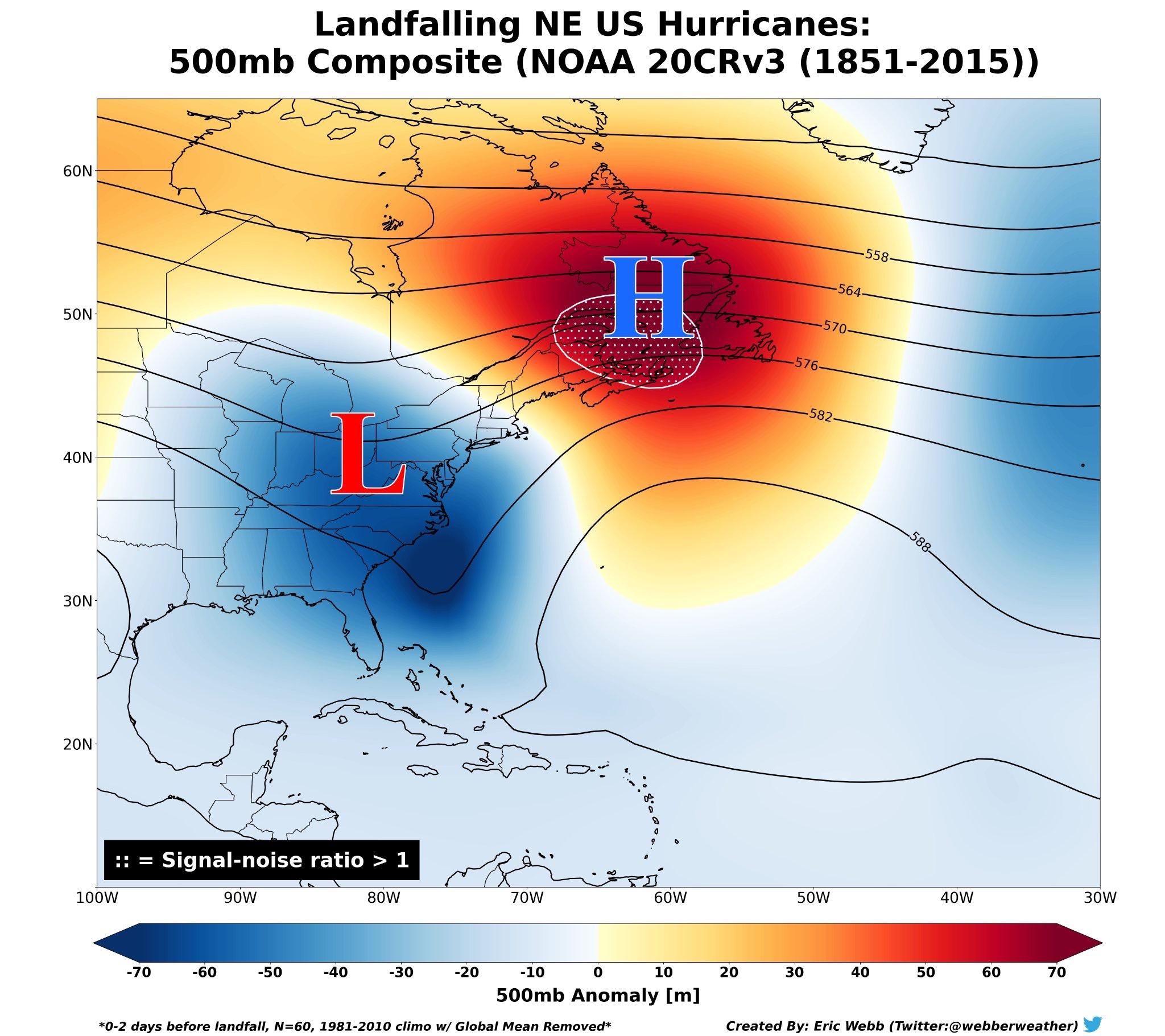
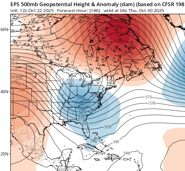
Just a reminder of what the typical upper level setup looks like for New England landfalling hurricanes. Obviously this is a broad brushed composite, but there are a lot of similarities to the currently forecast upper-level pattern from the EPS. New England hurricanes are rare for a reason - even if the overall larger pattern supports the possibility, the smaller details, exact placement of trough/ridges, etc. will have a role in impact (i.e. trough interaction) vs no impact (less trough interaction)

-
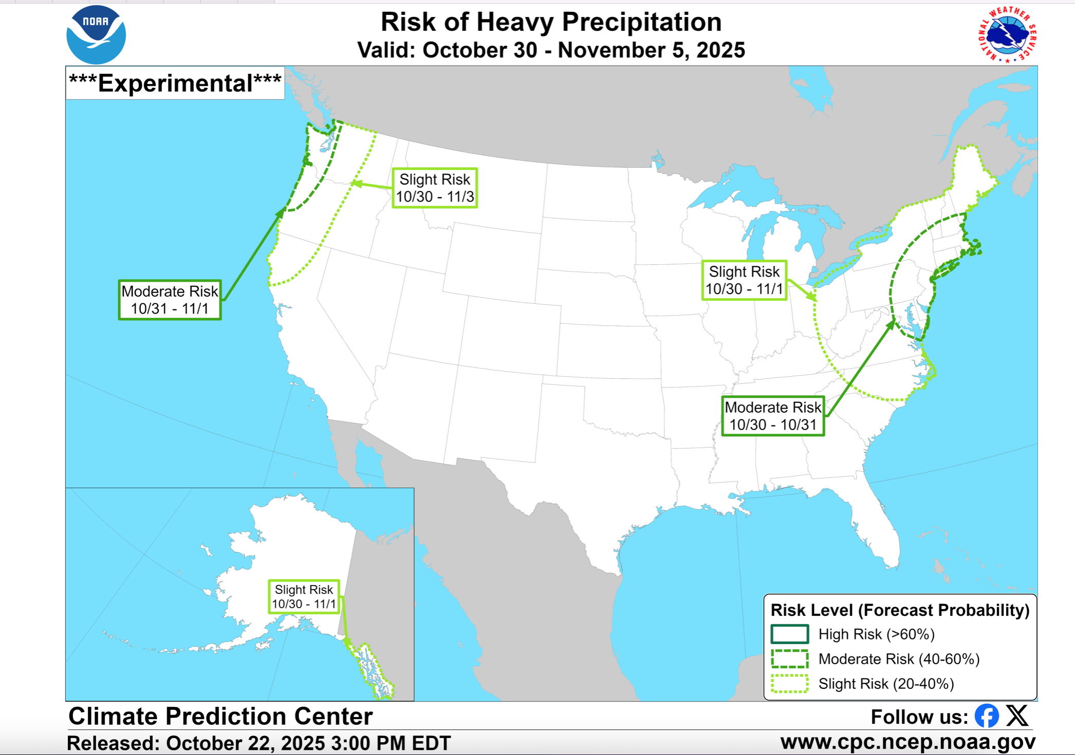
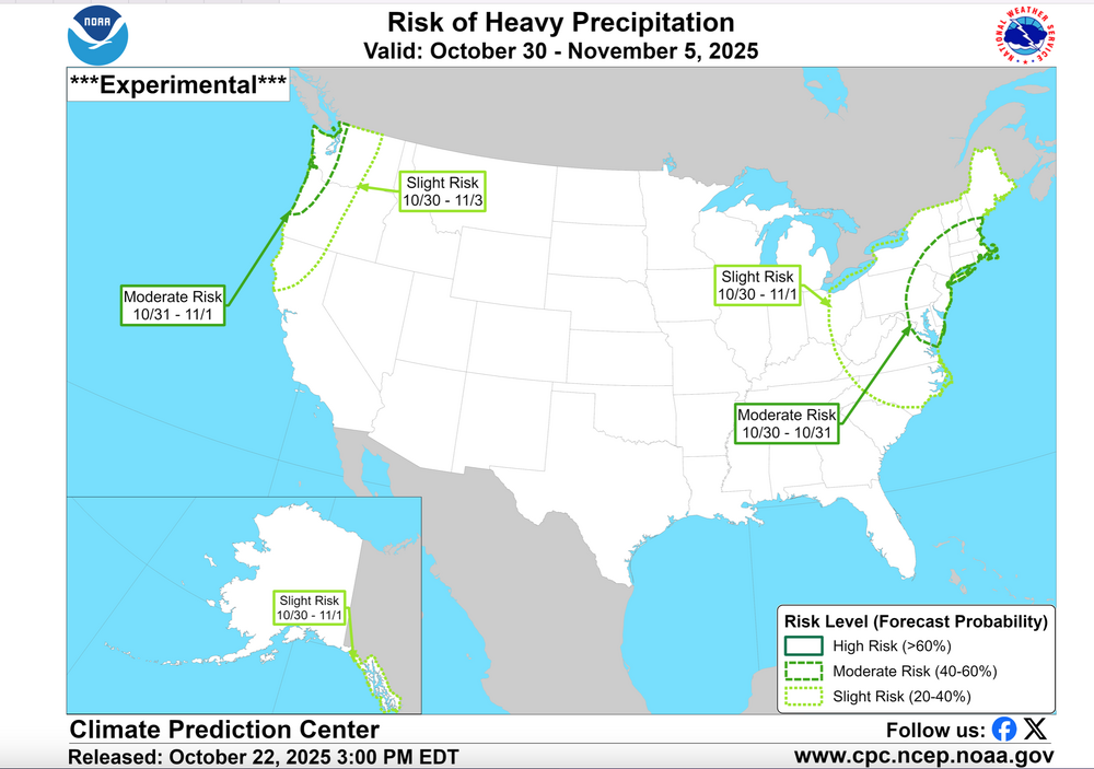
YES... CPC this afternoon continues MDT RISK heavy rain our area. IF I had to make a decision at 5PM today, I would not thread. Too much uncertainty on anything more than 1/4". Upper 5H low needs to form and capture the sfc low. northward along the coast......sometimes this occurs too late. D7 WPC qpf this afternoon is a good start. The CPC 3PM/22 discussion below supports the attached graphic... MDT Risk in my opinion also implies a risk of a miss to the east. The discussion below to the attached graphic. As the troughing moves further east, frontal activity and possible surface low pressure are predicted to bring increased precipitation chances to the East. The forecast is further complicated by the evolution of Tropical Storm Melissa, currently over the Caribbean. Individual ensemble members from the GEFS and ECENS vary greatly with Melissa, with a more west-based track currently more favored in the ECENS. Slower solutions are concerning given the possibility for more frontal interaction with the upstream trough. Today's ECENS and deterministic ECMWF solutions have trended more to the east compared to yesterday showing enhanced precipitation across the northern Mid-Atlantic into New England. While the uncalibrated ECENS indicates at least a 40 percent chance of day 8-10 (Oct 30-Nov 1) precipitation totals exceeding 1-inch over these areas, the GEFS generally keeps chances closer to 20 percent. While uncertainty remains high in regards to the exact evolution, especially in regards to any tropical cyclone interaction, a moderate risk for heavy precipitation remains highlighted across portions of the northern Mid-Atlantic and Northeast, Oct 30-31 considering the timing includes Halloween and potential for adverse impacts to outdoor events. A slight risk of heavy precipitation continues through Nov 1, with the slight risk of high winds extending across the Great Lakes, Northeast, and Mid-Atlantic through Nov 1.
-
Cayman Islands may also have a serious problem with this storm, especially if it gets as intense as a pretty significant chunk of guidance suggests it could.
-

Spooky Season (October Disco Thread)
Torch Tiger replied to Prismshine Productions's topic in New England
Yeah it's very low chances, but certainly not impossible. Even the ensemble "clusters" or "camps" are a mess through D5, even D2. lol so we'll see where things land in a few days. -
Spooky Season (October Disco Thread)
CoastalWx replied to Prismshine Productions's topic in New England
"This is our time, it's our time down here...." -
Mid to long range discussion- 2025
WinstonSalemArlington replied to wncsnow's topic in Southeastern States
Spooky! -
Or maybe the AI doesn’t explicitly model ptypes? And it’s just weatherbell saying precip+850-0C line = snow?
-

October Medium/Long Range Discussion
NorthArlington101 replied to Eskimo Joe's topic in Mid Atlantic
Mental note not to take this product too seriously… feel like for this kind of result it’s gotta be weird ptype issues. -
First week too based on 12z ensembles. You’d think we’d be able to get widespread freezes with that look…
-
While it is always fun to fantasize about extreme events, this setup is still a long shot for New England! Signal for a violent Atlantic system is strong, but right now I think the chance it has direct impacts for most of the Northeast is low. It is not like the ensembles show a clustering into New England. The Canadian has always been good for weather porn, but rarely leads the way. After a while, chasing the one or two outlying ensemble members gets old. I would love to see a late October monster hybrid, but until I see a wholesale change in where the main ensemble cluster sets up, I would recommend keeping expectations very much on the low side. Although if I were living in NS I'd keep close tabs.
-
Bastardi saw it
-
This would have been a fantastic LES event in a few months. Regardless I am glad to finally be getting some rain. We could definitely use it.
-
In Calvert I'm at about 100ft and the cabin is just over 3k ft.
-
Going to be a cold one the next several nights. Today's high was 62 after a low of 31. Oh and um the pattern has changed.
-

Central PA Fall Discussions and Obs
Mount Joy Snowman replied to ChescoWx's topic in Upstate New York/Pennsylvania
Yeah people complain about the weather no matter where they live but ours really is so benign compared to most regions. I’ve always thought we live in a top-notch weather location. I love it here. -

Spooky Season (October Disco Thread)
Damage In Tolland replied to Prismshine Productions's topic in New England
It’s our turn.. it’s our time -

E PA/NJ/DE Autumn 2025 Obs/Discussion
JTA66 replied to PhiEaglesfan712's topic in Philadelphia Region
La-la-lock it up!! -

Spooky Season (October Disco Thread)
Lava Rock replied to Prismshine Productions's topic in New England
what a dump fest in pwm -
Anyone up for a chase to Bermuda? Couple of frames show it… 10, 13, 15….