All Activity
- Past hour
-

May 2024 Discussion - Welcome to Severe Season!!!!
dendrite replied to weatherwiz's topic in New England
No choice once he realizes he installed it backwards. -

Occasional Thoughts on Climate Change
Stormchaserchuck1 replied to donsutherland1's topic in Climate Change
Actually, just speaking from personal observation, it's the Sun. Does higher CO2 deplete the ozone to make the sun shine brighter to ground heat? -

May 2024 Discussion - Welcome to Severe Season!!!!
Lava Rock replied to weatherwiz's topic in New England
67/44. Beautiful night Sent from my SM-S921U using Tapatalk -

Central Pa. Spring 2024
TheClimateChanger replied to mahantango#1's topic in Upstate New York/Pennsylvania
What? I don’t know what TL or DR means, but those monthly anomalies would result in one of the hottest summers on record surely. -
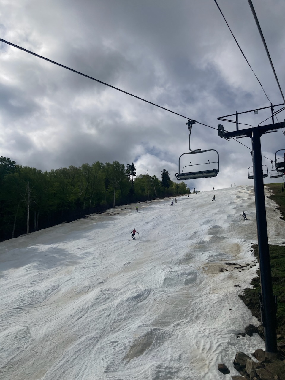
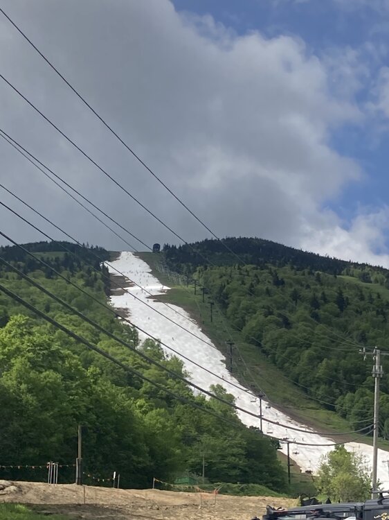
Killington was pretty fun this past Sunday. Walking required, but not bad. Chance of rain seemed to keep the crowds down. Skiing was fine with a few decent icy trough bump lines to be had. Met some pretty hardcore riders on the lift, one guy had skied 194 days this past season. Day 100 for me, I’m probably done. Good to end on a nice round number.

-
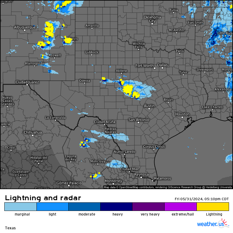
Texas 2024 Discussion/Observations
Stx_Thunder replied to Stx_Thunder's topic in Central/Western States
Watching evolution & southward progression of the new MCCs ongoing in the hill country (northwest of Austin), and in NM going into tonight, as of typing this. Looks to definitely effect San Antonio area this evening. - - - Got a strong outflow front from the MCS moving through Houston area and out over the Gulf earlier this morning with some 50 mph gusts and heard some nice CGs, along with some more modest rainfall. Things are probably too stable now over NTX - SETX for much of anything else through tonight from this morning’s sharply organized system. But would think it’ll pick up again in those regions by later tomorrow/night. Especially with some better ML shortwave energy projected to track through the state at times this weekend on both Euro & GFS.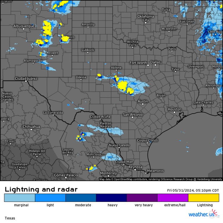
-
With apologies to May 30th, Mike Vecchione is turning into Mr. June.
-
 DCA: +1.2 101NYC: +1.3 98BOS: +1.3 98ORD: +0.9 99ATL: +1.3 102IAH: +1.8 106DEN: +1.7 98PHX: +1.7 119SEA: +0.6 97
 -
76 today. Beautiful
-
WGAL throws down the gauntlet and says you may need an umbrella for Sunday golf in Lanco.
- Today
-
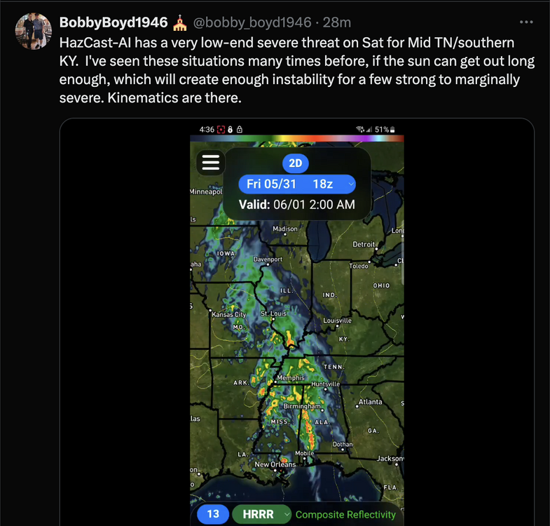
Right now, SPC has a Marginal Risk for west/middle TN. As BB tweeted earlier, if we can get some instability tomorrow, the kinematics are there. One must wonder if this is a sleeper threat that should be upgraded to a Slight Risk sooner rather than later?
-
A Historically great end to May weather wise
-
May 2024 averaged 69.3 degrees at DCA, tied for 16th warmest in DC history (2015 is warmest at 73.2 and 1882 is coolest at 59.2). January-May 2024 at DCA averaged 53.2, 4th warmest in DC history, behind 2012 (54.4), 2023 (53.7), and 2017 (53.3).
-
This is how you draw up a Saturday to start June. BTV is certainly enthused. We can look forward to a warming trend as we begin meteorological summer. Saturday looks to be gorgeous days for outdoor activities, with highs 74-82, plentiful sunshine and comfortable humidity. Area waters are still on the cool side with water temperatures in the low to mid 60s. Given that it is the weekend and with sunny condition and temperatures reaching the low 80s, cold water safety should be exercised for those taking advantage of the gorgeous weather. While upper ridging builds in from the west, we do maintain a light northerly flow below 850mb level so the air mass will be continental polar in nature. Dew points will be in the 40s so the weather will be gorgeous to be outdoors.
-

May 2024 Discussion - Welcome to Severe Season!!!!
powderfreak replied to weatherwiz's topic in New England
Don't even look at it wrong. -

May 2024 Discussion - Welcome to Severe Season!!!!
DavisStraight replied to weatherwiz's topic in New England
Don't touch it, unless you hear the noise again. -
78 / 42 out there just gorgeous.
- 1,600 replies
-
- 1
-

-
- spring
- cool temps
- (and 3 more)
-
Records: Highs: EWR: 98 (2022) NYC:96 (1939) LGA: 96 (1987) JFK: 94 (2022) Lows: EWR: 44 (1938) NYC: 46 (1938) LGA: 50 (2021) JFK: 48 (2023) Historical: 1830: Shelbyville, Tennessee was turned into "a heap of ruins" as a tornado moved east through the center of the town. This tornado destroyed 15 homes and 38 businesses along with churches and other public buildings. Losses were estimated to be as high as $100,000. A book was said to be carried seven miles away. 1889 - The Johnstown disaster occurred, the worst flood tragedy in U.S. history. Heavy rains collapsed the South Fork Dam sending a thirty foot wall of water rushing down the already flooded Conemaugh Valley. The wall of water, traveling as fast as twenty-two feet per second, swept away all structures, objects and people. 2100 persons perished in the flood. (David Ludlum) 1941 - Thunderstorms deluged Burlington KS with 12.59 inches of rain to establish a 24 hour rainfall record for the state. (The Weather Channel) 1985 - Severe thuunderstorms spawned forty-one tornadoes across the Lower Great Lakes Region and southeastern Ontario which killed 74 persons. (Storm Data) 1987 - Thunderstorms in New England produced wind gusts up to 90 mph at Worcester, MA, and Northboro, MA, and hail an inch and a half in diameter at Williston, VT. Unseasonably hot weather prevailed in the northeastern U.S. The afternoon high of 94 degrees at Portland, ME, was a record for the month of May. (Storm Data) (The National Weather Summary) 1988 - Hot and humid weather prevailed in the eastern U.S. Thirteen cities reported record high temperatures for the date. Cape Hatteras, NC, reported their first ninety degree day in May in 115 years of records. "Dust buster" thunderstorms in northwest Texas drenched Amarillo with more than three inches of rain. (The National Weather Summary) 1989 - Thunderstorms produced severe weather and torrential rains in northern Indiana, northern Ohio and southern Lower Michigan. Saint John IND was drenched with four inches of rain in two hours, and Woodland MI was deluged with two inches in twenty minutes. Pittsburgh PA reported a record 6.55 inches of rain for the month of May, with measurable rain reported on twenty-five days during the month. (The National Weather Summary) 1990 - Afternoon and evening thunderstorms developing along a warm front produced severe weather from northwest Texas to southeastern Louisiana. The thunderstorms spawned sixteen tornadoes, including thirteen in northwest Texas. One tornado hit the town of Spearman, TX, causing more than a million dollars damage, and seven other tornadoes were reported within twenty-five miles of Spearman. Thunderstorms over northwest Texas also produced baseball size hail at Monahans, and wind gusts to 80 mph at Paducah. (The National Weather Summary) (Storm Data) 2013: The 2nd of the top 10 weather events for 2013 was EL Reno, Oklahoma tornado of May 31, 2013. Part of the multi-day storm outbreak caused $2 billion in damage. The EF3 that traveled through the western suburbs of Oklahoma City was the largest tornado ever observed with a width of 2.6 miles. It took eight lives including four tornado chasers.
-

May 2024 Discussion - Welcome to Severe Season!!!!
weatherwiz replied to weatherwiz's topic in New England
Well this is odd. I’m about to take the AC out of the window so I can open the casing and see what’s going on. But my girlfriend says let’s turn it in and try again. With it light out we may be able to see inside a bit better. We turn it on…and it runs smoothly with no noise lol -
https://www.x.com/commoditywx/status/1796588170747969744
-
 23/13/6
 -
Scattered showers most of the day here. Temps bouncing between 64-66 all day. Looks like more organized rain is moving in to cap off a very wet month.
-
May finished with a mean temperature of 65.1° (1.9° above normal) in New York City. A warm and generally dry weekend with highs in the upper 70s and lower 80s lies ahead. Afterward, the first half of next week will be dry with temperatures topping out in the upper 70s and lower 80s. Warm spots could reach the middle 80s. Rain could arrive late Wednesday or Thursday. The latest summer guidance continues to suggest a warmer to much warmer than normal summer lies ahead. The ENSO Region 1+2 anomaly was -1.1°C and the Region 3.4 anomaly was +0.2°C for the week centered around May 22. For the past six weeks, the ENSO Region 1+2 anomaly has averaged -0.40°C and the ENSO Region 3.4 anomaly has averaged +0.45°C. Neutral conditions are imminent. The SOI was +9.29 today. The preliminary Arctic Oscillation (AO) was -0.350 today. On May 28 the MJO was in Phase 3 at an amplitude of 1.457 (RMM). The May 27-adjusted amplitude was 1.609 (RMM).
- 1,600 replies
-
- 1
-
-
- spring
- cool temps
- (and 3 more)
-
Im wearing shorts!! But the heat was on this morning!
-
May 2024 Discussion - Welcome to Severe Season!!!!
powderfreak replied to weatherwiz's topic in New England
72F with dews in the 30s… got that Chamber feelin’.