All Activity
- Past hour
-
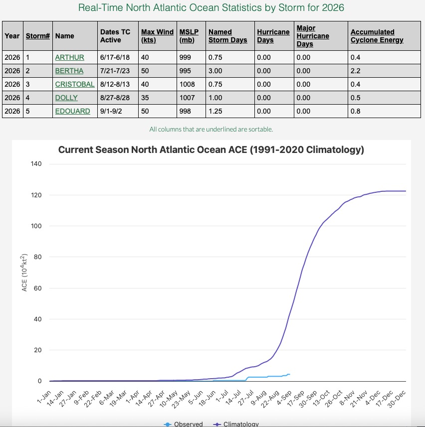
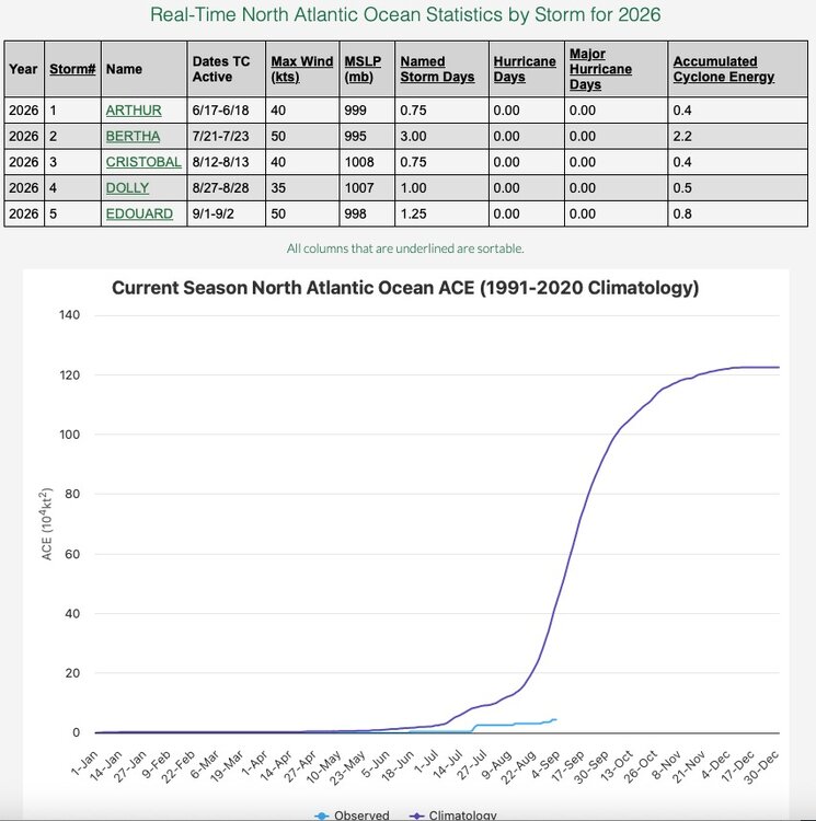
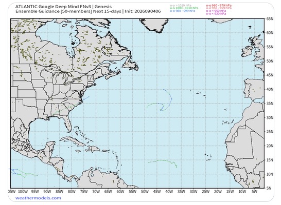
Just in case you were wondering what the status of the 2026 hurricane season is: That is one quiet looking signal from Google Deep Mind going into mid month.
-
September 4 1992: Early morning storms result in 3/4 to 1 3/4 inch hail in Hennepin, Dakota, Rice and Goodhue Counties. 1941: A batch of tornadoes hits Minneapolis, New Brighton, and White Bear Lake, killing six people. 1925: The third consecutive day of 95 degrees or above occurs in the Minneapolis area. For Friday, September 4, 2026 1939 - A thunderstorm deluged Washington D.C. with 4.4 inches of rain in two hours. September of that year was very dry across much of the nation, and Washington D.C. received more rain in that two hour period than most other places in the country that entire month. (David Ludlum) 1970 - The greatest natural disaster of record for Arizona occurred. Unprecedented rains caused rivers in central Arizona to rise five to ten feet per hour, sweeping cars and buildings as far as 30 to 40 miles downstream. Flooding claimed the lives of 23 persons, mainly campers, and caused millions of dollars damage. Water crested 36 feet above normal near Sunflower AZ. Workman's Creek was deluged with 11.40 inches of rain in 24 hours to establish a state record. Moisture from Pacific Tropical Storm Norma led to the severe flooding. (4th-6th) (The Weather Channel) 1986 - An unusually strong dust devil moved across the Flagstaff Pulliam Airport. The dust devil blew open the doors of the National Weather Service office scattering papers and bringing down a ceiling-mounted light fixture. (Storm Data) 1987 - Thunderstorms developing along a stationary front produced heavy rain across the Southern Atlantic Coast States. Up to eight inches was reported north of Charleston SC. Serious flooding was reported in Monks Corner SC. Seven cities in the northeastern U.S. reported record low temperatures for the date. Houlton ME dipped to 32 degrees. (The National Weather Summary) (Storm Data) 1988 - The western U.S. experienced another day of record heat. The afternoon high of 91 degrees at Stampede Pass WA established an all-time record for that location, and Los Angeles CA equalled their all-time record high with a reading of 110 degrees. A record high of 107 degrees at San Diego CA was their hottest reading in 25 years. Red Bluff CA was the hot spot in the nation with an afternoon reading of 118 degrees. (National Weather Summary) 1989 - Overnight thunderstorm rains of four and a half to seven inches drenched eastern Nebraska during the morning hours, pushing creeks out of their banks, and flooding fields, country roads and city streets. Totals ranged up to 6.97 inches south of Creston. It was also a soggy Labor Day for northern Florida. Jacksonville reported 6.82 inches of rain, and evening thunderstorms produced 2.75 inches of rain in one hour at Sandlewood. (Storm Data) (The National Weather Summary) Observances: 4 Fri National Lazy Mom’s Day 4 Fri National Food Bank Day 4 Fri World Sexual Health Day 4 Fri National Wildlife Day 4 Fri Eat an Extra Dessert Day 4 Fri Bring Your Manners To Work Day 4 Fri Janmashtami 4 Fri National Macadamia Nut Day
-

Fall 2026 Med/Long range discussion
SchaumburgStormer replied to Brian D's topic in Lakes/Ohio Valley
Winter cancel -
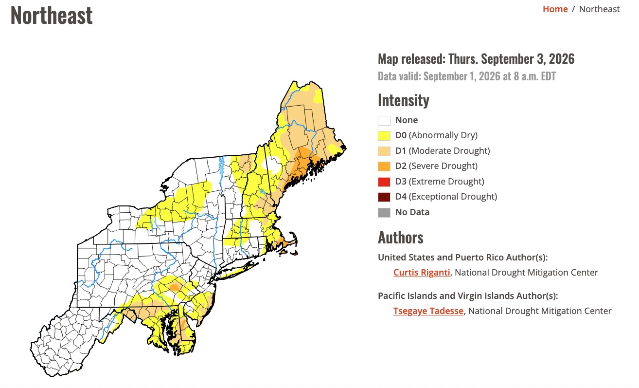
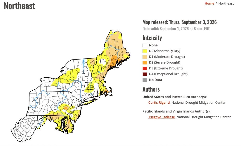
Just in case you were wondering about what the latest Drought Monitor looked like: I think we're all GOOD !
-
Essentially never lose power here
-
The updated monthly Euro seasonal forecast as of Sept 1st is due to be released tomorrow.
-
0.86" of rain with a general 1" around the area from storms last night. Very welcome. It was a windy day yesterday with ENE winds and temps around 70. Same on tap today without the rain.
-
No power since 1am and no restoration time. Can't believe it, but I miss ComEd lol WE Energies is a joke
-
(002).thumb.png.6e3d9d46bca5fe41aab7a74871dd8af8.png)
Central PA Summer 2026 Discussion/Obs Thread
ChescoWx replied to Voyager's topic in Upstate New York/Pennsylvania
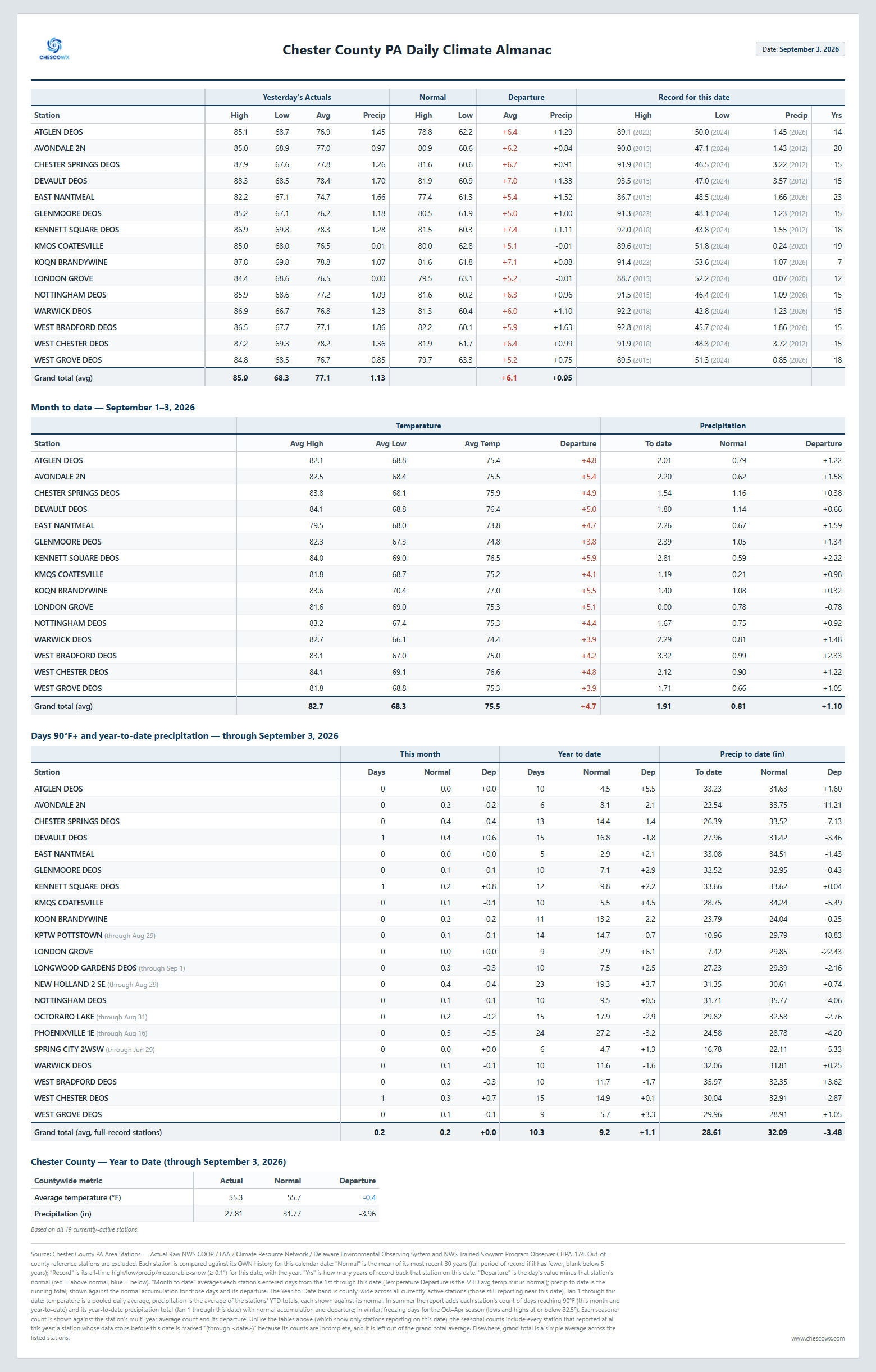
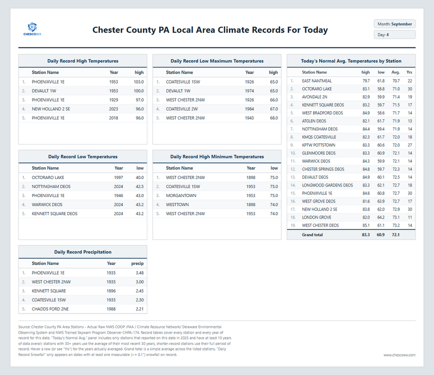
We start to see humidity levels drop today and we will see our temperatures return to near normal today and then below normal through the upcoming Labor Day Weekend. Highs through the weekend will be in the mid to upper 70's and lows in the 50's for most spots with some 40's possible in our coldest valley locations by Monday morning. Slight rain chances tonight and again by next Wednesday night.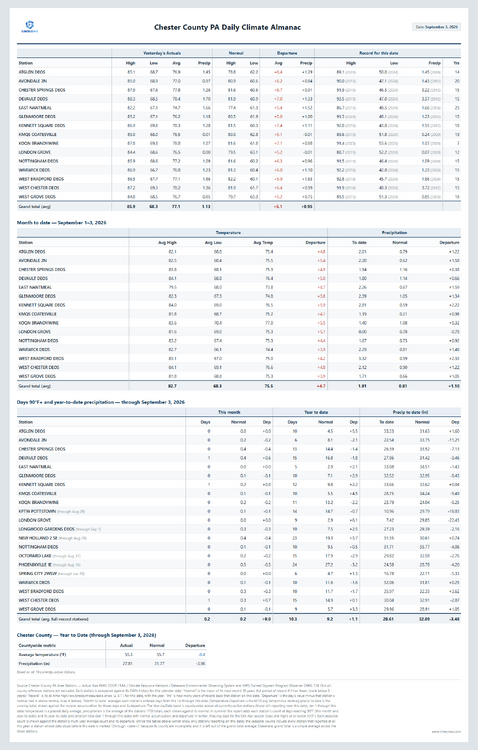
-
E PA/NJ/DE Summer 2026 Obs/Discussion
ChescoWx replied to PhiEaglesfan712's topic in Philadelphia Region
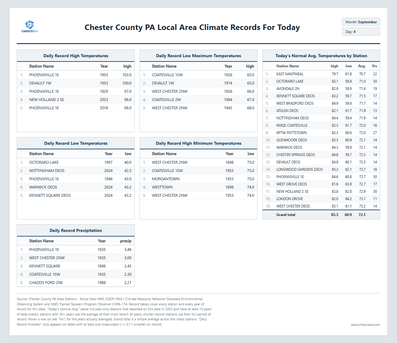
We start to see humidity levels drop today and we will see our temperatures return to near normal today and then below normal through the upcoming Labor Day Weekend. Highs through the weekend will be in the mid to upper 70's and lows in the 50's for most spots with some 40's possible in our coldest valley locations by Monday morning. Slight rain chances tonight and again by next Wednesday night.
-
Social media has fostered an enormous proclivity for the development of these highly superficial and useless maps in the place of in-depth analysis.
-
Picked up .60" here overnight. Total for the month already at 1.55". Looks like a drier pattern for the next 5-7 days. Thankfully.
-

E PA/NJ/DE Autumn 2026 Obs/Discussion
Newman replied to PhiEaglesfan712's topic in Philadelphia Region
The big wildcard this winter will certainly be if we can get a few well-timed antecedent cold snaps to align with a big southern stream system! -

Septorcher 2026 Discussion - Endless Summer
40/70 Benchmark replied to Damage In Tolland's topic in New England
Here is a crazy idea...how about objectivity over negativity and positivity? Just a thought- -
Nothing here last two days but heat and humidity. Two back-to-back 92.0 degree highs, last one ALMOST set a record for date (93 degrees in 2011).
-

2026 Mid-Atlantic Severe Storm General Discussion
Herb@MAWS replied to Kmlwx's topic in Mid Atlantic
The next batch of rain coming SE-ward from Southern Michigan and northern Ohio appears to have a slightly better angle of approach toward Central Maryland than the past 2 days. Of course the day is young and I could see it just as easily missing just to the south of Central Maryland. -

Septorcher 2026 Discussion - Endless Summer
CT Valley Snowman replied to Damage In Tolland's topic in New England
If you offered me normal snowfall this winter, I'd take it and run. -
I'm so done with this unending humidity and daily storm chances (which means I have to carry my umbrella every damn day even though Ffx misses the storms 95% of the time) that I'm seriously considering renting an AirBnb in Boise for all of next summer.
-
Septorcher 2026 Discussion - Endless Summer
40/70 Benchmark replied to Damage In Tolland's topic in New England
Winter is far more interesting to me. -
2026 Mid-Atlantic Severe Storm General Discussion
Herb@MAWS replied to Kmlwx's topic in Mid Atlantic
A great light show last night but only 0.05” to show for it imby/Columbia. -
Overnight rain beginning to taper off. Received .62", more than all of August. Temps in the upper 50's this morning should top out in the low-70's. Slight chance of a few more showers later in the day. The rain was sure welcome.
-
 https://mapplemed.shop/# pharmstore canada
 -
Awakened last night by some of the loudest lighting strikes I’ve ever experienced
-
Records: Highs EWR: 95 (2018) NYC: 97 (1929) LGA: 93 (2018) JFK: 93 (2018) Lows: EWR: 52 (1997) NYC: 47 (1883) LGA: 64 (1997) JFK: 53 (1997) Historical: 1766: A hurricane made landfall at modern-day Galveston, Texas. The following is from David Roth of the Weather Prediction Center. “A mission, named San Augustine de Ahumado was located in what is nowadays known as Chambers County. This mission was destroyed and subsequently abandoned. A seven-foot storm surge put the area under water. A richly-laden treasure fleet of 5 galleons en route from Vera Cruz to Havana was driven ashore and had to wait many weeks for assistance to come. La Caraqueña wrecked on Galveston Island while El Nuevo de Constante sank along the western Louisiana coast. Fortunately, much of the treasure and people aboard were saved.” 1939 - A thunderstorm deluged Washington D.C. with 4.4 inches of rain in two hours. September of that year was very dry across much of the nation, and Washington D.C. received more rain in that two hour period than most other places in the country that entire month. (David Ludlum) 1941: A violent tornado ripped through Northeast and North Minneapolis shortly afternoon on this day. The hardest-hit location was the Soo Line Railroad’s Shoreham Yards where four people died, and at least 50 were injured. The death toll at Soo Line could have been higher, but the tornado struck five minutes after the lunch bell went off, meaning 100 men left the shops. 1945: Record heat blasted parts of the Southwest into the Plains. The high of 108° established the record high for the month of September at Liberal, KS. Other daily records included: Yuma, AZ: 116°, Phoenix, AZ: 112°, Las Vegas, NV: 109°, Tucson, AZ: 106 °F. (Ref. Wilson Wx. History) 1965: Hurricane Betsy stalled 350 miles east of Jacksonville, FL just before the busy Labor Day holiday weekend, causing major headaches for weather forecasters. (Ref. AccWeather Weather History) 1970 - The greatest natural disaster of record for Arizona occurred. Unprecedented rains caused rivers in central Arizona to rise five to ten feet per hour, sweeping cars and buildings as far as 30 to 40 miles downstream. Flooding claimed the lives of 23 persons, mainly campers, and caused millions of dollars damage. Water crested 36 feet above normal near Sunflower AZ. Workman's Creek was deluged with 11.40 inches of rain in 24 hours to establish a state record. Moisture from Pacific Tropical Storm Norma led to the severe flooding. (4th-6th) (The Weather Channel) 1983: Record heat occurred across parts of the Midwest and Plains ahead of a strong cold front. Record highs included: El Paso, TX: 101°, Roswell, NM: 100°-Tied, Chicago, IL: 95 °F -Tied. (Ref. Wilson Wx. History) 1986 - An unusually strong dust devil moved across the Flagstaff Pulliam Airport. The dust devil blew open the doors of the National Weather Service office scattering papers and bringing down a ceiling-mounted light fixture. (Storm Data) 1987 - Thunderstorms developing along a stationary front produced heavy rain across the Southern Atlantic Coast States. Up to eight inches was reported north of Charleston SC. Serious flooding was reported in Monks Corner SC. Seven cities in the northeastern U.S. reported record low temperatures for the date. Houlton ME dipped to 32 degrees. (The National Weather Summary) (Storm Data) 1988 - The western U.S. experienced another day of record heat. The afternoon high of 91 degrees at Stampede Pass WA established an all-time record for that location, and Los Angeles CA equalled their all-time record high with a reading of 110 degrees. A record high of 107 degrees at San Diego CA was their hottest reading in 25 years. Red Bluff CA was the hot spot in the nation with an afternoon reading of 118 degrees. (National Weather Summary) 1989 - Overnight thunderstorm rains of four and a half to seven inches drenched eastern Nebraska during the morning hours, pushing creeks out of their banks, and flooding fields, country roads and city streets. Totals ranged up to 6.97 inches south of Creston. It was also a soggy Labor Day for northern Florida. Jacksonville reported 6.82 inches of rain, and evening thunderstorms produced 2.75 inches of rain in one hour at Sandlewood. (Storm Data) (The National Weather Summary) 1996: Hurricane Fran reached peak strength of 120 mph 275 miles off the east coast of Florida. The Space Shuttle Atlantis had to be rolled back from its launch pad at Cape Canaveral as the storm threatened the east coast of Florida. The storm would make landfall the following evening on the North Carolina coast to become the most damaging hurricane of the 1996 Atlantic season. (Ref. AccWeather Weather History) 1998: Scottsbluff, NE equaled their warmest September temperature with a high of 102°. Other record highs included: Fort Smith, AR: 109°, Dallas, TX: 108°, Dallas (DFW), TX: 108°, Wichita Falls, TX: 108°, Oklahoma City, OK: 107°, Tulsa, OK: 107°, Waco, TX: 106° and Austin (Camp Mabry), TX: 101°. (Ref. Wilson Wx. History) 2000: Houston and College Station, Texas recorded their hottest day on record when highs reached 109° and 112° respectively. Houston has tied their record on August 27th, 2011. Other daily record highs included: Wichita Falls, TX: 111°, Waco, TX: 111°, Dallas, (DFW), TX: 111°, Austin, (Bergstrom), TX: 110°, Austin (Camp Mabry), TX: 110°, Dallas, TX: 110°, Victoria, TX: 110°, San Antonio, TX: 109°, Shreveport, LA: 108°, Corpus Christi, TX: 107 °F. 2006: A slow moving low pressure system triggered scattered thunderstorms across northern Illinois during the afternoon. A series of slow moving storms moved into and sat over the east side of Rockford. As much as 5 to 10 inches of rain fell in a localized area, while less than 3/4 inch fell nearby at the airport. Damage was estimated around $20 million dollars. (Ref. Wilson Wx. History) 2007: Hurricane Felix came ashore in the pre-dawn hours as a Category 5 storm on the northeastern coast of Nicaragua. At the time of its landfall, the maximum sustained surface winds were approximately 160 mph. Felix killed at least 130 people along the coast, with damage in Nicaragua totaling $46.7 million. 2008: The remnants of Hurricane Gustav brought heavy rains to southern Lower Michigan. Muskegon set a daily rainfall record of 3.25 inches and Grand Rapids sets a record with 2.82 inches. (Ref. Wilson Wx. History) 2011: The center of Tropical Storm Lee moved ashore around sunrise. However, it would be a while before Lee would weaken to a depression as it remained nearly stationary while the southern half of the circulation was over water where it could continue to derive additional energy from the warm ocean. Lee brought torrential rains to Louisiana, Mississippi, and Alabama. 2016: An EF1 tornado developed in the open country area north of Merna, Wyoming. The tornado caused tree damage along its 2.45-mile path. At its widest, the tornado produced sporadic tree damage approximately 300 yards across. The trees fell on some fence line but otherwise caused no property damage.
-

Septorcher 2026 Discussion - Endless Summer
CoastalWx replied to Damage In Tolland's topic in New England
Not being a negative Nancy, but I’m not sure leaning on the positive side is a good thing.