All Activity
- Past hour
-

2025-2026 ENSO
PhiEaglesfan712 replied to 40/70 Benchmark's topic in Weather Forecasting and Discussion
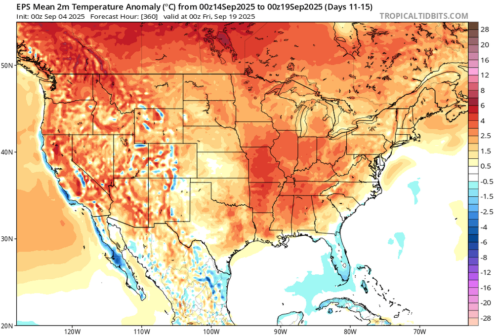
I guess this means the upcoming winter is cooked and torched. I had a below 161 ACE before the season even begun, and it was pretty apparent by mid-June. The better question now is if we're even going to hit half of 161 ACE. -
Fri/Sat rn turning into more of a showery kind of deal (shocking), maybe tshowers on sat, but frcst calling for ~0.25" won't do shit. We got 0.75" last Friday and that had almost no positive impact on soil conditions. wake me up when we're looking at a couple days of steady rn, preferably 2+"
-

2025 Atlantic Hurricane Season
BarryStantonGBP replied to BarryStantonGBP's topic in Tropical Headquarters
Thoughts on b2bs showing in models/ensembles? -
Area of disturbed weather in the eastern Atlantic is starting to organize. Finally something to watch. Would expect an invest later today or tomorrow. Safe re curvature is not a given. Some impacts to at least the eastern Caribbean islands mid next week seems pretty plausible. Beyond that ?
-

September 2025 OBS-Discussion centered NYC subforum
MANDA replied to wdrag's topic in New York City Metro
Area of disturbed weather in the eastern Atlantic is starting to organize. Finally something to watch. Would expect an invest later today or tomorrow. Safe re curvature is not a given. Some impacts to at least the eastern Caribbean islands mid next week seems pretty plausible. Beyond that ? -
Praying for rain.
-
I haven't been there in 30 years but one thing that's probably the same is the east side of the park is significantly more crowded. There's also a fair chance that it will be snowy over ~9k feet. It could be 95° in Boulder, 90 in Estes and 25 going over the top. The west side is (was) much greener and more peaceful.
-

September 2025 OBS-Discussion centered NYC subforum
MJO812 replied to wdrag's topic in New York City Metro
Still early -

September 2025 OBS-Discussion centered NYC subforum
Dark Star replied to wdrag's topic in New York City Metro
Sorry, this is how my brain works...
-
September 2025 OBS-Discussion centered NYC subforum
Dark Star replied to wdrag's topic in New York City Metro
There are many factors that go into Hurricane Season predictions, but the easiest is to assume that the ultra warm Gulf would enhance any system? Looks like the Hurricane season predictions will be wrong 2 years in a row? -
Fog machine working OT this morning here, currently 53.7/53.0.
-
First 30s of the season this morning here with 39.
-

2025 Spring/Summer Mountain Thread
Met1985 replied to Maggie Valley Steve's topic in Southeastern States
Had a low of 56 with guess what more rain this morning. -

Eastern Tropical Atlantic Wave - 50/80
GaWx replied to BarryStantonGBP's topic in Tropical Headquarters
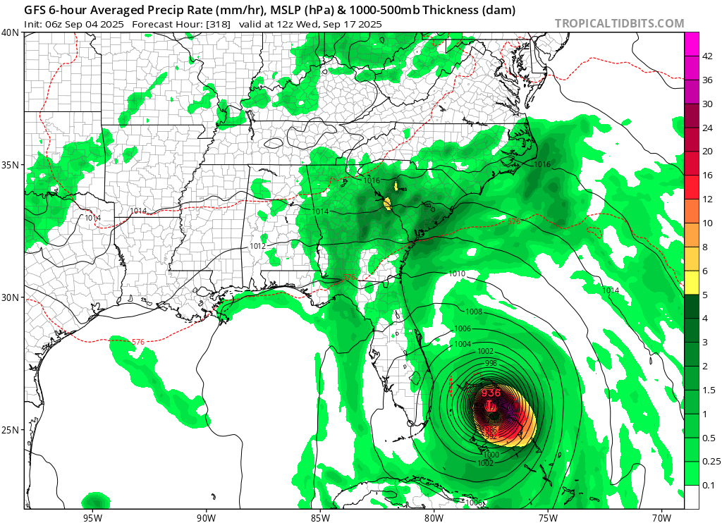
For the record, the 0Z Euro center stays just offshore S FL as it recurves to northward motion 100 miles offshore at 360. Of course, the 360 hour position on an operational has very little credibility. Only 3 of the 50 0Z EPS members come within 300 miles of S FL from this with none hitting there throughout the run. One out of 50 (2%) threatens to hit S FL from this system while still near Andros Island at 360. Another member develops from what looks like something else that’s moving NE from near S FL. -

Central PA Summer 2025
Mount Joy Snowman replied to Voyager's topic in Upstate New York/Pennsylvania
Low of 61. Rain chance this evening and again on Saturday, and then we get another taste of fall. Happy Thursday, y’all. -
16-17: Slightly below avg here but above for the immediate coast with the big early Jan storm 17-18: Avg/slightly above avg snowfall here; above avg for the coast> Da bomb cyclone in Jan 21-22: Above avg snowfall for much of the coastal plain 24-25: Above avg snowfall for much of the coastal plain Long term annual avg snowfall for my area is 18.5".. No idea what it actually is anymore, but probably anything over 16" is above.
-

September 2025 OBS-Discussion centered NYC subforum
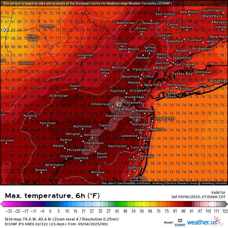
bluewave replied to wdrag's topic in New York City Metro
Looks like a back and forth pattern setting up this month. Next chance for low 90s at the usual NJ warm spots Friday into Saturday. Then cooler weather returns for next week with a warm up again in mid-September.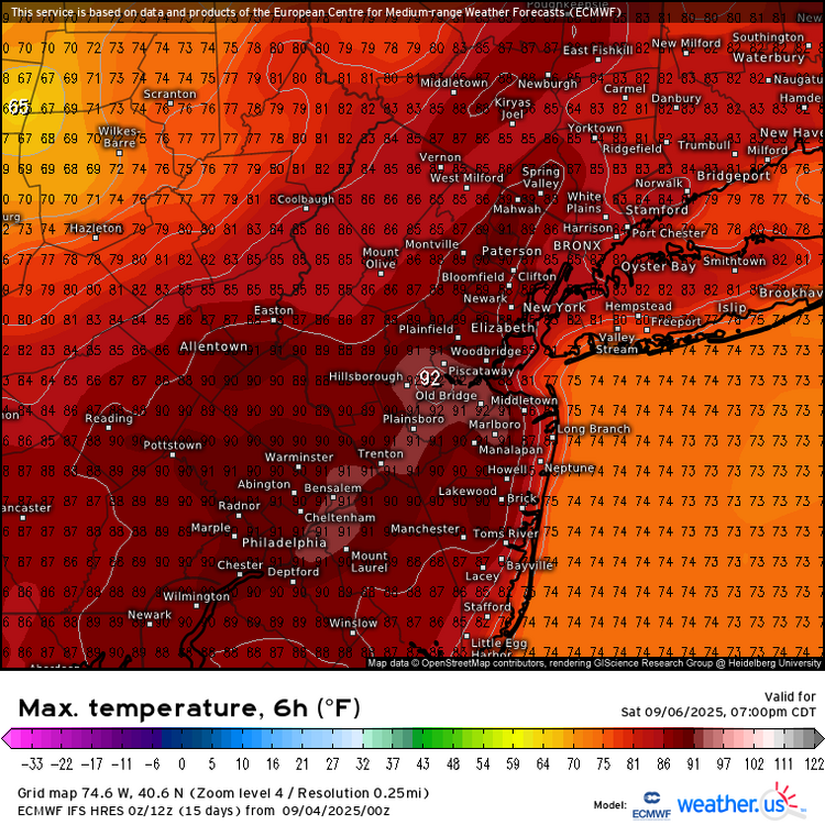

- Today
-

Eastern Tropical Atlantic Wave - 50/80
cptcatz replied to BarryStantonGBP's topic in Tropical Headquarters
00z Euro and 06z GFS are amazingly almost identical in the 240-360 hour range. Both crush the bahamas and then ride up the southeast coast. -
-
Eastern Tropical Atlantic Wave - 50/80
MJO812 replied to BarryStantonGBP's topic in Tropical Headquarters
Euro hits Florida Gfs is a tick south so far but still running.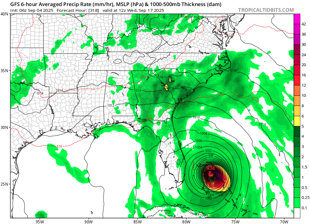
-
The big story in the Arctic last few summers has been the record warmth in the Kara and Barents seas areas with the very low sea ice extent there. https://alaskaclimate.substack.com/p/august-2025-arctic-sea-ice Regional Sea Ice The Atlantic side of the Arctic has had very low ice extent all summer, with the Barents and Kara Seas almost entirely open water for much of late July and August. The pack ice edge at the end of August was near 82N, 200 km or more north of the Svalbard and Franz Josef Land archipelagos. The climate impacts of the lack of ice were dramatic. The only real-time climate station in Franz Josef Land, Polargmo Im. E. T. Krenkelja on Heiss Island at 80.6N, did not record a temperature below freezing in August. At Wiese (Vize) Island, a small island in the northernmost Kara Sea at 79.5N, the temperature has remained above freezing since July 16 (47 days as of September 2). Last summer, the longest freeze-free period there was 11 days and in summer 2023 the longest was only 4 days. On the Pacific side of the North Pole, ice loss in the Beaufort Sea increased during August, but plenty of ice remained at the end of the month in the eastern part of the basin. The Northern Sea Route, along the north coast of Russia, was open to most vessels by late August. The Northwest Passage, connecting Canadian waters with the Bering Strait, was close to being open for non ice-hardened traffic, but mobile areas of higher concentration ice persisted at the end of August in Amundsen Gulf, the southeastern-most portion of Beaufort Sea.
-
Anyone have any insight on rocky mountain national park? Gonna be in colorado for a few days for a work thing in 2 weeks, most likely what we’ll spend our free time exploring i think.
-

Predict the name of the next major hurricane
baldereagle replied to BarryStantonGBP's topic in Tropical Headquarters
It will be called Barry GBP and will be a catastrophe on the forum. -
Gotta' give it to him. That's a whole lot of words for a non-forecast.
-
Gfs and GGEM really like Saturday now as well. Euro, as always, remains cagier.