All Activity
- Past hour
-

Central PA Winter 25/26 Discussion and Obs
Festus replied to MAG5035's topic in Upstate New York/Pennsylvania
Looking at the 0Z GFS, there's actually a shot we don't get above freezing for the entire run. The last time we were above freezing here was Friday the 23rd. So if true, that would realize a stretch of 24 consecutive days below freezing obliterating the previous record of 15 straight days. We better have a nice Spring after this! "The longest consecutive stretches of temperatures remaining below freezing in the Millersville/Lancaster County area are 15-day periods, occurring from Feb. 5–19, 1979, and Jan. 20–Feb. 3, 1961."

-
 Dropped 10 degrees in about 25 minutes. Checked a few PWS and they all show the same when winds switched NW.
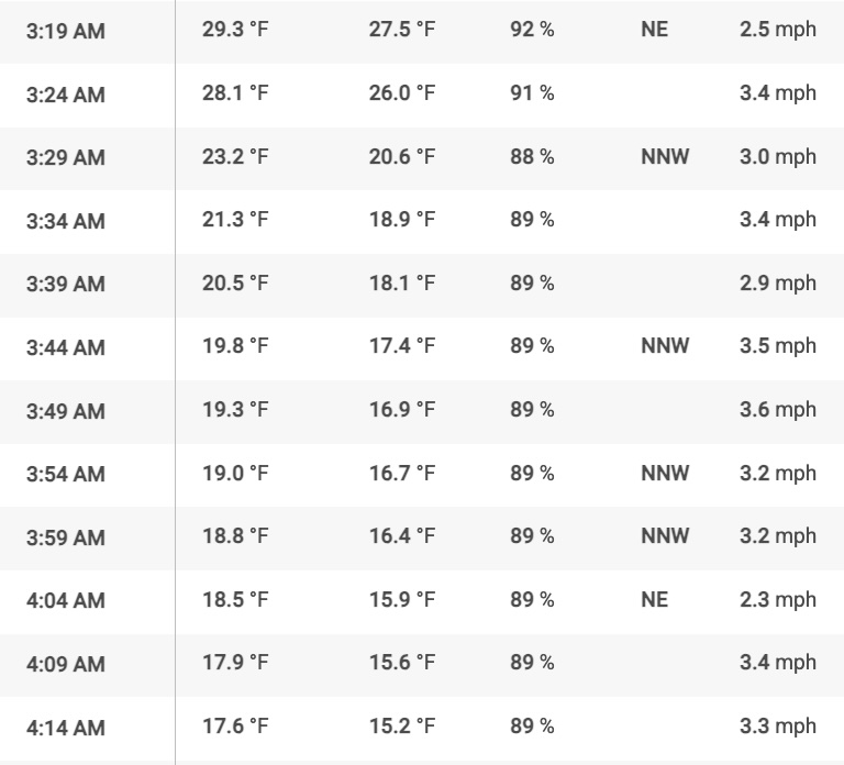
-
That have something to do with where the PNA ridge will be?
-
Light snow, another coating on top of what fell. I’ll go with the 11” others in my area have since it was tough to measure and I think some blowing snow/stuff got onto my table I use to measure. What a mess. I wonder what liquid equivalents people have?
-

1/24-1/25 Major Winter Storm - S. IL, IN, and OH
RobertSul replied to A-L-E-K's topic in Lakes/Ohio Valley
I moved to southeast Michigan a number of years ago from central Mass, where we’d often get more snow than Boston because of less coastal taint and some amount of orographic lift. It’s been tough seeing some of their best winters since I’ve moved here, and I still stupidly believe the long range models that show 12”+ around here because that was always a reality out there. If it make you feel any better, tracking these monster storms is fun, but the reality of digging out isn’t. I had to dig a path in the backyard for the family dog growing up when an April 1st storm dropped nearly 3 feet of cement snow practically overnight, and our German Shepherd couldn’t plow through the snow to pee, and the snow was too dense for the snowblower to chew through. Spent a good 4 hours or so shoveling that day. -
Including the sleet, I end up with 11" from this. Which is in line with nearby obs. Crazy event.
-
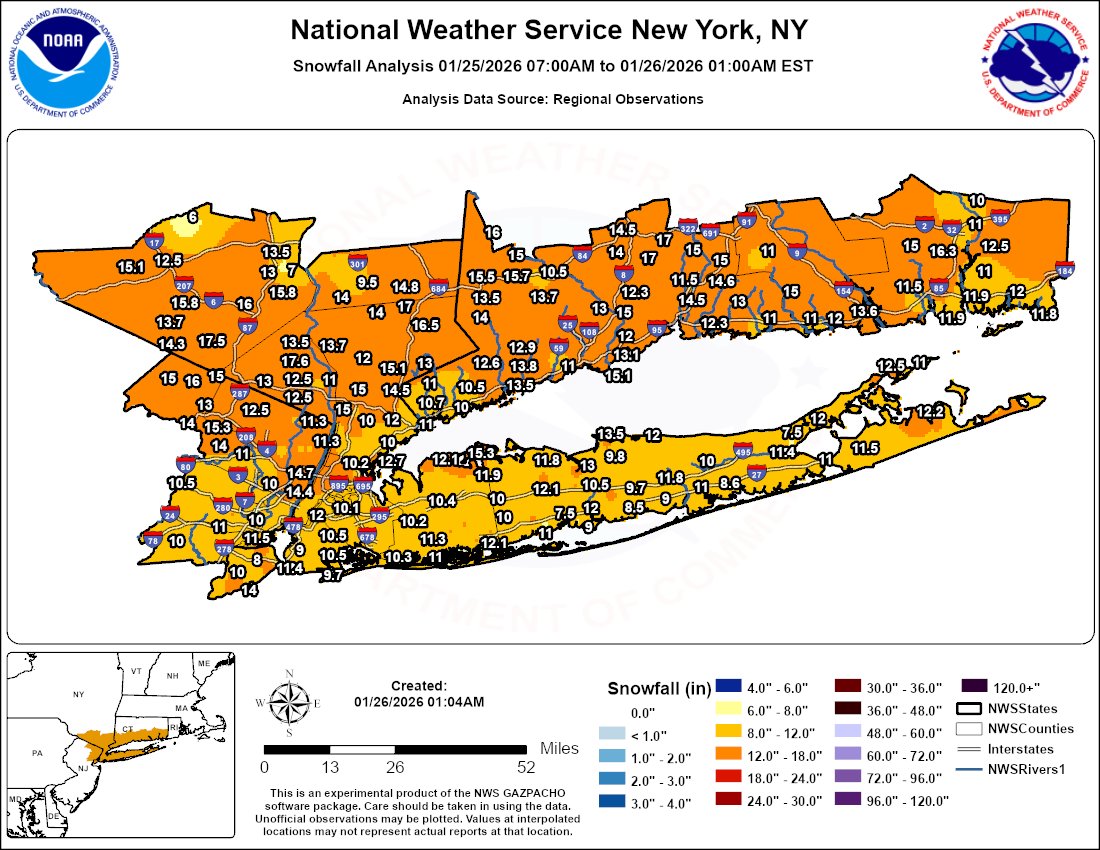
1/18: 1” 1/25: 8.5” Season Total: 18.8”
-

January 2026 regional war/obs/disco thread
jlauderdal replied to Baroclinic Zone's topic in New England
We make a run at 90 today and then we can start thinking about snow in South Florida. Been here 30 years, never seen 7 straight days below 70 but we are heading that direction. Congrats on turning lemons into lemonade with this last system, and looking good for another next week. -
 Round 2 looking solid today
 -
January 2026 regional war/obs/disco thread
Damage In Tolland replied to Baroclinic Zone's topic in New England
We are back -
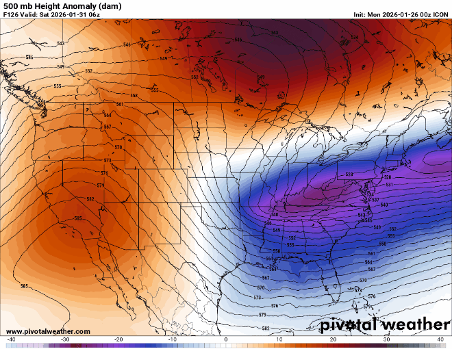
Looks like the trough/sw is backing west, eliminating some OTS possibilities. But we'll just have to see how far west it backs until they hone into something that's close to a solution. The storm yesterday - the NS wave and the phase kept backing west for days, and for a couple days it was at the sweet spot for us, and then it still kept backing west.
-
Not there, but headed in the right when comparing 0z to 6z.
-
Hours and hours of mist at 14° did a good job of locking in whatever wasn't shoveled. Fugger, this sux to shovel Now it's snowing lightly and covering everything again too.
-
Was more interested in a final report from Newport. Around 12?
-
 13 inches Branford.
-
 Just measured 3 spots.. 16,16,17 im sure it compacted some and not sure how accurate with the blowing snow around
 -
 Just walked the dog.....my street is entirely a drift. Not surprisingly, my deck is entirely snow-free. I think all the snow that had come down on the river-sde of the house has been relocated to the front and to other's houses up the street. Fun little storm.
 -
I am up to 22.5 inches for the winter.
-
Temp falling 23F Pressure rising 29.60 Final freezing rain total according to the weather system .42"
-
dude they never plowed gregg hill It's still 1 ft of snow But so light and fluffy it's delightful I will share video, but I have lived here since 1987. I have never seen a road as unplowed as this, well closed class 4 maybe. They never made a pass today at all
-

E PA/NJ/DE Winter 2025-26 Obs/Discussion
Albedoman replied to LVblizzard's topic in Philadelphia Region
This would cause this biggest G dam flood and end in chance of a drought for a year. 96 all over again. I am done with snow for awhile. A federal disaster would have to be issued and the resulting melt and thaw with any rain over a couple of inches would blow out every fricking bridge on the Delaware. Next big worrk folks other than this BS run of the Euro, ice jams. The base flows are low in the streams, nearly 2ft of snow on the ground north of S Mtn and 3-5 days of below zero weather and highs not even cracking 26 degrees. The Delaware, Lehigh and especially the Susquehanna are frozen over now or close to it. The media is going to go crazy. I did not say Schulkill because the cooling waters from the industrial treatments plants from Limerick ,Oaks and Reading may keep the water warm enough in that river from freezing over. -
My cous received 25,5 in pearl river nice .
-
Icon might of been trying to do naught things
-
Yeah, next weekend looks like another system with the Euro AI taking the lead. It had this weekends system coming up the coast while the OP Euro and EPS and GFS and GEFS were too suppressed. The GFS and GEFS were the most suppressed. The EPS-AIFS and AIFS single were first showing next weekends system more defined and just offshore last few days while the OP Euro and EPS and GFS were more suppressed. The 0z guidance now has the ridge and trough axis further west allowing the trough to go negative tilt quicker for the benchmark Miller A Southern Stream KU potential. It would be wild if the 10 year major KU snowstorm pattern in January 1996, February 2006, January 2016, and February 2026 worked out. EPS-AIFS and AIFS single are now the highest scoring models