All Activity
- Past hour
-
Low end warning here
-

Pittsburgh/Western PA WINTER ‘25/‘26
colonel717 replied to Burghblizz's topic in Upstate New York/Pennsylvania
INSANE next weekend possibility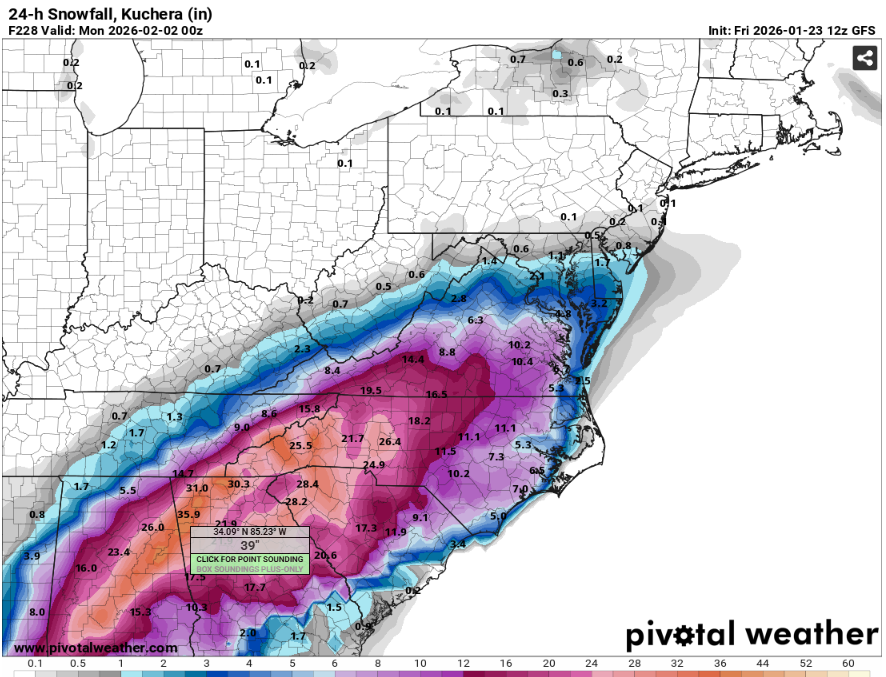
-

MO/KS/AR/OK 2025-2026 Winter Discussion
MUWX replied to stormdragonwx's topic in Central/Western States
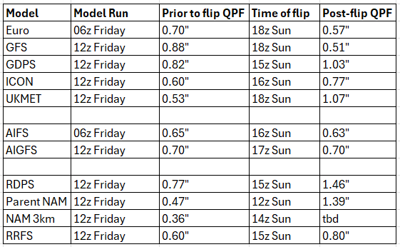
Its probably too late in the game to really be looking into global models, but it is interesting to me that the UKMET has pretty much completely folded and now has a solution very similar to the GFS. Last night the UKMet had .5" all the way to KC and now it barely gets it to I44. Canadian is pretty similar. It wasnt as far north as the UKMet initially, but they are both settling on I-44 being the cut off. -

Pittsburgh/Western PA WINTER ‘25/‘26
Ahoff replied to Burghblizz's topic in Upstate New York/Pennsylvania
Is anyone concerned we don’t get as cold tonight and tomorrow since we don’t have really any snow pack? -
It's an absolute crusher of a storm for us.. (not the midweeks thing obv)
-
Updated version
-
Crazy how it keeps showing it 10 days out
-
Just had a quick burst of sleet in downtown Raleigh.
-

Possible Record Breaking Cold + Snow Sunday 1/25 - Tuesday 1/27
jlauderdal replied to TriPol's topic in New York City Metro
Don't trust kuchera, ratios are higher in this setup -

Snow Contest January 25th-26th
WeatherGeek2025 replied to WeatherGeek2025's topic in New York City Metro
New York City 14 Boston 18 Philadelphia 11 Washington DC 10 Hartford 16 Albany 14 -
New York City 11 Boston 14 Philadelphia 10 Washington DC 9 Hartford 13 Albany 15
-
234 the SLP is down by ILM still?
-

“Cory’s in LA! Let’s MECS!” Jan. 24-26 Disco
40/70 Benchmark replied to TheSnowman's topic in New England
How did it trend from 00z? -
Gfs with a coastal snowstorm on February 2nd.
-

January 2026 Medium/Long Range Discussion
NorthArlington101 replied to snowfan's topic in Mid Atlantic
Not close to over yet but it's a NESIS 5 kind of thing -

Possible Record Breaking Cold + Snow Sunday 1/25 - Tuesday 1/27
SnoSki14 replied to TriPol's topic in New York City Metro
They'll probably go 8-12 when warnings come out -
The UK ptype maps had a glitch...shows snow in places that are clearly above freezing at 850 at 15z Sunday. It still has a good thump legit for the area, 6-8" from what I can tell DC north to PA line... but the maps have to be thrown out because its not calculating precip type correctly
-
Post snow map if you could? So I can send to my wife and she’ll think it’s for this weekend.
-
There's still time as the players are being sampled better.
-
Ukie is pretty much 15’’+ region wide with lollis to 24’’ on the south shore. Sweet run.
-

January 25/26 Jimbo Back Surgery Storm
StantonParkHoya replied to Jimbo!'s topic in Southeastern States
RAP almost looks like sleet in higher intensity bands and ZR in lower ones . -
Literally has a Blizzard looking at the wind and low pressure.
-

Possible Record Breaking Cold + Snow Sunday 1/25 - Tuesday 1/27
NEG NAO replied to TriPol's topic in New York City Metro
probably taking into account the city environment itself and the traditionally low snow measurements in CP. -
Run it back?
-
I'm really interested in this one. GFS wasn't as enthused as it was at 6z


