All Activity
- Past hour
-
Forecast of storms / rain tomorrow already cut down to 60% from 80% this morning. Another dud incoming.
-

2026-2027 Super El Nino
Stormchaserchuck1 replied to Stormchaserchuck1's topic in Weather Forecasting and Discussion
Another Aleutian ridge! Since the El Nino began, N. Pacific ridge vs troughs lasting 5 days more more: 6-0. July will likely be the 6th consecutive month of -PNA -

Mid-Long Range Discussion 2026
WinstonSalemArlington replied to BooneWX's topic in Southeastern States
-
We got a letter to stop watering immediately. Then they reversed the decision and said that was only for the Hamptons. Now for us it’s odd/even day stuff.
-
2026-2027 Super El Nino
Stormchaserchuck1 replied to Stormchaserchuck1's topic in Weather Forecasting and Discussion
I've always wanted to do that. In Mt. Shasta, CA the mountain clears completely in the Summer, then in September/October huge amounts of snow start piling up on the top. How cool would it be to camp on top of that mountain when the first 4-8' falls? It's easy to climb to. -
 And this not far over the ME border in 1825? One of largest wildfires in NAMR history. https://en.wikipedia.org/wiki/1825_Miramichi_fire You go back far enough in recorded history, you see that massive events are not as unusual or atypical as they may seem.
 -
recent days have demonstrated how smoke vs clean air can lower ground-level air temperatures
-

2026-2027 Super El Nino
Jebman replied to Stormchaserchuck1's topic in Weather Forecasting and Discussion
Man I wish they had a live webcam - They make Mammoth Ski Resort look like the DMV in a La Nada winter. I am SOOOOOOOO damn Jealous of all their snow. I'd love to kick back on a Texas lawn chair on their ski parking lot and watch that snow pile up all around me lol. -
The smell of the gas in Taco Bell’s bathroom is worse than this. Man up.
-

July 2026 General Discussion
SchaumburgStormer replied to Chicago Storm's topic in Lakes/Ohio Valley
2 miles due east of me at the dirt track got down poured on to the point they had to cancel races for tonight -
I find the argument “I lived through worse AQI and we still had events” so weird. Back then, we didn’t how bad it was for you and it was normalized so of course you held events in air which damaged your lungs, you didn’t know better! Now we do, so correspondingly we cancel. It’s like complaining that people wash their hands because we learned germ theory!
-
 It was nice to have the clean air today. It will be interesting to see how much smoke comes back tomorrow and how it interacts with the convection potential over the northeast tomorrow. Maybe it's a good lesson for future modeling. Not to get into politics but I just saw that Trump is threatening Canada with tariffs to get it's s..t together. Perhaps climate changer deniers have more to do with it than vast boral forest management?
 -
AQ improved to 211 here. Wonder if we’re actually going to get a break from this, it was supposed to be moving out this afternoon but it still looks hazy as hell.
-
The rain is still very much needed. Town of Huntington started water restrictions where odd/even numbered addresses can water their lawn on odd/even number days.
-
WB latest EURO weeklies now go through the end of August.... warm and only wet in the mountain areas.
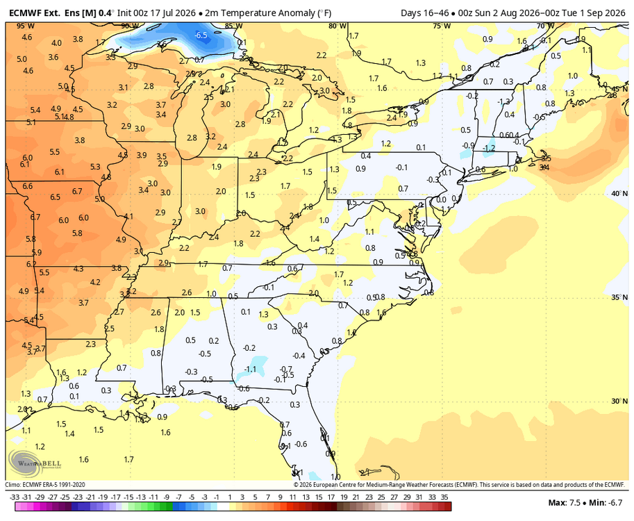
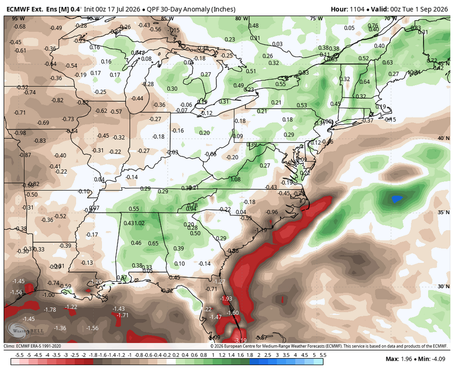
-
2nd day in a row of 89 Didnt qualify as heatwave with just 91 and 97 earlier in week Smoke was barely noticable this morning and beautiful sun this afternoon
-
2026 Atlantic Hurricane Season
vortex95 replied to Stormchaserchuck1's topic in Tropical Headquarters
Dang! That's quite a swirl, but largely at mid-levels. it looks like it is detaching itself from the main 500 low. We could see pinwheeling small LLCCs if the convection collapses completely. -
2026 Atlantic Hurricane Season
vortex95 replied to Stormchaserchuck1's topic in Tropical Headquarters
A good part of the FL PH could use the rain! - Today
-
I think thick smoke can go both ways. On Tue, big time svr wx (best SCP and SIGTOR parameters I have seen in a long time in the Northeast), was completely squashed during the daylight hours at least. Otherwise there would likely have been a sig tor event in srn Quebec and nrn New England. Temps were held down a lot. BOS fcst high as 97, and high was only 90. PWM fcst high was 93, and only got to 85. This resulted in CINH remaining stronger over the entire area. However, ydy we saw a nasty back-building tstm training event in cntrl NJ. Wind gusts as high as 84 mph at Surf City and they also had 4.37" of rain. CG LTG was incredibly dense in a narrow swath. And these storms fired directly within the thick plume of smoke. One can say w/ high confidence the smoke in the Northeast was the cause for the svr wx bust here, but for what happened in NJ ydy? Not as clear. That would be a good case study/research item, re-run models w/o the smoke, and see if intense tstms would have occurred to the degree they did! The models for tomorrow have smoke in their initialization, unlike what happened on Tue in the Northeast, so it is accounted for. I am not impressed w/ the 18z HRRR storm coverage tomorrow over the region. 18z RRFS is a little better, and shows an isolated honkin' supercell just N of DC, but the 45% area for wind seems high for the DMV area to me given the *coverage* of storms fcst. This is important. The colored SPC outlooks areas are for expected svr wx type coverage, they say nothing about how intense any individual svr wx may be (the hatched areas show that) So they should be solid svr storms, just the real question is coverage overall. The thick smoke may be a factor here, but how much in either direction? We go from weak anticyclonic flow aloft today to solid cyclonic flow tomorrow w/ a s/w coming thru. 500 heights come down as well. But the NAM shows 500 temps actually increase a bit in the aftn, up to -4 C (yuck!). The GFS tho shows slight cooling from -5 C tdy to -6 C tomorrow. Also, the mid-level lapse rates are not as bad as you would think for such warm 500 mb temps. Looking at the NAM and GFS, it shows lapse rates as high as 7 C/km on the fcst soundings (not using 700-500 exactly here, any thick layer at mid-levels will do). Fcst K-indices in the area gets as high as 40 on both the NAM and GFS, and that is impressive. Juiced column for big rains! NAM has PWATs are high as 2.8" which is likely overdone. GFS has it as high as 2.5" which is good for this model (not usually that high)! Anything over 2" is more than enough. Since DCAPE is fcst high and 0-3 km CAPE low, tor threat seems minimized. 0-6 km shear 35-40 kt, so enough for supercells.
- 1,038 replies
-
- 2
-

-

-
- severe
- thunderstorms
- (and 7 more)
-
Stms moving through. Rains helping clear the air. Very nice break
-

2026 Atlantic Hurricane Season
marsman replied to Stormchaserchuck1's topic in Tropical Headquarters
I bet they're gonna fly: -
 Not as visible the last couple of years but you can still see traces.
 -

2026 Atlantic Hurricane Season
Prospero replied to Stormchaserchuck1's topic in Tropical Headquarters
COD: Satellite and Radar (Friday July 17, 2026 at 17:56 PM EST)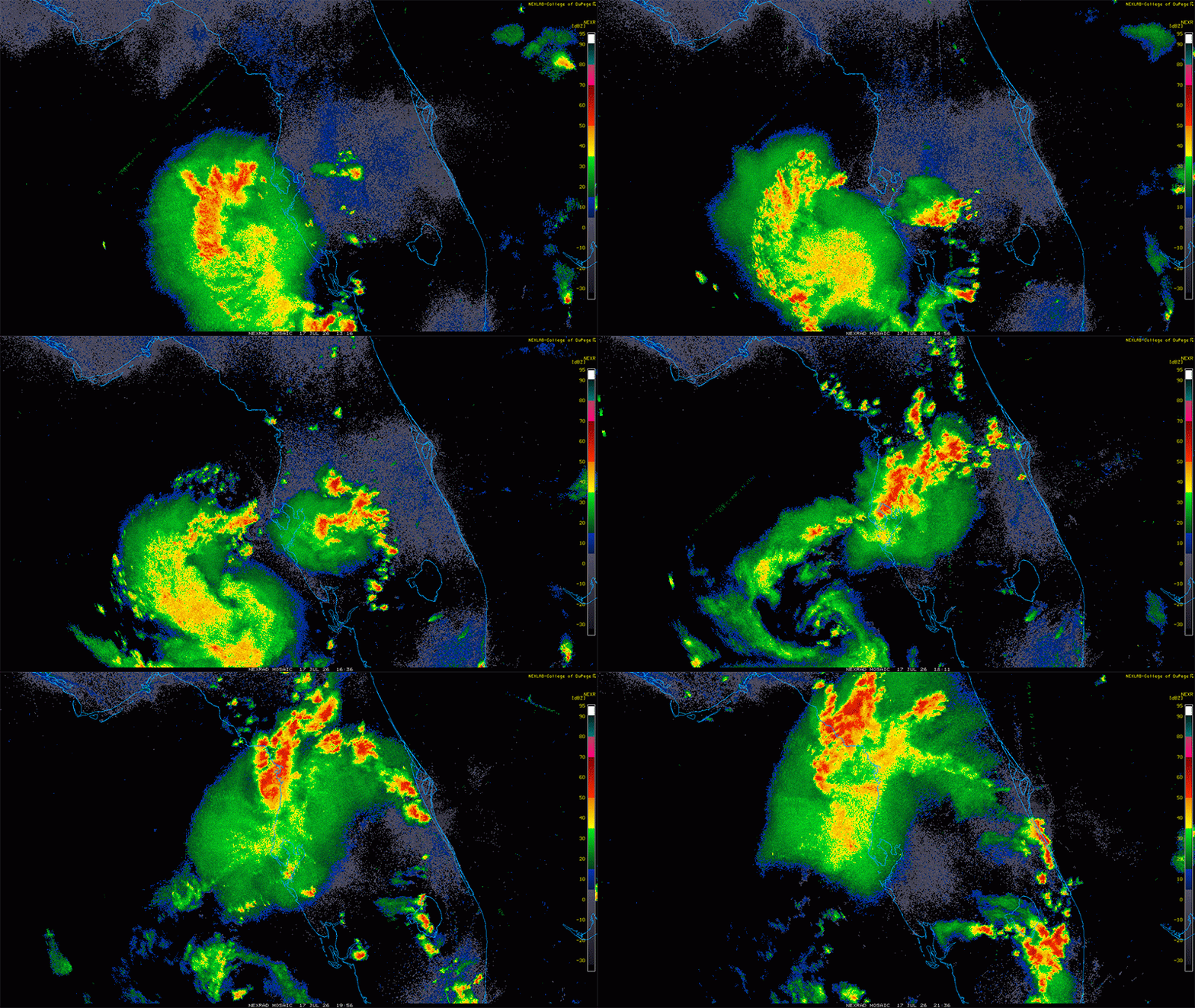
-
The smoke today smells worse than usual. The smoke I remember out west was a straight campfire smell. This smells like campfire mixed with New Jersey (a mix of burning rubber and bad BO).
-
2026 Atlantic Hurricane Season
Prospero replied to Stormchaserchuck1's topic in Tropical Headquarters
As far as Gulfport, FL, this has already been the most exciting weather event since Milton.