All Activity
- Past hour
-
49 here
-

The return of the elusive Nor'easter. Drought buster or bust?
WxUSAF replied to dailylurker's topic in Mid Atlantic
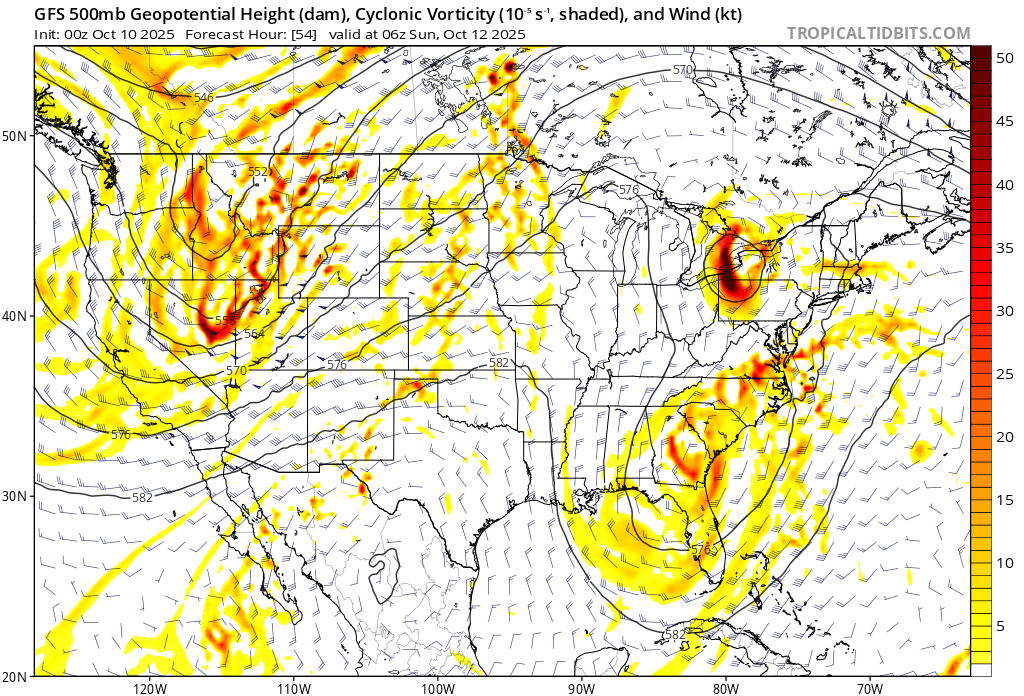
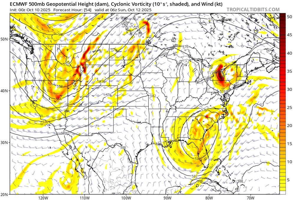
There’s sort of two parts to this. The first is tomorrows afternoon into early Sunday with a deformation axis between the developing coastal and the northern stream shortwave. That seems fairly uniform on guidance? Then the second part is rain from the coastal. That still is uncertain and overnight runs definitely lowered the odds of the big 1”+ amounts. -

Spooky Season (October Disco Thread)
HoarfrostHubb replied to Prismshine Productions's topic in New England
29.2F here A lot of 27 and 28 in my immediate area. -
I caved, flipped the heat on just now, it was 59 downstairs. 29 degrees and still dropping, can I get to 28...
-

The return of the elusive Nor'easter. Drought buster or bust?
snowfan replied to dailylurker's topic in Mid Atlantic
6z NAM is comical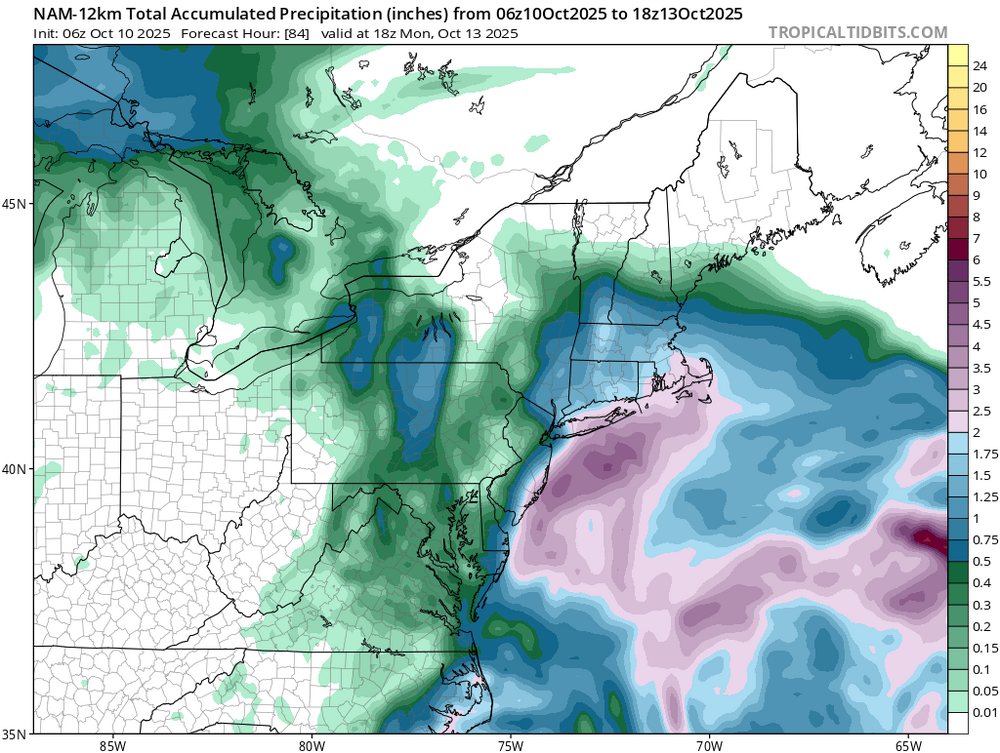
-
Yes, 29 here, just down the road from there currently. KMGJ is a good radiation spot.
-
37F in Hastings.
-
The return of the elusive Nor'easter. Drought buster or bust?
snowfan replied to dailylurker's topic in Mid Atlantic
Oh the heartache if this were winter.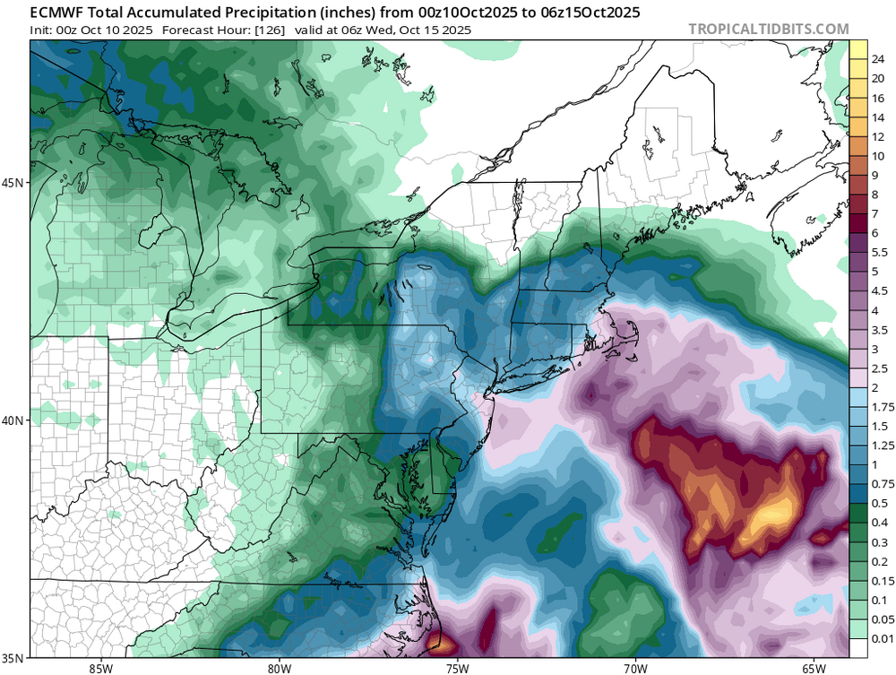
-

Spooky Season (October Disco Thread)
Sugarloaf1989 replied to Prismshine Productions's topic in New England
30F here just before dawn. Went straight past first frost to sub freezing. -
last 2 nights did not get as cold in the city as was predicted..
-
days n days
-

The return of the elusive Nor'easter. Drought buster or bust?
Eskimo Joe replied to dailylurker's topic in Mid Atlantic
We always want the capture and tilt to occur as far to our southwest as possible. Otherwise we're living on the edge, and that's not good. -
Currently 34 at the Mesonet. 38 at my house
-

Spooky Season (October Disco Thread)
Lava Rock replied to Prismshine Productions's topic in New England
38f. Fake cold. Colder yesterday Sent from my SM-S921U using Tapatalk -

Central PA Fall Discussions and Obs
pawatch replied to ChescoWx's topic in Upstate New York/Pennsylvania
Bad week for Pa.sports! 29 degrees first frost of the season. -

E PA/NJ/DE Autumn 2025 Obs/Discussion
LanghorneSnow replied to PhiEaglesfan712's topic in Philadelphia Region
Okay, now you post a pic of yourself, and we can all compare. now, back to the weather! -
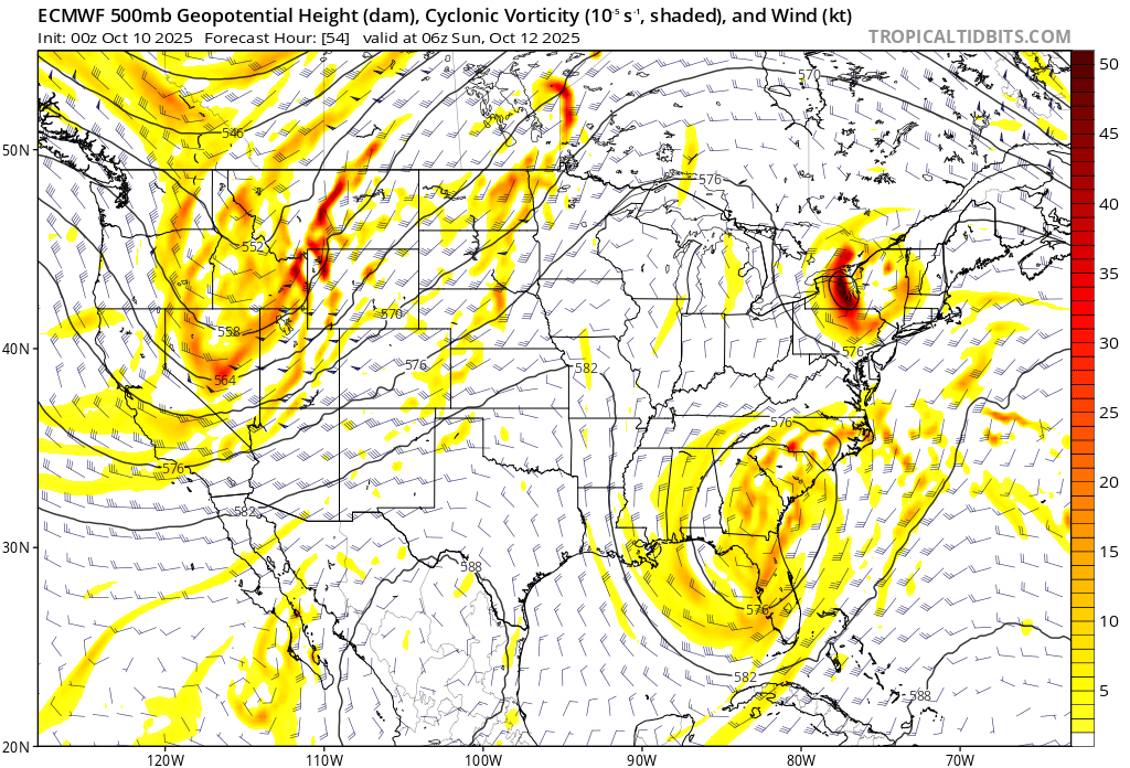
Also euro guidance takes that s/w over the lakes and moves it over us which blocks how far north it can get. My gut says that the main issue is keeping this further south and helping to reduce impacts, but still time i guess.
- Today
-
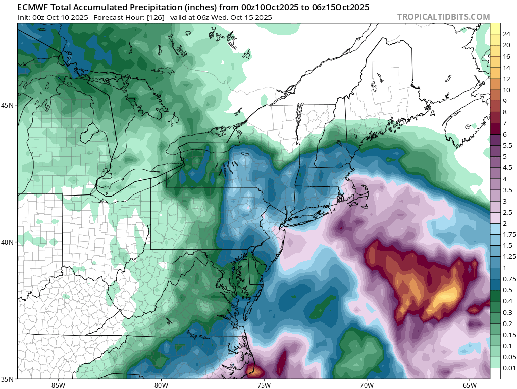
Gfs is a good hit. Not sure why everyone said it’s south. Euro and AI and NAM redevelop it south of New England and then rip it back west like some guidance showed yesterday. Definitely not in agreement with the interaction of a piece of moisture NW of Jerry. Need to get euro and AI more north for anything real meaningful I think. NAM is high impact, but when is it not lol.
-
5am temp here is 37 on top of the hill. Pequest, Sandyston and Walpack up in NW Sussex 28, 28 and 25 respectively. Mid 30’s down in the Pine Barrens. Ideal radiational cooling with low lying rural locations cashing in on coldest temperatures.
-

The return of the elusive Nor'easter. Drought buster or bust?
CAPE replied to dailylurker's topic in Mid Atlantic
There are differences in timing/location of the northern stream vorticity digging southeastward from the GLs. GFS involves it more and sooner than the Euro. Seems to capture the southern piece of energy, encouraging a more consolidated surface low with a track more westward.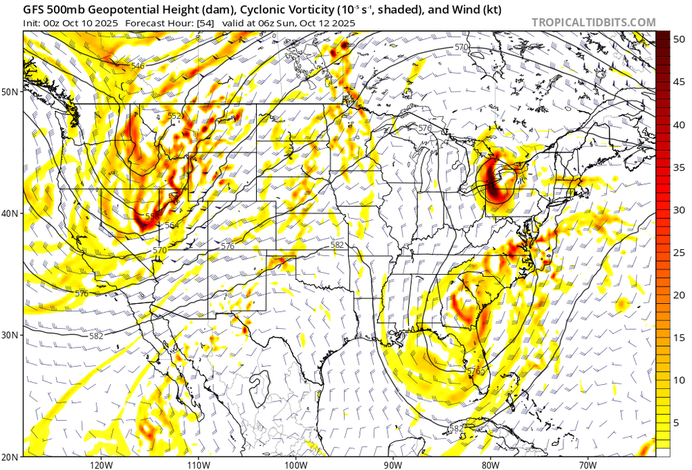
-

The return of the elusive Nor'easter. Drought buster or bust?
Weather Will replied to dailylurker's topic in Mid Atlantic
Well, the Euro remains the King....
-
Montgomery: 28.
-

Spooky Season (October Disco Thread)
ineedsnow replied to Prismshine Productions's topic in New England
Down to 25 we take! -
The mid-month cool shot is basically up in smoke now. Relentless AN with a deeply BN west looks like it's going to be the basic pattern for at least a few more weeks.
-

The return of the elusive Nor'easter. Drought buster or bust?
MillvilleWx replied to dailylurker's topic in Mid Atlantic
This is becoming a legit option on the table. Doing the QPF tonight, that was evident. AIFS continues to have a theme of a split SLP with a primary near NC with a secondary to the northeast over the Gulf stream, occluding moving westward before weakening. There could be a QPF min between the evolution, so something to monitor closely. Winds are going to be there regardless, so the coast will get battered no matter the evolution.