All Activity
- Past hour
-
Rainbow weather pop up showers as the ULL spins around
-
First week of June has potential to be quite warm
-
womp womp definitely not as cool as its been and should get a bit more humid though.. but nothing crazy yet Late This Week / Next Weekend: Still a little uncertain when it comes to the day-to-day specifics but as 500 mb ridging transitions to one of longwave troughing, this looks to be yet another unsettled late-week/early-weekend weather pattern as we close out the month of May. Kept PoPs in the Chance range given 500 mb trough axis to our west; though it won`t be raining the whole period of time, there could be a few opportunities at showers/possible storms with southerly flow offering a rather moist airmass. Temps should continue to run around or just above seasonable to close the month, but then start to cool off and we may start the month of June with temps running cooler than normal.
-
Nice, we had a mini airshow here too. Marine One and a couple Osprey for Trump in Bedminster. They shake the house every time.
-
I'm sitting outide, smoking a little weed (I don't drink), drinking some cold brew and listening to music. Life is good sometimes.
-
I feel for you. That's brutal...
-
It will be partly sunny and even milder tomorrow. Temperatures will top out in the upper 60s. Readings will warm further into the lower 70s on Memorial Day. Nevertheless, temperatures will remain somewhat cooler than normal. The below normal temperatures will likely persist into the middle of next week. However,it could turn noticeably warmer during the closing days of the month or opening of June. The ENSO Region 1+2 anomaly was 0.0°C and the Region 3.4 anomaly was +0.1°C for the week centered around May 7. For the past six weeks, the ENSO Region 1+2 anomaly has averaged +0.55°C and the ENSO Region 3.4 anomaly has averaged -0.07°C. Neutral ENSO conditions will likely continue through at least mid summer. Early indications are that summer 2025 will be warmer than normal in the New York City and Philadelphia areas. The potential exists for a much warmer than normal summer (more than 1° above normal). The SOI was +23.38 today. The preliminary Arctic Oscillation (AO) was +1.533 today. Based on sensitivity analysis applied to the latest guidance, there is an implied near 56% probability that New York City will have a cooler than normal May (1991-2020 normal). May will likely finish with a mean temperature near 63.0° (0.2° below normal).
- Today
-

E PA/NJ/DE Spring 2025 Obs/Discussion
KamuSnow replied to PhiEaglesfan712's topic in Philadelphia Region
Had a couple of brief showers here, looks like another about to roll in. It goes from sunny and beautiful out to dark clouds and breezy with a shower, then back to sunny. -

Central PA Spring 2025
Itstrainingtime replied to canderson's topic in Upstate New York/Pennsylvania
More rain today than yesterday despite a dry forecast. 0.00" here yesterday and 0.02" so far today. Nice little shower rolled through around 4:30. -
Not his wedding . Just barely met the new girlfriend
-
Wonder who the lucky guy is.
-
Same. If not, congrats @TauntonBlizzard2013
-
Partly cloudy to mostly sunny and mid 60’s right now. People in shorts and t-shirts. High of 68, low of 47. Turned out better than I was expecting today.
-
 Malzed87 joined the community
 -
Wait I didn’t make the connection. He getting married again? Thought it was for a friend.
-

Mountain West Discussion
mayjawintastawm replied to mayjawintastawm's topic in Central/Western States
This is possibly the smallest severe thunderstorm watch I've ever seen. Pretty cool out now, though humid, doesn't feel like a severe weather day, though there's one supercell out near Kiowa (Kiowa has a semi-permanent supercell, I think).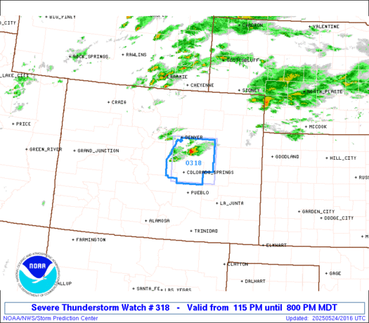
-
Wow. That horse really should have gone into a basement. I thought you lived near Jerry Seinfeld. well anyway, here's the radar
-
Partly sunny here but had a quick shower. 61 now. Feels more like mid April.
-
URGENT - WEATHER MESSAGE National Weather Service Baltimore MD/Washington DC 112 PM EDT Sat May 24 2025 MDZ509-VAZ503-WVZ501-505-250115- /O.NEW.KLWX.FR.Y.0005.250525T0500Z-250525T1300Z/ Western Garrett-Western Highland-Western Grant-Western Pendleton- 112 PM EDT Sat May 24 2025 ...FROST ADVISORY IN EFFECT FROM 1 AM TO 9 AM EDT SUNDAY... * WHAT...Temperatures as low as 34 will result in frost formation, especially in valleys. * WHERE...In Maryland, Western Garrett County. In Virginia, Western Highland County. In West Virginia, Western Grant and Western Pendleton Counties. * WHEN...From 1 AM to 9 AM EDT Sunday. * IMPACTS...Frost could harm sensitive outdoor vegetation. Sensitive outdoor plants may be killed if left uncovered. PRECAUTIONARY/PREPAREDNESS ACTIONS... Take steps now to protect tender plants from the cold
-
Real old at this point. Been teased with some brief blue sky and hints of sun, but showers move back in Sent from my SM-S921U using Tapatalk
-
Another dark overcast day 8C/43F, first rays of sunlight briefly in about 100 hours early in aft. This is the shittiest May 18-24 I've ever lived through!
-
43.0 low here after a 59.8 high. Sun came out and warmed us to 68 earlier, but the clouds and wind have returned in last 2 hours. Currently 65.5/37.6 with a NNW wind at 11 gusting to 19 mph. The 59.8 set a new record 'cool max' for the date breaking 2017's 60.2 degree reading.
-
hopefully it cleared up for you now. the winds are blowing the clouds away lol
-
wow how loud is that? it must be absolutely amazing to be there!
-
nice, did you guys clear up around 2:30 too?
-
What clouds lol