All Activity
- Past hour
-
Everything before Sunday’s partly cloudy/rain/dusting/blizzard
-

Another Coating of Snow Saturday - "It's all we Got"
Sey-Mour Snow replied to Sey-Mour Snow's topic in New England
GFS continuing its ridiculous as of late.. has a warning event for parts of ct and mass Saturday -
What is the 16-18 thread for, I thought it was the weekend storm.
-
We had around 1/2 inch this morning above about 1600 feet, around 8ish. Ended up causing school to be canceled.
-

2025-2026 ENSO
donsutherland1 replied to 40/70 Benchmark's topic in Weather Forecasting and Discussion
I suspect that the UHI Effect plays a role. The dandelions aren't exposed for the kind of long periods to severe cold that they are in colder less urban areas. -
GFS wants to bring us some snow tv tomorrow midday
-
I’m withholding excitement until the euro hops onboard. Temps still scare me but rates like NAM had with cold 925 would do the trick
-
I thought it was everything through this weekend but everyone is all over the place.
-
Yep most likely 1-3 inches
-
Webb still honking the horn saying he’d feel good if you’re in NEGA, WNC, SwVA. But, I need to see the models say so tonight/tomorrow
-
What are we tracking in this thread?
-
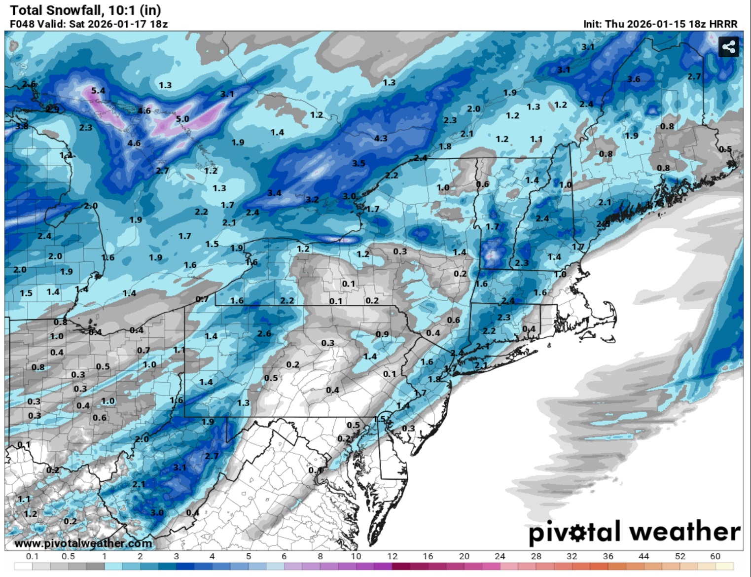
Long range HRRR for Saturday.

-

Winter 25/26 General Obs
Holston_River_Rambler replied to Holston_River_Rambler's topic in Tennessee Valley
Managed to get a few pics of the band as I drove home: I 81 southbound near mm 56 Looking SW from intersection of Wilcox Dr and John B Dennis: I don't think this was an optimal time, but there was some precip in the area the band sets up. Also @Carvers Gap: I may have brought some washing machine bad luck back to Morgan County, lol: -

Storm potential January 18th-19th
Brian5671 replied to WeatherGeek2025's topic in New York City Metro
Better model than the NAM or GFS so I'll listen.... -

First Legit Storm Potential of the Season Upon Us
weathafella replied to 40/70 Benchmark's topic in New England
Reggie is like Brady Anderson. One big season. 11 years ago -
Correct and got the Nam replacement that is a solid hit.
-

January 2026 regional war/obs/disco thread
dendrite replied to Baroclinic Zone's topic in New England
Wow what a winter. Raised my grade to a B for now Over to all snow since this vid finally uploaded IMG_7738.mov -
-

Storm potential January 18th-19th
Franklin0529 replied to WeatherGeek2025's topic in New York City Metro
This threat is done. Icon is wayyy east. I want what the rgem is smoking -
This is what I was suggesting to @Daniel Boone. With the coastal idea kind of exiting...I wonder if the end result is a more enhanced cold front w/ some small waves riding it? RGEM sure looked that way....And that makes sense given the strength o the cold front.
-
Could not agree more. The wishcasting and delusions going around twitter, even by some pro mets like Steve D is off the charts. This fantasy that we are about to see an instant light switch flip to a full on El Niño/+PDO pattern due to one WWB is completely ludicrous and absurd. Asinine. We are well into a 2nd year La Niña and over a decade of -PDO and majorly -ENSO events. The idea that there is going to be an instant, magical 180 degree flip of the PAC due to one WWB, is going to go down in flames. On a side note, this unexpected big EWB with the SOI positive surge has done some damage. The rapid upwelling was pretty impressive. Region 3.4 is still down below -0.8C on OISST, the lowest of this entire event and there are very pronounced tropical instability waves showing up throughout region 3.4 on the new SSTA charts, a sign of a rather healthy La Niña event. I’m sure the current RONI dropped too. As of this moment, it’s definitely not dead….yet
-
Would love to see the NAM and RRFS A be correct. This is a storm thats final solution is far from captured yet.
-
So…I either get nothing or six inches. That’s what she said.
-

Another Coating of Snow Saturday - "It's all we Got"
Damage In Tolland replied to Sey-Mour Snow's topic in New England
Sunday gone . It’s Saturday as only event -
I'm hugging the RGEM so hard that it has difficulty breathing.
.thumb.png.8921ee84b51765575a8e2afee775fb81.png)


.png.d38ed8486099afc97138275ab8c7e910.png)