All Activity
- Past hour
-

Jan 24-26 Weekend Snow and Sleetfest Model Thread Part Tres
Weather Will replied to H2O's topic in Mid Atlantic
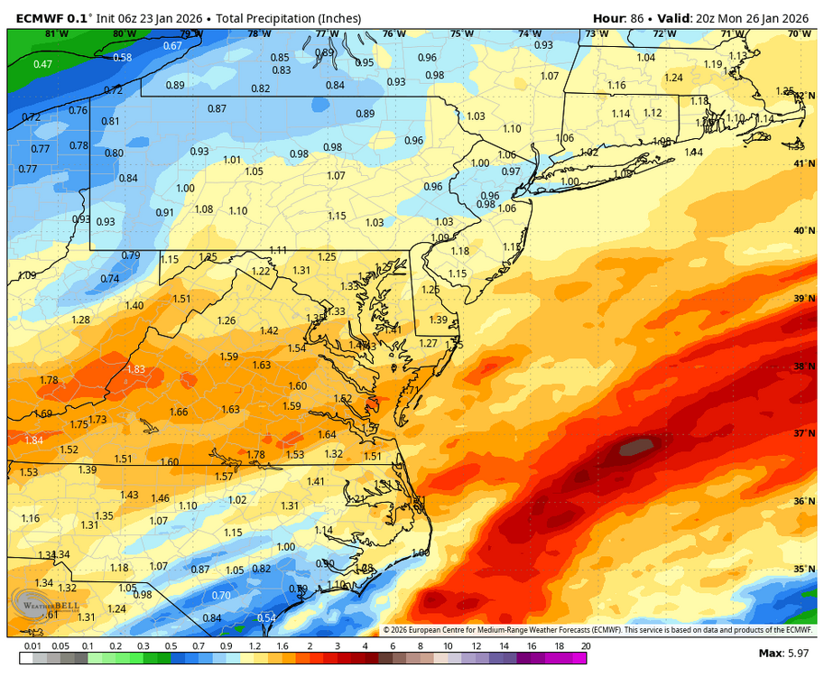
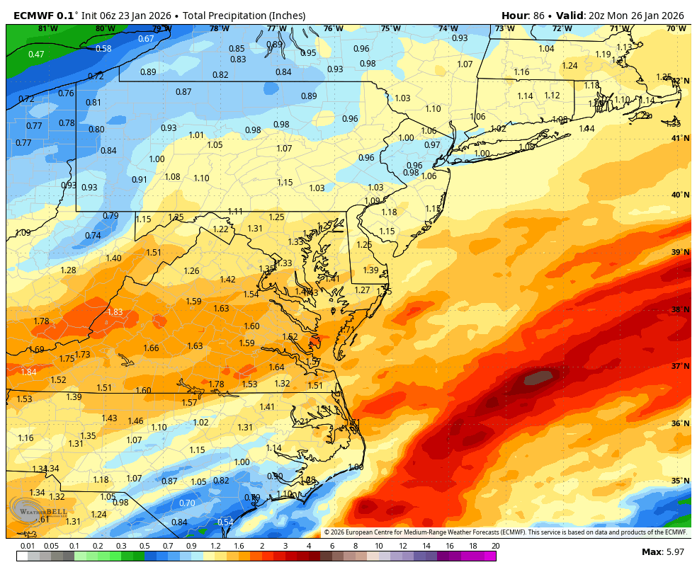
WB 12Z EURO total precip is making PA folks unhappy compared to 6Z.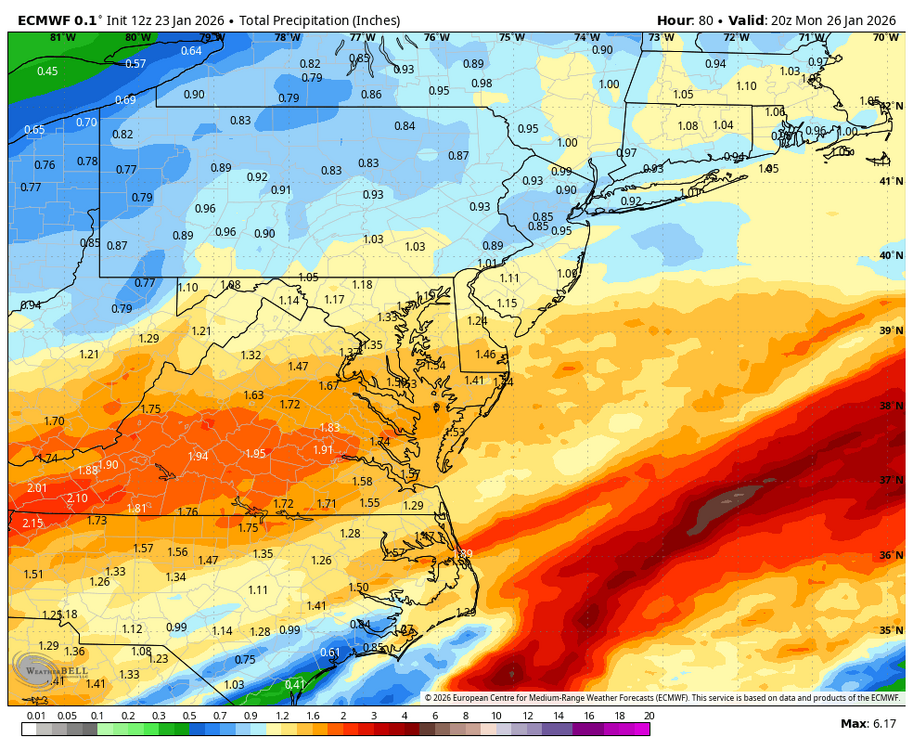
-
I’d like to trade in my sleet for what’s behind door #1.
-
 There have been three this year locally. Where do you get these stats from? What exactly do you consider locally?
 -

Jan 24-26 Weekend Snow and Sleetfest Model Thread Part Tres
Eskimo Joe replied to H2O's topic in Mid Atlantic
Canadian kills the inland low off quick and has a better high. Good signs and it's been trending this way for several runs. https://twitter.com/weatherwilly/status/2014739725769191653?s=20 -

Jan 24-26 Weekend Snow and Sleetfest Model Thread Part Tres
ErinInTheSky replied to H2O's topic in Mid Atlantic
Looking like a good Euro run. -
New York City - 6Boston - 12Philadelphia - 6Washington DC - 3Hartford - 9Albany - 11
-
 Phoenix's expanded UHI is clearly skewing their numbers towards more record warm months. Flagstaff is currently not close to their warmest Jan on record, which was 2003.
 -

Jan 24-26 Weekend Snow and Sleetfest Model Thread Part Tres
DDweatherman replied to H2O's topic in Mid Atlantic
Yep, and it is a bit colder. I appreciated 12z for what we’re looking for here. -

January 25-26 Winter Storm Potential
Hurricane Agnes replied to Ralph Wiggum's topic in Philadelphia Region
The AI one doesn't have that option (unless it's just a Pivotal Weather thing). The regular EC is still running. -

Possible Record Breaking Cold + Snow Sunday 1/25 - Tuesday 1/27
SACRUS replied to TriPol's topic in New York City Metro
-

Pittsburgh/Western PA WINTER ‘25/‘26
Ahoff replied to Burghblizz's topic in Upstate New York/Pennsylvania
Well, just that the surface temp wouldn’t be as cold before the storm and it would be easier to push the warm air in. Just wondering if this could be a concern. -

Pittsburgh/Western PA WINTER ‘25/‘26
colonel717 replied to Burghblizz's topic in Upstate New York/Pennsylvania
AIEuro. Seems we are losing qpf 1/10th at a time but increasing ratios
-

January 25-26 Winter Storm Potential
zenmsav6810 replied to Ralph Wiggum's topic in Philadelphia Region
Perhaps its a more ..."efficient" transfer of the primary to the costal low. That seems to be driving the earlier/faster evolution/colder/more southern solutions -
This would be classic. Sent from my SM-G998U using Tapatalk
.thumb.jpg.84a530b2d090e3329f9e7b06f0c143e0.jpg)
-

“Cory’s in LA! Let’s MECS!” Jan. 24-26 Disco
Cyclone-68 replied to TheSnowman's topic in New England
30 mph winds? Unexpected. Does anyone think the NWS pulls the Blizzard lever? -
Jan 24-26 Weekend Snow and Sleetfest Model Thread Part Tres
DDweatherman replied to H2O's topic in Mid Atlantic
Not a met but fortunately that high of a nose 750-800mb can allow refreezing of droplets in time for sleet to be the ptype. Lower noses around 900mb don’t allow that. -
Possible Record Breaking Cold + Snow Sunday 1/25 - Tuesday 1/27
SACRUS replied to TriPol's topic in New York City Metro
-

Jan 24-26 Weekend Snow and Sleetfest Model Thread Part Tres
Terpeast replied to H2O's topic in Mid Atlantic
That warm layer on your sounding is 5-10kft. Far above 3,000 but plenty of room to refreeze into sleet -

January 24-26: Miracle or Mirage JV/Banter Thread!
H2O replied to SnowenOutThere's topic in Mid Atlantic
Done. I can finally do my Ric Flair impersonation with flabby moobs and leathery skin. And instead of WOOOOO I'll be saying OWWWWWWW My back! -
.thumb.jpg.6a4895b2a43f87359e4e7d04a6fa0d14.jpg)
Central PA Winter 25/26 Discussion and Obs
Yardstickgozinya replied to MAG5035's topic in Upstate New York/Pennsylvania
@Mount Joy Snowman.Maybe you didn't realize the proximity fused thing was my light, harted way of me asking you a question. What's your plans with my elevation or were you just more or less just curious ? -

Jan 24-26 Weekend Snow and Sleetfest Model Thread Part Tres
baltosquid replied to H2O's topic in Mid Atlantic
I can already tell "I'd rather be in Chicago" is gonna become part of the forum vocabulary. But anyway, that trend makes me feel good. Cannot hurt to have the Euro AI trending our way close to game time. -
12PM GSP UPDATE:
-
Need to see the Kuchera map
-

Jan 24-26 Weekend Snow and Sleetfest Model Thread Part Tres
balltermen replied to H2O's topic in Mid Atlantic
Euro is marginally colder, but within the moe for noise. I'd love to see Pivotal soundings for 16-17z Sunday. @yoda? -

Jan 24-26 Weekend Snow and Sleetfest Model Thread Part Tres
psuhoffman replied to H2O's topic in Mid Atlantic
Euro was kind of the model the most "in the middle" so it makes sense it would change the least as we get convergence among the others...


.jpg.bb976313fc8a528d295711781b425446.jpg)


