All Activity
- Past hour
-
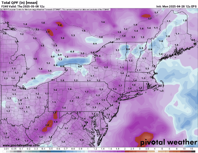
eps and geps trends
-
We do not need the 7" that the euro has. 3" in that time frame is plenty
-
My usual end of month appearance to remind contest entrants (main forum) of approaching deadline for MAY forecasts. On subject of those power outages, I noted that strong winds were blowing in one region of southern Spain and light winds prevailed elsewhere, at time of problems, and during very warm and sunny conditions generally -- could be an imbalance in wind energy contributions to grid causing oscillations.
-
go big or go home. hopefully this wins!
.thumb.png.8546c9cd4057bb97e638e7162f1638cc.png)
- Today
-
loving this dry windy weather..
-
Now the Euro extends the rain through Wednesday. What a difference from a few days ago when it appeared it was gonna rain on Friday and clear out for the weekend. I'm glad to see these changes though ... we need the rain.
-
The qp projections for next week will change at least 12 times in the next 6 days. What seems to be the sweet spot at this time will probably change during the next 48 hrs. Lets don't repeat the normal winter mistakes. The huge potential shift is that in conflict with usual patterns, low pressure surface and aloft will dominate instead of high pressure.
-
ughhh what a HORRIFIC pattern. If that verifies I'm giving myself swirlies in dirty toilet water and get myself dizzy enough to where I become unconscious until June 1
-
Right, I mix it up with the event that hit the Suncook Valley the year before. Where we lived at the time, the 2006 event was a close second to the 2008 ice storm in terms of impact. Before WFH, couldn't commute to work without risking water crossings and road washouts along the route or drive two hours to find a clear path.
-
Latest from WPC has shifted max totals northward (vs. 12Z issuance) from VA Piedmont northward into PA, southern tier of NY and into NJ. This is through 00Z, Thurs. 5/8. Will all depend on placement of upper low and speed at which it exits. Needless to say I would be thrilled with half these totals. Possible southeast fetch lifted into the higher terrain of PA, NJ, NYS could deliver heavy totals but still subject to how upper low evolves.
-

E PA/NJ/DE Spring 2025 Obs/Discussion
RedSky replied to PhiEaglesfan712's topic in Philadelphia Region
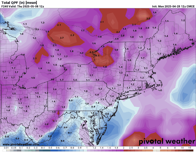
CMC also wants to rain buckets Two against one -
Imagine if we had that look in August or September
-
Hit 71 earlier, now 61..but soooo much nicer than yesterday with barely any wind. Yesterday felt chilly here
-
Made it to 70 ..
-

E PA/NJ/DE Spring 2025 Obs/Discussion
Mikeymac5306 replied to PhiEaglesfan712's topic in Philadelphia Region
Euro wants to rain for days and GFS says Nope. -
Yeah I could see 1-2" out east with 4" and lollis to 5 Tolland west. soaker!
-
Just showing what the models have. We know every time a model shows rain you will disagree, but overall the data points to a wet period. Maybe it’ll revert back to your Stein fetish.
-
Scott, this picture came up on my Facebook "remember" feed. 10 years ago this week. I remember that this picture made me happy. How time flies! Gene
-
Might be one of those deals where BDR to river west are soaked for 24+hrs while it steins east of there before the whole thing migrates east.
-
I'd be willing to sacrifice some days now, for the UKMET to verify ... so that the word stein is never again floated this summer and/or can be set to ignore
-
EPS, GEPS, and Ukie a total disaster Sunday through Wednesday. Lock it in
-
2006
-
through hr 360 but thats a wet EPS run

-
starting to.. but give it a few more runs.. we might have a very wet period coming up
-
A few posters sure are


.thumb.png.e1f898d009b2415a204433df288e6f2a.png)
.png.5859377dfd9e14b06941b69b85a6edb5.png)


