All Activity
- Past hour
-

January 2026 regional war/obs/disco thread
CT Rain replied to Baroclinic Zone's topic in New England
Pretty good trends overnight IMO. Seems like potential for a decent event Sunday/Monday. Don't think the upper end is too high here but could be a nice moderate kinda event? -
That would create so much infrastructure issues well into the following week. I am sure that tems are well below zero over that snowpack as well
-
You thinking WNC sees a little bit of everything? Or chance it stays all snow?
-

Central PA Winter 25/26 Discussion and Obs
Voyager replied to MAG5035's topic in Upstate New York/Pennsylvania
This is from Mount Holly, but relates to our forum as well. As of now, a 40% chance of at least moderate impacts for many in our area.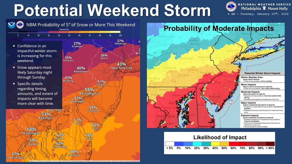
-

January 2026 regional war/obs/disco thread
Damage In Tolland replied to Baroclinic Zone's topic in New England
Looks like 1/4 inch maybe 1/2 from a squall last night -

January 24-25: Miracle or Mirage
SomeguyfromTakomaPark replied to stormtracker's topic in Mid Atlantic
If it can turn the corner the way it’s showing on 6Z euro this could be a 1 to 2 foot type deal for our subforum. Then we can talk about wind too as the coastal deepens. -
Stop the count! Hopefully the North trend stops today. I take comfort in the general bias of models to overdo phasing and make systems more progressive lately. Not sure if that rule of thumb will hold with the pattern change
-
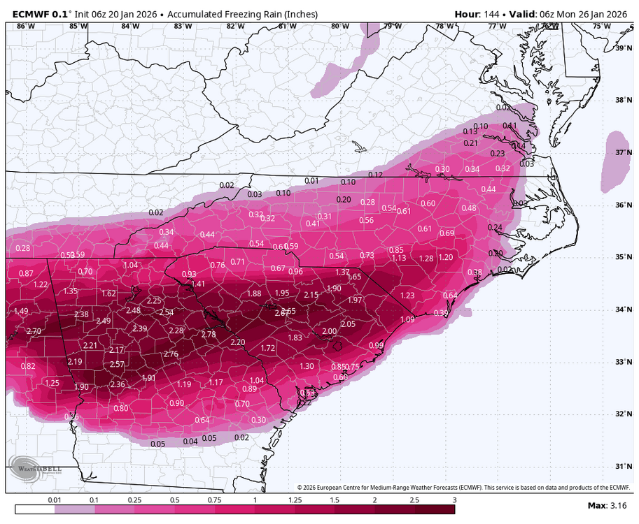
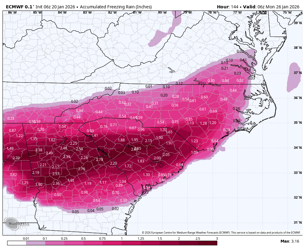
NWS in south central TX is hinting at anomalous moisture over our region at the same time that very cold weather is in our area. I may NOT be safe here at all. Anyone in ice accretion regions with this storm please be extremely careful. This storm means serious bisnass.
-

-

Winter 2025-26 Medium/Long Range Discussion
Baum replied to michsnowfreak's topic in Lakes/Ohio Valley
The Thanksgiving event and subsequent early season arctic outbreak and clipper train put last season to bed early. -
At 144hrs, the slp is sitting over Nags Head with the 50/50 feeding in cold air and the midwest trough pulling in the Gulf moisture while the slp is sorta stuck. Oh boy!
-
These model runs are actually scary:
-
Hey Will. What's the start time? Looks like it's pushed back a little?
-
I think mainly a factor of speed. End result might have been more robust than 0z in totals. Looks awesome up at h5
-
Nothing like a warm nose
-
I was about to mention this because the NAM and RRFS have it as well, almost like an appetizer of sorts. Looks to be on the Euro as well but it's well S of those two:
-
Absolutely insane 6z Euro
-
What an awesome batch of overnight runs. To make things even better, I get to be on a panel at IMD today that moderate by Dr. Louis Uccellini.
-
I would pay to see extra frames of that 6z euro fun. Woulda been a HECS for a good bit of this sub given that h5 at the end and what was already OTG thru 144
-
This is starting to get interesting
-
Yes but about a tenth less in precip compared to 0z at the end of the run. Probably just noise
-
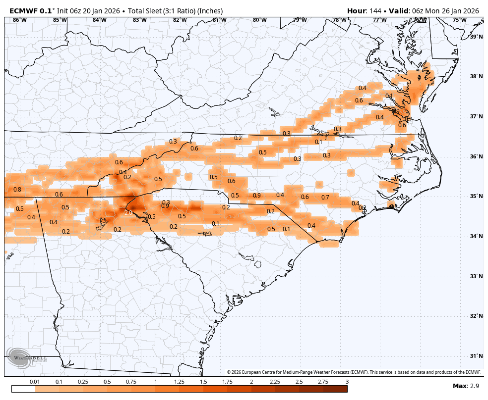
6z Euro with another huge hit. This is starting to get a little worrisome honestly. We really don't need 12"+ of snow and ice on top of that, then temps close to zero. People need to get prepared, lots of power outages are going to occur.
-
And look where the main trough is! It's going to be snowing for a while after that and ratios will be 2/10/10-like potentially.
(11).thumb.png.779115429f9b9c0ce08b171bc4ece3dc.png)
-
The phase looks like the current favorite with the ensembles leaning that way. The Ai jumping on board at 6z and OP having it back to back runs. .
-
January 24-25: Miracle or Mirage
SomeguyfromTakomaPark replied to stormtracker's topic in Mid Atlantic
The low is basically going just east of north last 2 panels of 6Z euro, LFG!!!!


(11).png.9ec3dc39abc779b08425afaa1a20d3dc.png)

