All Activity
- Past hour
-
Well, he manages to claim victory if winter in the east is cold/snowy regardless of how his postulation works out.
-
OMG, you didn't go there.
-

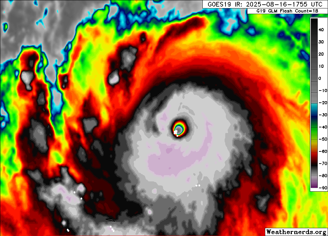
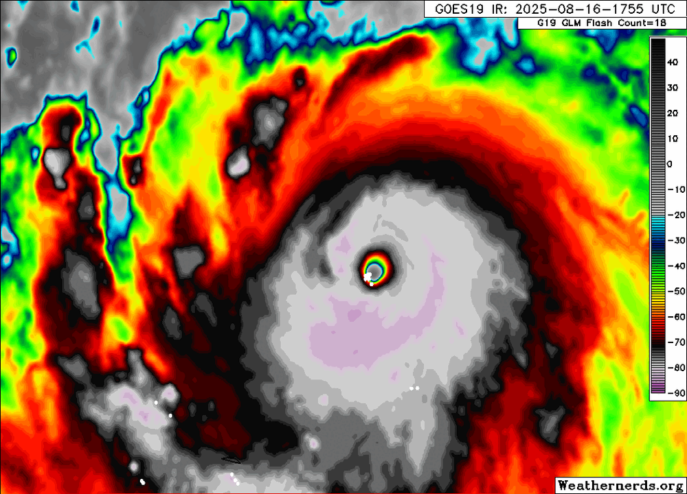
Hurricane Erin: 160 MPH - 915mb - W @ 16
Floydbuster replied to BarryStantonGBP's topic in Tropical Headquarters
Recon should be in there in the next hour. -
Shwrs/stms this morning with temps only in the low-mid 60's this aftrn. Cool day.
-
We just cant know the character of winter until the rate of change of snow cover advance over Eurasia is determined during the month of October.

-
I was gonna say, looks decent on radar there.
-
I wonder about that. Are there verification graphs that compare the two? My prejudiced and unscientific observation makes me think that Skynet is very good out past a week or so.
-

Occasional Thoughts on Climate Change
donsutherland1 replied to donsutherland1's topic in Climate Change
Three things: 1. The focus of my post was Phoenix's monsoon season where recent years have seen disappointing monsoon season outcomes. It was not intended to focus on all of Arizona's monsoon season. 2. The expected impacts of climate change for the Phoenix area were fewer rainfalls, lower monsoon season rainfall and a warming monsoon season. All three are present in Phoenix. 3. The Phoenix area, precisely because it has warmed faster than much of Arizona, could be a barometer of what lies ahead in coming decades as the climate continues to warm elsewhere in Arizona. Aridification won't have a uniform impact in Arizona. Indeed, a prior aridification regime might well have led to the demise of the Hohokam people who resided in the vicinity of where Phoenix is today. -
 Erin is not a fish storm, it's a whale storm.
 -
Absolutely poured here, still moderate. Nothing like a quick .40” to water the yard.
-
I’m at .2 since July 10. Everything is dying fast. Had my roof redone 2 weeks ago and would love rain to help wash any remnants out of the gutters.
-
 Follow NWS/WPC/NHC. I'll monitor for my own interest on whether the more benign GEFS prevails over the more vigorous EPS in our NYC subforum. 12z/16 EPS nw of envelope of remaining global solutions for ERIN. Glad I'm not fishing Atlantic waters Monday-Friday. EPS is as yet the most intriguing for 1-2" 12 hour general rainfall sometime between 8/19-21 for NJ/CT/NYS/PA, in part due to nw flow UL short wave with associated RRQ UL jet in the Maritimes and some relatively shallow low level ese moisture inflow related to the position of the H near Nova Scotia and the L near Lake Erie, connecting a bit with ERIN? EPS PW near 1.5 and increased over the past 24 hrs of EPS cycles for 12z Wed. Lots of fairly deep vorticity NYS into the mid Atlantic states along the boundary next week into Thu AM. 12z/16 EPS gusts much more significant our Atlantic waters vs more seaward GEFS and CMCE. Continues my attention on ultimate results for Tue-Wed-Thu AM next week. WPC at 1841z has added marginal risk for excessive D4 and 5. This line added at 2013z.
 -
Radar has just been depressing this past month. I'm at 0.51" the last 30 days and the grass has gone fast Sent from my SM-G970U1 using Tapatalk

-
I picked up 4” on 10/29/2011 and 4 more inches total the rest of the winter.
-
Bout time for a Fall thread. It sure looks like the summer time pattern is starting to break down a bit early compared to recent years. Cold fronts could be getting further south than recent years if modeling is to be believed. And they are lined up one after another. I certainly don't think we have seen the last of the summer heat, but the sustained heat may well be over by Labor Day - ie weeks on end of high temps and humidity.
-
 Pretty strong sea breeze all day today so high just reached 82°. Yesterday's high was 88° so heat wave here was 3 days.
 -

Hurricane Erin: 160 MPH - 915mb - W @ 16
USCG RS replied to BarryStantonGBP's topic in Tropical Headquarters
What you linked is a great write up. -
96/77/114. It’s disgusting outside.
-
 Boom 90 Day 7 of longest 2025 heatwave rolls on
 -
Nice isolated shower here. Couple of rumbles.
-

Hurricane Erin: 160 MPH - 915mb - W @ 16
wthrmn654 replied to BarryStantonGBP's topic in Tropical Headquarters
-
Pretty sultry out there with dews pushing 80. Looks like today/tonight's action should just miss northeast. Matches up nicely with yesterday's miss west.
-
Hurricane Erin: 160 MPH - 915mb - W @ 16
wthrmn654 replied to BarryStantonGBP's topic in Tropical Headquarters
The eye is getting smaller atleast looking at a loop of it just now -

Hurricane Erin: 160 MPH - 915mb - W @ 16
Windspeed replied to BarryStantonGBP's topic in Tropical Headquarters
RE: US impacts, despite the westward adjustments, they overall will not change. The 500 dm heights of the WATL ridge may be slightly underdone versus modeling, and Erin may also be pumping the SW periphery at present due to its extreme intensity; however, the mid-latitudinal troughs are still coming with a dome behind them that is on a collision course with Erin by 70°W. Erin will go with the southerly flow as Azores ridging drops SW, hooking it N, then NE and swiftly out into the North Atlantic. Interestingly, Erin's deep transition combined with strong rebuilding of the Bermuda extension of WATL heights late next week may spell trouble for what might be down the pipeline, however. But we'll save that for the main seasonal thread. - Today
-

Hurricane Erin: 160 MPH - 915mb - W @ 16
WxWatcher007 replied to BarryStantonGBP's topic in Tropical Headquarters
Still impacts out there. The Virgin Islands are under a flash flood warning and are getting lashed by rain bands.


.thumb.png.4150b06c63a21f61052e47a612bf1818.png)