All Activity
- Past hour
-
With the snow today its 21 days in a row with snow here at DTW. I am tired
-
I wouldn't mind a 3/14/23 event...
-

February 2026 Medium/ Long Range Discussion: Buckle Up!
mitchnick replied to Weather Will's topic in Mid Atlantic
I saw that yesterday on the Euro site weeklies page and was wondering why no one had mentioned it. I've taken enough shade this winter, so I figured somebody would bring it up. Lol -

2025-2026 ENSO
40/70 Benchmark replied to 40/70 Benchmark's topic in Weather Forecasting and Discussion
Exactly. -

2025-2026 ENSO
TheClimateChanger replied to 40/70 Benchmark's topic in Weather Forecasting and Discussion
-
2025-2026 ENSO
40/70 Benchmark replied to 40/70 Benchmark's topic in Weather Forecasting and Discussion
@so_whats_happeningDo you have the link to those EURO images? -
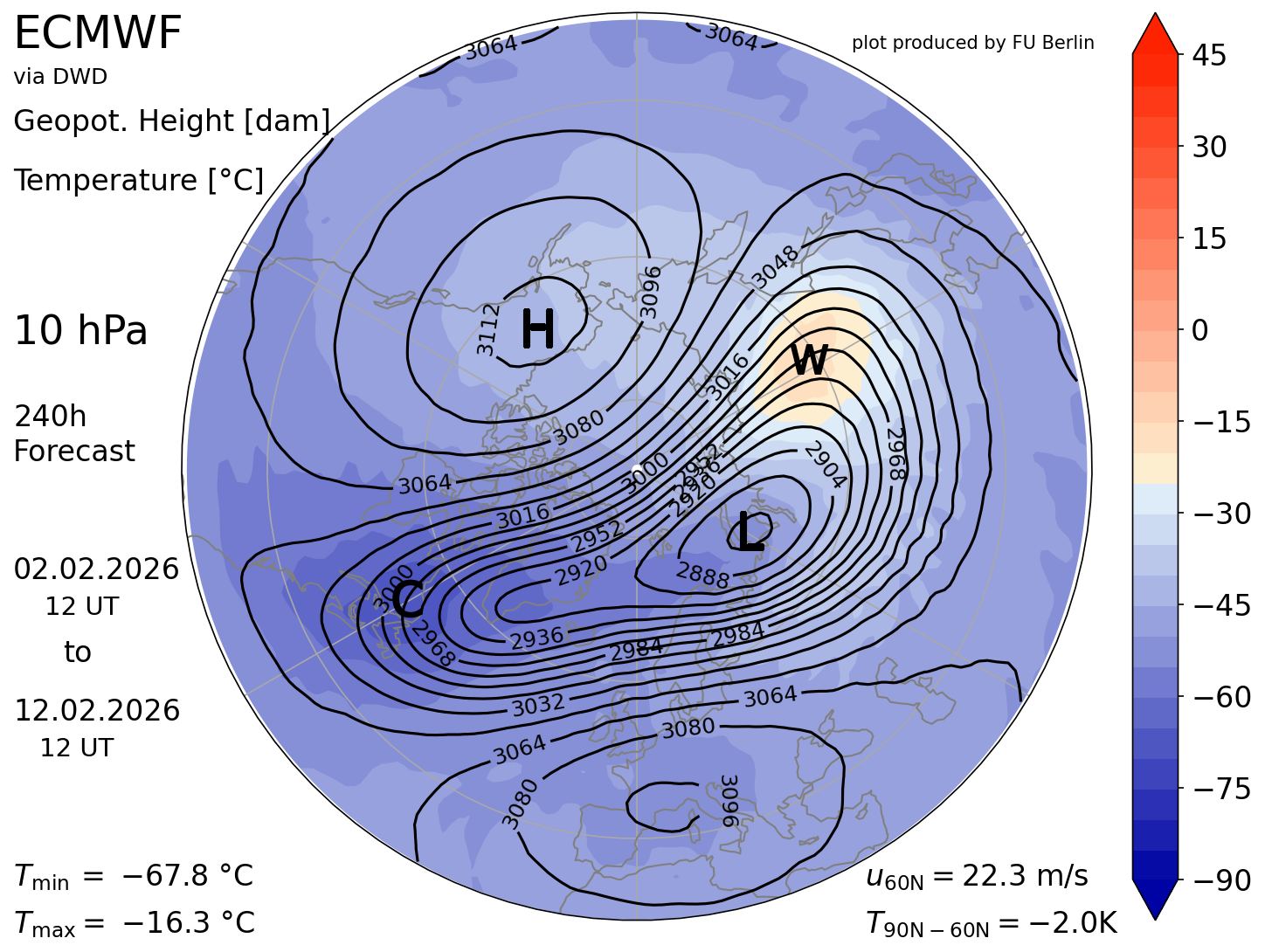
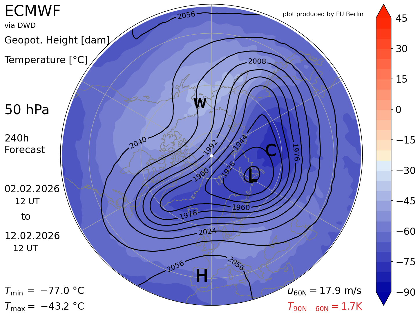
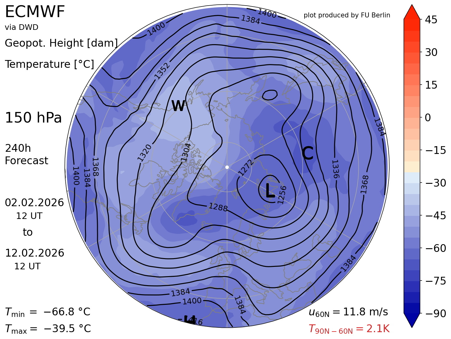
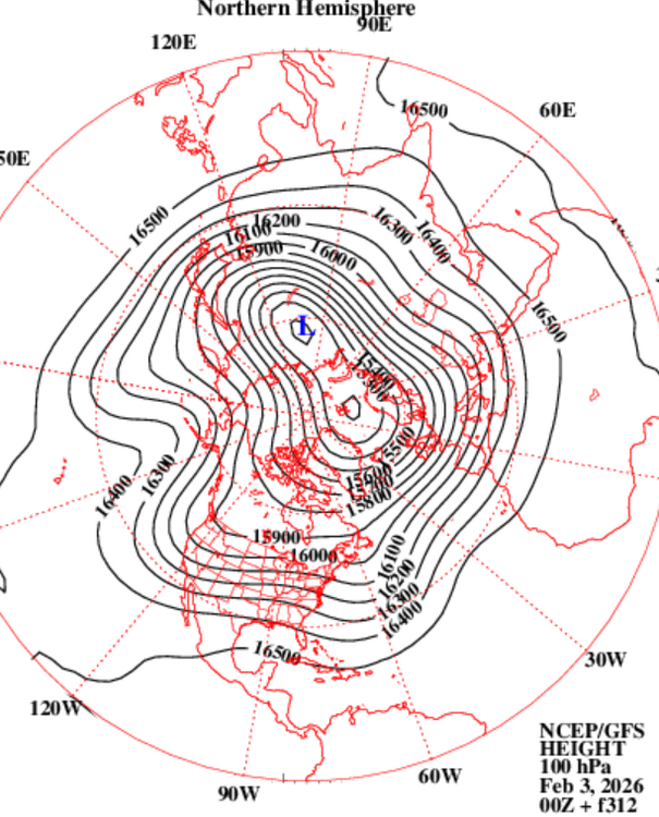
Not trying to burst the meme bubble ... but until that registers in the models as successfully to and thru the 100 mb level, it's unclear (likely not) that there's destined to be a wholesale sigma coupling that eventually/really involves the troposphere. That may yet happen, but support for that is very vague for the time being. 300 hour GFS from recency does shows up heights height response over the Alaska sector, so we may just need to bide time
-

Central PA Winter 25/26 Discussion and Obs
Itstrainingtime replied to MAG5035's topic in Upstate New York/Pennsylvania
I really, really need to put my personal station online. I just haven't since I got my new one. This one is right down the road from me...maybe .2 miles? I'm literally in the radius of this station: https://www.wunderground.com/dashboard/pws/KPAMARIE28?fbclid=IwZXh0bgNhZW0CMTAAAR1aUZn05v6EL1SCu83D6YWAz4KB0xPA7zBHapk7ZxcoZfWMxfMgsX9YEUY_aem_AatgGdtB3HDmy_lQiEQW3p1bDKQzlUbvSccn8VpHsQ_8zcjQ2DxBPNU21ROdUrVrozfMvldDScho9lY6LgyGK0dL It's already 31 in Maytown. -
Ray would like proof
-
With the strat warming event forecasted, this has the feel of a “she’s not gonna let us out” winter. Hopefully March can bring us high end storm opportunities.
-
2025-2026 ENSO
40/70 Benchmark replied to 40/70 Benchmark's topic in Weather Forecasting and Discussion
Guidance was originally insistent that the RNA pattern from the month of December would persist throughout the vast majority of the month of January, with the exception of a brief interval of PNA flex the second week of the month (10th-15th). The above annotation ultimately proved correct in asserting that the forecast return of RNA after mid-month, as suggested by guidance, was in fact erroneous. -
I’m guessing East based solutions just increase the odds of a whiff for everybody?
-
I was just shoveling in a t-shirt and sweating my ass off. I'm calling 45 for the high. Already blasting past the forecast as usual.
-
2025-2026 ENSO
40/70 Benchmark replied to 40/70 Benchmark's topic in Weather Forecasting and Discussion
I'm not arguing with your interpretation of what guidance shows now, rather I'm arguing that it's still adjusting and not there yet. Wouldn't be the first time. -

Is we back? February discussion thread
Damage In Tolland replied to mahk_webstah's topic in New England
What was the total I sent you prior to the 19” big un? I thick was 26 right? So 45” -

Guess The Date Of The Next 12"+ Snowstorm In The OKX Zones
The 4 Seasons replied to bluewave's topic in New York City Metro
yeah, it was def a north/south gradient. Actually a prettty historic event way north with amounts over 18" in far northern MA. It was the 6-7th btw. https://www.jdjweatherconsulting.com/jan-6-7-2024 -
Anybody get the feeling we’re going to get a pasting before winter is over? We seem to be headed for a thaw but if we can get some cold air back on this side of the globe at the end of Feb, I think we might. Been a long time since we’ve had a 5:1.
-
I am ready to move on to severe season being nothing will make up for the screw job on 1/31. Once you get past Valentine's Day it gets a lot harder to get anything worthwhile in most years.
-
Some of us might get pity snow tonight. It may even coat the ground!
-

2025-2026 ENSO
so_whats_happening replied to 40/70 Benchmark's topic in Weather Forecasting and Discussion
Vortex stretching is the term but Im still not seeing a split take hold even with the Euro to 240. It took roughly 30 days to translate to the surface in 2018 (split occurred around the first few days of February) leading to the snowfall events around presidents day and into March. Much different outlook this go around.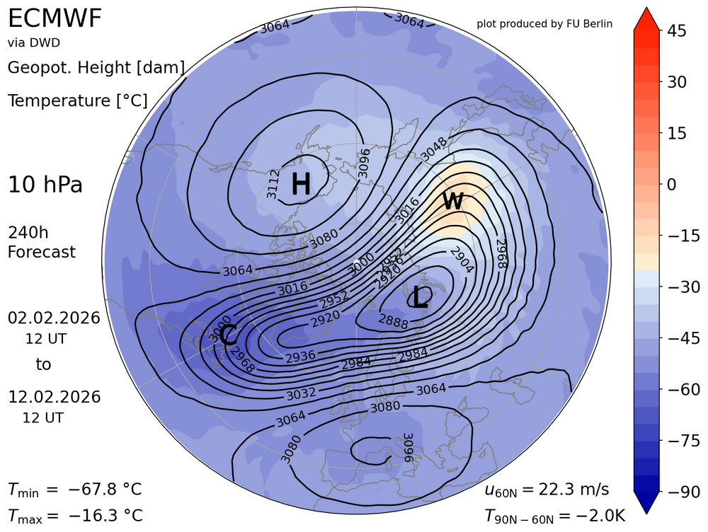


-
Central PA Winter 25/26 Discussion and Obs
Itstrainingtime replied to MAG5035's topic in Upstate New York/Pennsylvania
Yep, that's one degree lower than my forecast which makes total sense. -
We take scraps... WINDEX events can be fun for a bit. Not as good as a big, long duration event of course. Could cover up the dog poop for a bit
-
 One of two decent events that winter in what was otherwise a D winter. January 7th-8th 2024 event was 9.6 inches in Highland Mills. Parts of NW jersey, Places in Orange County northwest of me, and Dutchess county were in the 12-14 range from that event.
 -
do you have a season to date snowfall
-
As we get nearer, the long-range appears to be adjusting a little colder in the modeling, as it has most of the winter. The AI models seem to be leading the way. We'll see where we are in about a week... maybe we can stay on the cold side of the boundary. Total wild card with the PNA ridge breaking down. Historically that would signal springlike weather but the tenor of this winter with the neg NAO and Atlantic pattern could mitigate that. Fingers crossed.


.thumb.png.4150b06c63a21f61052e47a612bf1818.png)