All Activity
- Past hour
-

“Cory’s in LA! Let’s MECS!” Jan. 24-26 Disco
Sey-Mour Snow replied to TheSnowman's topic in New England
Nam'd -
 overall Nam looks way better.
 -

January 25-26 Winter Storm Potential
The Iceman replied to Ralph Wiggum's topic in Philadelphia Region
It also beats back the sleet line. 18z it's pushing into the burbs, 21z its beaten back below freezing. I think it's showing it will be rate dependent there whether you stay snow or not. -
Nam looks better down here....definitely pancaking the precip more, squeezing out a bunch too. Mixing doesnt make it to the CT coast this time
-
Tbh I think roll with the better synoptics and see how it looks at 18z. If it keeps trending like that I feel like at some point the 850s and 700s will respond and we’ll get a better mix line outcome. It may not be a linear process to translate incremental synoptic changes to surface result.
-

January 24-26: Miracle or Mirage Thread 2
NorthArlington101 replied to mappy's topic in Mid Atlantic
FV3 is sexy and I can tell it's at least trying to filter out pure freezing rain. Dunno how it treats sleet. I'll pretend this was the NAM. -

Possible Record Breaking Cold + Snow Sunday 1/25 - Tuesday 1/27
NJwx85 replied to TriPol's topic in New York City Metro
Warmest panel is 03z. Sleet briefly into NYC, then dry slot. -

Possible Record Breaking Cold + Snow Sunday 1/25 - Tuesday 1/27
SACRUS replied to TriPol's topic in New York City Metro
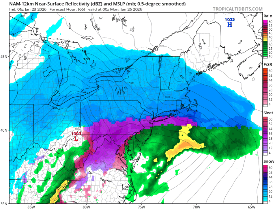
1/23 12z NAM total QPF Total snow / sleet -

January 2026 regional war/obs/disco thread
WxWatcher007 replied to Baroclinic Zone's topic in New England
I know. He’s ridiculous. -
It’s being a little generous with the dgz there. -10C is out of the max dendritic zone.
-

January 24-26: Miracle or Mirage JV/Banter Thread!
LP08 replied to SnowenOutThere's topic in Mid Atlantic
Just look at the FV3. Still snow past 18z. its wrong but fun to look at -

Possible Record Breaking Cold + Snow Sunday 1/25 - Tuesday 1/27
Stormlover74 replied to TriPol's topic in New York City Metro
More mixing.thumb.png.b585f3c2584263435d455b31d7e843b8.png)
-

Richmond Metro/Hampton Roads Area Discussion
jlewis1111 replied to RIC Airport's topic in Mid Atlantic
Looking like a bust from 12znam. Hope its not sniffing things out first like it usually does -
I believe there’s an issue with the NAM. Someone pointed this out on the other board, but if you look at soundings, it’s showing freezing rain but not depicting that on surface maps.
-

January 24-26: Miracle or Mirage JV/Banter Thread!
WolfStock1 replied to SnowenOutThere's topic in Mid Atlantic
Anyone know why Apple weather is so different than NWS forecasts? I don't use it but my wife does, and here's what hers shows this morning for Leesburg area for Sunday: Umm.. what? 24" of snow? Only 70% max chance of precip? Totally different than legit forecasts. Only thing I can figure is that the app doesn't have the ability to account for wintry mix / sleet, so it just does some kind of "snow equivalent" or something (?). No clue why chance of precip is only 70%.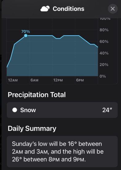
-

“Cory’s in LA! Let’s MECS!” Jan. 24-26 Disco
CCHurricane replied to TheSnowman's topic in New England
How long the primary system holds on over interior mid-Atlantic vs. transfer to the coast will be important for extreme southern New England areas. 12z NAM seems to transfer to coast a bit quicker with primary not making it as nearly as far north. -
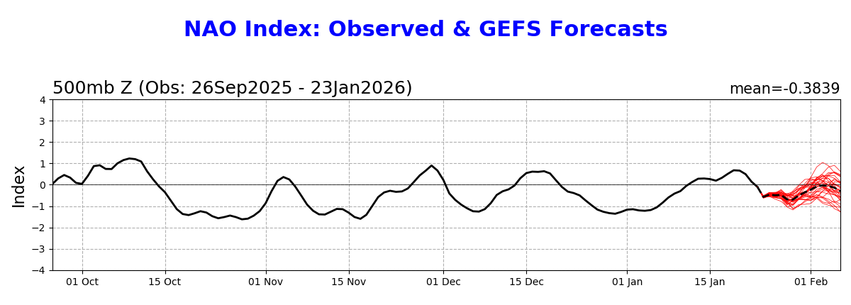
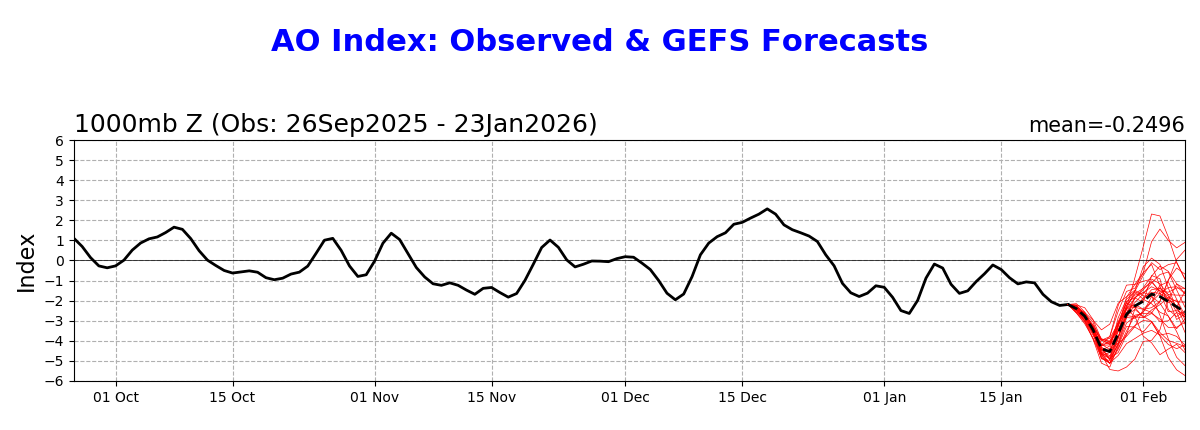
I just grab from the NWS website. Here are the NAO and AO.


-

January 25/26 Jimbo Back Surgery Storm
Upstate Tiger replied to Jimbo!'s topic in Southeastern States
GSP has issued an Ice Storm Warning for my area in Lincoln County (NC Piedmont). -
10-4 and my bad- didn't know if you were referring to blended or non....pure sn, really tough call tbh, but certainly plausible given your location and the dry air at onset
-

Central PA Winter 25/26 Discussion and Obs
GrandmasterB replied to MAG5035's topic in Upstate New York/Pennsylvania
12Z NAM is a big win for our area. Precip arrives faster, absolute wall of moisture, just when we start to flirt with mixing we get a little coastal influence to save us. Great run!! /ninja'd by AccuChris and MJS! -

January 25/26 Jimbo Back Surgery Storm
Brick Tamland replied to Jimbo!'s topic in Southeastern States
That's great news. I hate this storm. -
Wow the 12z NAM just made a jump towards the GFS evolution, keeping things a bit more strung out and transferring to the coast sooner. Still gets the sleet line up to Central Berks county, but no further north. And then things crash back south with more to come early Sunday night. This is probably the NAM doing NAM things, but fun to see and if we see models tick that way at 12z, I might give it credence. Will need quite a few more ticks to see a lot of snow on the backside, the dry slot still kills anything past 03z
-
Definitely starting to get more of that gfs look. Just needs to cool off/shift se a little more.

-

January 24-26: Miracle or Mirage JV/Banter Thread!
stormtracker replied to SnowenOutThere's topic in Mid Atlantic
Altho again, he could very well be valid. I get it. But I would have at least waited till after the entire 12z before I came down. I might join him after that.


.png.ab50ec0d7762d1fc15549f88077b91ca.png)