All Activity
- Today
-

Potential Sever Weather Outbreak 4/27/2026
Torchageddon replied to pen_artist's topic in Lakes/Ohio Valley
ARC137-280400- /O.CON.KLZK.TO.W.0018.000000T0000Z-260428T0400Z/ Stone AR- 1046 PM CDT Mon Apr 27 2026 ...A TORNADO WARNING REMAINS IN EFFECT UNTIL 1100 PM CDT FOR SOUTHEASTERN STONE COUNTY... At 1046 PM CDT, a confirmed large and extremely dangerous tornado was located near Mountain View, moving east at 35 mph. This is a PARTICULARLY DANGEROUS SITUATION. TAKE COVER NOW! Yep, this setup had all the classic signs. Just before I hit the hay, the warnings burgeon and the monsters emerge. -
My dad said he measured an inch of rain in his bucket. Again, .3in of rain at Newport News International Airport.
-

Potential Sever Weather Outbreak 4/27/2026
Jackstraw replied to pen_artist's topic in Lakes/Ohio Valley
I agree. The CAM's were stacking these semi discreet bows like Civil War regiment lines for the last 48hrs whereas the lower res models were playing the synoptic game. Think the CAM's won (maybe not the HRRR, it was just wonky). Some of them looked like late June/July ridge riding cold pool driven bows. Definitely not enough spacing for any sups to bust and run. There's still 80/70's down south and a definite nocturnal threat ongoing down there. Kinda the price we pay in Spring for these setups. We need wide open warm sectors all morning and day with just enough capping to allow more surface based initiation. Sux to waste a stout EML that worked its way this far East. Those will be harder and harder to come by as we move into mid June. -
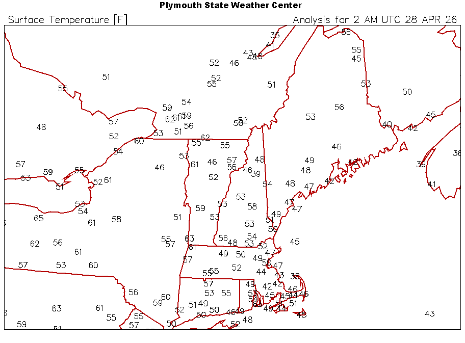
46F in the northern valleys, but the sandy SE MA soil is radiating better so far. Low-40s there.
-
Boomers have been running this country since 1993 - and look where we are. So don't blame it on us.
-

Central PA Spring 2026 Discussion/Obs Thread
canderson replied to Voyager's topic in Upstate New York/Pennsylvania
Hollabaughs sounds less catastrophic- let’s hope that’s true -
Yup...28F to 74F at BML today. Love to see it.
-

Potential Sever Weather Outbreak 4/27/2026
cyclone77 replied to pen_artist's topic in Lakes/Ohio Valley
As expected it was a non-event for the entire DVN cwa. Another bullet dodged. -
Don't mow for a few more weeks and it'll go to seed. Harvest the seeds and put them in a paper bag for a few days then scatter them the day before it rains. If it's already growing on your land successfully it will continue. Buying grass seed is way too expensive anymore.
-
Just for perspective, 2009 was 17 years ago. The climate has not rapidly changed in 17 years. Declaring it has is disingenuous
-

Potential Sever Weather Outbreak 4/27/2026
nwohweather replied to pen_artist's topic in Lakes/Ohio Valley
Just so much crowding with these storms today. I think they get too hyped on ingredients anymore, sure the SRH was great but they gotta have room to breathe -
Potential Sever Weather Outbreak 4/27/2026
Jackstraw replied to pen_artist's topic in Lakes/Ohio Valley
If you want to know where the worst weather is just open you're favorite flight tracker lol
-

E PA/NJ/DE Spring 2026 Obs/Discussion
Birds~69 replied to PhiEaglesfan712's topic in Philadelphia Region
I'm extremely thrilled about this... 57F at 9:30pm -

Potential Sever Weather Outbreak 4/27/2026
sbnwx85 replied to pen_artist's topic in Lakes/Ohio Valley
Round 2 of thundery rain is almost here. -
Good luck. Seed it now before the weeds take over. We have a cool period now with some rain coming this week.
-
Got up to 75F in the valley after a sub-freezing morning. Could do this weather for months.
-
70 today. Gorgeous
- 923 replies
-
- 1
-

-
- april showers bring may..
- rain
- (and 2 more)
-
Tomorrow and Wednesday will see temperatures reach the lower and middle 60s, with tomorrow being the warmer day. However, another shot of rain followed by somewhat cooler temperatures will arrive during the middle of the week. A general 0.50"-1.00" rainfall appears likely for Wednesday into Thursday. May could also open with cooler than normal conditions. The ENSO Region 1+2 anomaly was +1.5°C and the Region 3.4 anomaly was +0.7°C for the week centered around April 22. For the past six weeks, the ENSO Region 1+2 anomaly has averaged +1.47°C and the ENSO Region 3.4 anomaly has averaged +0.27°C. El Niño conditions will likely develop during late spring or early summer. The SOI was -19.11 today. The preliminary Arctic Oscillation (AO) was -0.189 today. Based on sensitivity analysis applied to the latest guidance, there is an implied near 100% probability that New York City will have a warmer than normal April (1991-2020 normal). April will likely finish with a mean temperature near 55.2° (1.5° above normal). Supplemental Information: The projected mean would be 2.2° above the 1981-2010 normal monthly value.
- 923 replies
-
- 1
-
-
- april showers bring may..
- rain
- (and 2 more)
-

Texas 2026 Discussion/Observations
Stx_Thunder replied to Stx_Thunder's topic in Central/Western States
As far as posting activity goes, nothing's changed for the almost 3 years I've been on here now. Really, the only time this state topic gets (real) activity is when snow or a tornado outbreak is forecast in NTX. Which is extremely typical on this wx forum. At least with snow. My goal here (with whatever energy & motivation I can use), is to cover all other wx aspects and parts of this big lone star state I've lived in all my life. Which is also why I do not include OK in these threads. Aside from that, you should already know this is a completely public thread. Anyone, can look up what's being said or discussed in here on major search engines, at least. Google is obviously a no-brainer. The thread view counter, does mean something. -
It has been consistently there since last Thursday model runs.
-
SST Anomaly
- 923 replies
-
- 1
-
-
- april showers bring may..
- rain
- (and 2 more)
-
Records: Highs: EWR: 94 (1990) NYC: 92 (1915) LGA: 89 (1990) JFK: 77 (1949) Lows: EWR: 33 (1933) NYC: 36 (1932) LGA: 38 (1946) JFK: 34 (1967) Historical: 1898: The first Weather Bureau kite was launched in Topeka, Kansas to report daily, early morning, atmospheric observations. By year's end, 16 additional launch sites would be in operation. 1899 - A tornado struck Kirksville, MO, killing 34 persons and destroying 300 buildings. (David Ludlum) 1912: The April 27-28, 1912 outbreak was the climax of a wild, week-long period of severe weather that occurred in Oklahoma. Strong to violent tornadoes struck portions of central and north-central Oklahoma on April 20, 1912. Also, a violent tornado hit Ponca City, OK on April 25, 1912. From the 27 through the 28th, 16 tornadoes rated F2 or greater touched down in the state with 6 of them rated F4. About 40 people were killed, and the storms injured 120 people. 1931 - The temperature at Pahala, located on the main island of Hawaii, soared to 100 degrees to establish a state record. (The Weather Channel) 1931: The temperature at Pahala, located on the main island of Hawaii, soared to 100 degrees to establish a state record. 1942 - A destructive tornado swept across Rogers County and Mayes County in Oklahoma. The tornado struck the town of Pryor killing 52 persons and causing two million dollars damage. (David Ludlum) 1987 - Forty-two cities in the western and south central U.S. reported record high temperatures for the date. The afternoon high of 87 degrees at Olympia WA was an April record, and highs of 92 degrees at Boise ID, 95 degrees at Monroe LA, and 96 degrees at Sacramento CA tied April records. (The National Weather Summary) More than 300 daily temperature records fell by the wayside during a two week long heat wave across thirty-four states in the southern and western U.S. Thirteen cities established records for the month of April. (Sandra and TI Richard Sanders - 1987) 1988 - Mount Washington NH reported seven feet of snow in ten days, pushing their snowfall total for the month past the previous record of 89.3 inches set in 1975. (The National Weather Summary) 1989 - Thunderstorms produced severe weather from the Lower and Middle Mississippi Valley to Virginia and the Carolinas. Hail up to four and a half inches in diameter caused five million dollars damage around Omaha NE. Thunderstorms spawned eleven tornadoes, and there were 160 other reports of large hail and damaging winds. (The National Weather Summary) (Storm Data) 1990 - Thunderstorms produced severe weather in eastern Texas and the Lower Mississippi Valley. Severe thunderstorms spawned thirteen tornadoes in Texas and twelve in Louisiana. A tornado southwest of Coolidge TX injured eight persons and caused more than five million dollars damage. There were also eighty-five reports of large hail and damaging winds, with baseball size hail reported at Mexia TX and Shreveport LA. (The National Weather Summary) (Storm Data) Forty-three cities in the eastern U.S. reported record high temperatures for the date. Records highs included 94 degrees at Charleston WV, 95 degrees at Baltimore MD and96 degrees at Richmond VA. (The National Weather Summary) 2003: For only the 11th time since records began in 1871, hail was observed in Key West Florida. A severe thunderstorm produced hail to 1.75 inches in diameter which easily broke the previous record of a half an inch in diameter which was set on May 10, 1961. 2011 - An estimated 305 tornados between the 27th and 28th sets a record for the largest outbreak ever recorded, including two EF-5s, four EF-4s and 21 EF-3s. Arkansas through Mississippi, Alabama, Georgia, southern Tennessee, Virginia to Pennsylvania and New York were all affected. An estimated 300 died including 210 in Alabama alone. This brought the April total past 600, the most in any month in recorded US weather history.
-
WPC seems to believe days 4, 5, 6 and 7 rainfall all mostly miss to our South. Typical .
-
Texas 2026 Discussion/Observations
Stx_Thunder replied to Stx_Thunder's topic in Central/Western States
DFW convective environment still looks worked over from Saturday night's slow-moving, significant hail & flood producing supercells. Which wasn't even 48 hours ago yet. Mainly cloud lightning so far on current lightning data (despite sfc temps around 90 F at 7 pm). Could definitely still be some lower-end severe hail with such abnormally steep mid-level lapse rates in place (8 - 9), and modest DL shear on obs soundings across the state today. But, those abnormally steep ML lapse rates could definitely contribute to a more significant large hail threat in C/STX with more widespread, moderate DL shear overspreading the state later this week. -
Really underwhelming so far, we'll see if this'll turn into a nocturnal event.


