All Activity
- Past hour
-
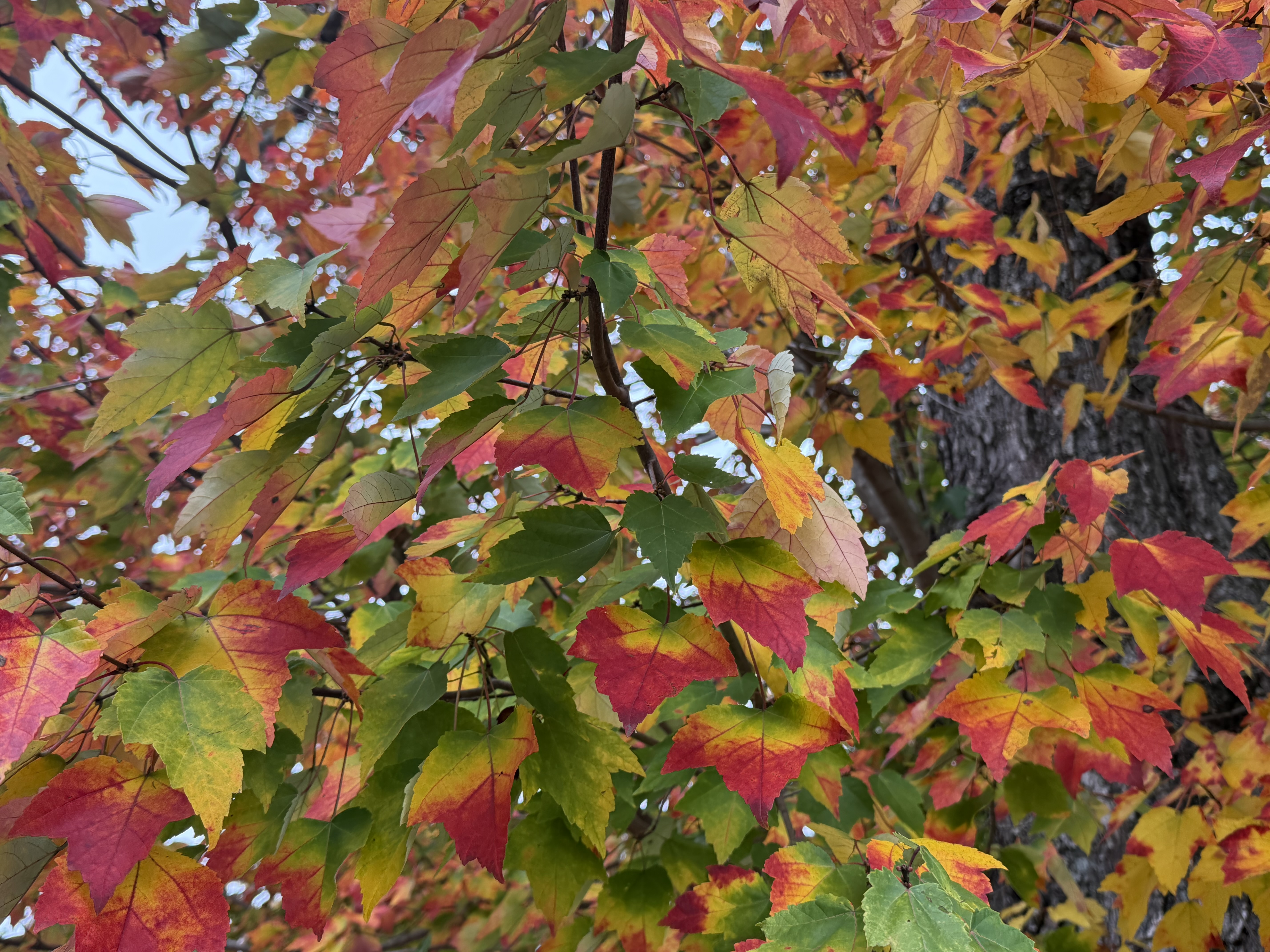
Leaf fall seemed to really start in earnest just the last couple days around me. Definitely at peak color more or less.
-
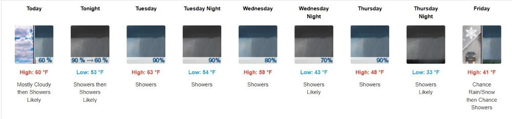
A wet week with a gradual cooldown. In most years winter sets in quick in the north come November. Mother nature has different ideas this year.
-
That sucks. The NAM was like the fun guy that always shows up to the party already drunk and brings weed.
-
Splitting wood with crickets chirping, no shirt , before 10:00 a.m. on November 2nd. Wasn't on my bingo card.
-
Wild flooding continues in AZ https://www.facebook.com/reel/1734696424299188/?referral_source=external_link&surface_type=tab&in_reels_tab_context=TRUE https://www.tiktok.com/t/ZP9yp7Do7uj4L-spOnJ/
-
2026-2027 Record-breaking El Nino
BuffaloWeather replied to Stormchaserchuck1's topic in Weather Forecasting and Discussion
For me and many others that post here, it just takes 1 storm to make a winter. A lot of us just want big dogs, we don’t care about sustained cold and 1-3” storms. Those are boring. There is a chance at a big storm in any winter. -
Shower here produced 0.01” of rainfall, a real drought buster
-
Incredibly rare non-tropical rainfall event in Florida today. Palm Bay has seen 15-20” of rain with 3-5” per hour rainfall continuing. Some areas could see 25” of rain! Flash flood emergency for catastrophic flooding in effect
-

Occasional Thoughts on Climate Change
Typhoon Tip replied to donsutherland1's topic in Climate Change
The first sentence of that is broadly true, "The IPCC, NASA, NOAA, and EPA state that essentially all of the observed rise in atmospheric CO2 since the pre-industrial era originates from fossil-fuel combustion" but is spun and too absolute. In other words, they're indicating the rise in CO₂, fossil-fuel emissions being the largest contributor, not the sole source. Example, NASA describes the long-term increase as primarily driven by burning coal. They are not saying all. That matters... Not sure if that forced interpretation is just a standard method in formulating arguments among the "paper vs paper" ambit - it could cultural. They lie about what the other says, very cleverly... What I also find immediately critical about this abstract is that it does not appear to include - if even aware of - the synergy in the whole system; where natural elements and events, happening in tandem with anthropomorphic contribution/adding of volatile chemistries are where the story becomes critical. There' mathematical model comes of as a sand-box in the middle of much bigger beach of wave actions. Which, they may be 100% correct in that confined consideration, but reality is a holistic result. We know that in the case of CC that is true. Because when mathematically calculating anthropomorphic contribution, and then mathematically calculating the natural order, the differential happens to equal the the last 120 years of climate change to a very close confidence interval. SO, quibble over the math scaling while the world ends ...okay. -
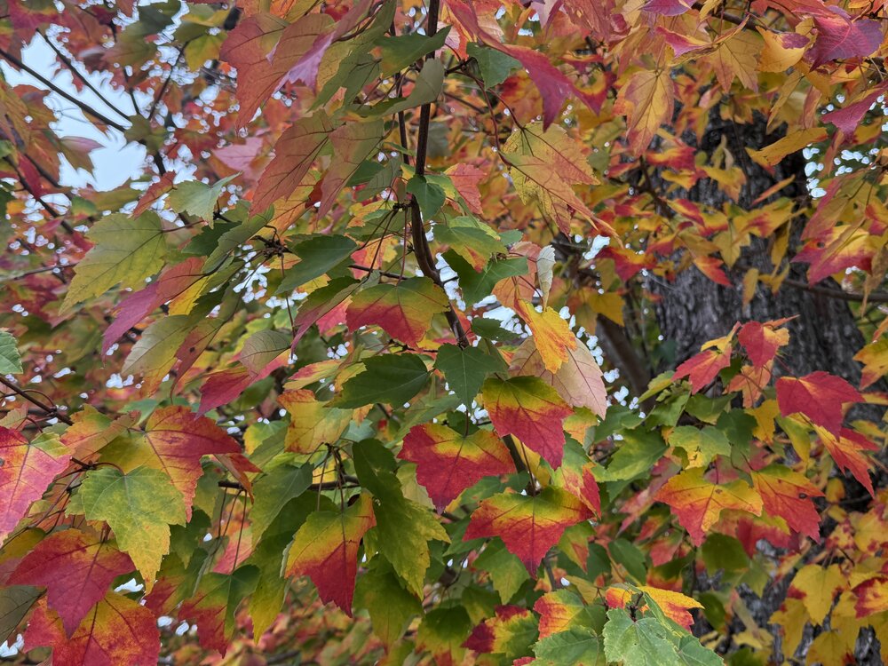
Leaf fall is well behind schedule here looking my past photos. Usually I have piles by this point but our front yard maple is still up and colorful.
-

2026-2027 Record-breaking El Nino
snowman19 replied to Stormchaserchuck1's topic in Weather Forecasting and Discussion
This is only the very beginning of what is certain to be a super Nino induced, record-breaking STJ for the next 4+ months. The ++PMM and strong +QBO are only going to enhance it even more -
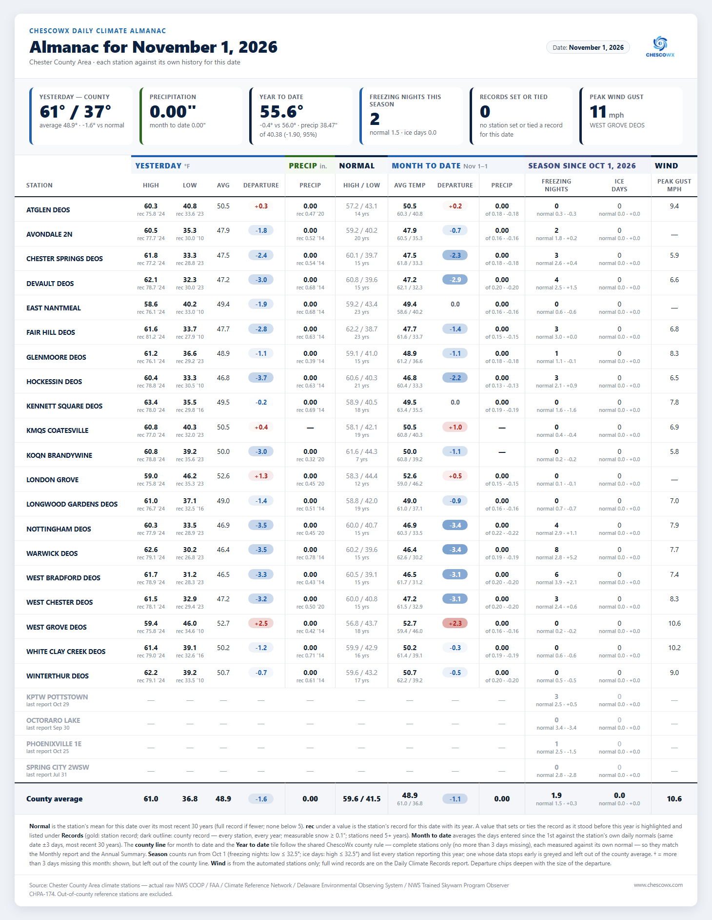
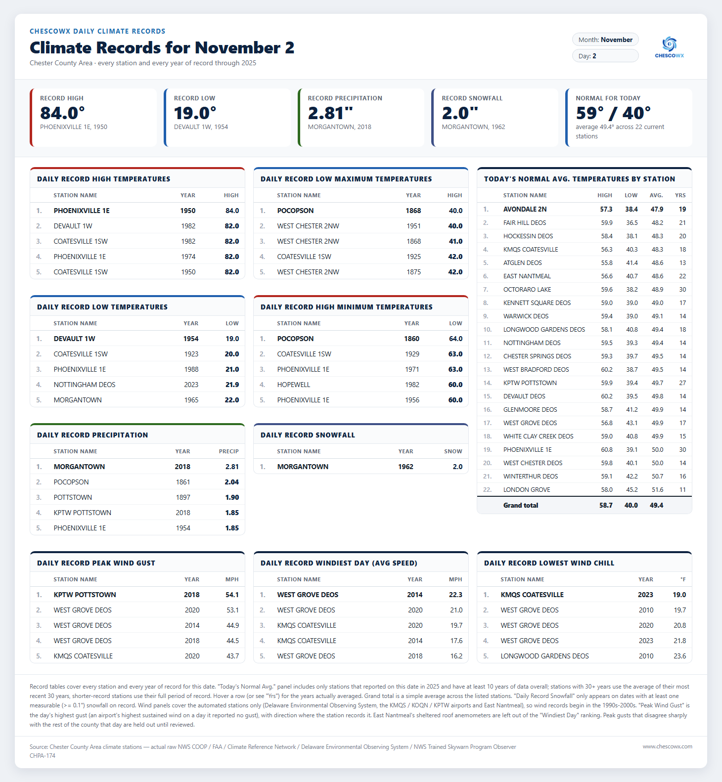
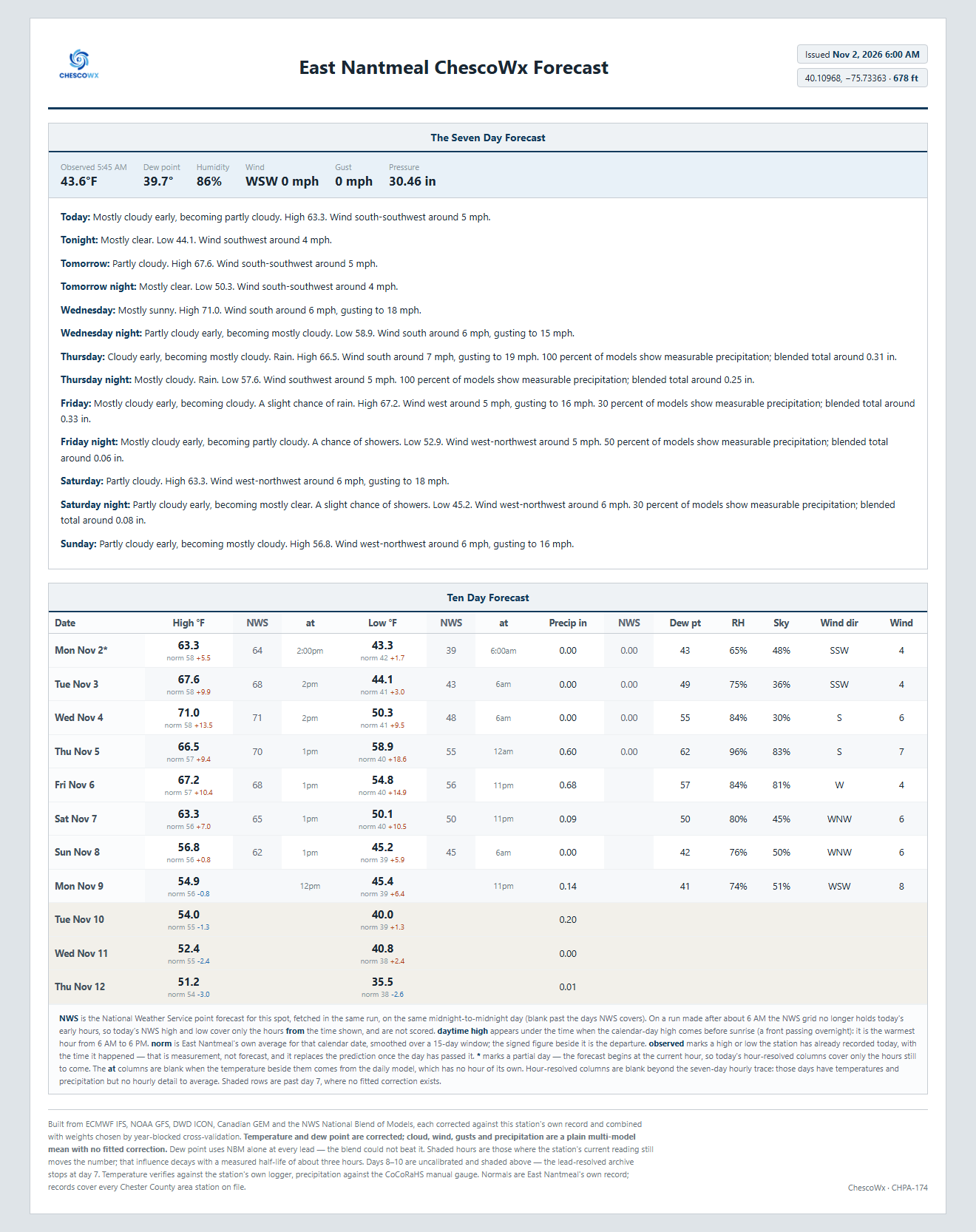
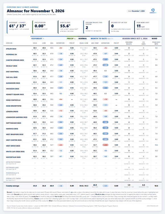
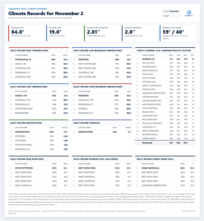
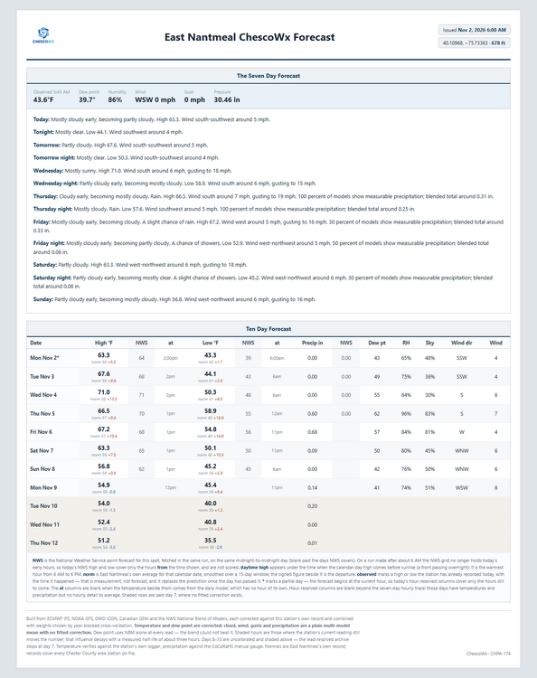
Today we should see highs from low 60's in ridge locations to the mid 60's in valley spots with lows tonight in the upper 30's to mid 40's. Highs will peak on Wednesday with highs in the low 70's which is around 10-12 degrees above normal before we return to near normal over the weekend. We should see a pronounced pattern change during the upcoming weekend with temperatures by Sunday falling to below normal levels for November with temperatures later next week getting no higher than the lower 50's. It has been a while since our last rain but our best chance of rain is Friday with around 0.68" according to the ChescoWx model. Of note 165 years ago today back in 1861 the Chester County Area was at the start of a storm that left as much as 2.04" of rain at Pocopson. This was an unnamed tropical storm which tracked within about 140 miles of the county.
-

E PA/NJ/DE Autumn 2026 Obs/Discussion
ChescoWx replied to PhiEaglesfan712's topic in Philadelphia Region
Today we should see highs from low 60's in ridge locations to the mid 60's in valley spots with lows tonight in the upper 30's to mid 40's. Highs will peak on Wednesday with highs in the low 70's which is around 10-12 degrees above normal before we return to near normal over the weekend. We should see a pronounced pattern change during the upcoming weekend with temperatures by Sunday falling to below normal levels for November with temperatures later next week getting no higher than the lower 50's. It has been a while since our last rain but our best chance of rain is Friday with around 0.68" according to the ChescoWx model. Of note 165 years ago today back in 1861 the Chester County Area was at the start of a storm that left as much as 2.04" of rain at Pocopson. This was an unnamed tropical storm which tracked within about 140 miles of the county.
-
If you always anticipate failure, then success tastes twice as good. I've worked too long in public safety. Everything tastes like ash these days.
-
Eskimo "No Snow" Joe
-
I'm curious what GISS graphical layout looks like in 10 or so days... My hunch is that there'll be a relative min round New England.
-

2026-2027 Record-breaking El Nino
bluewave replied to Stormchaserchuck1's topic in Weather Forecasting and Discussion
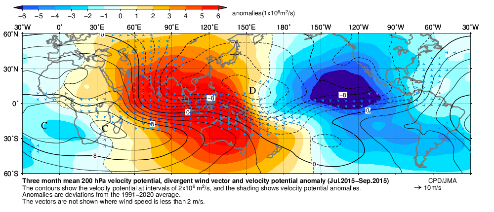
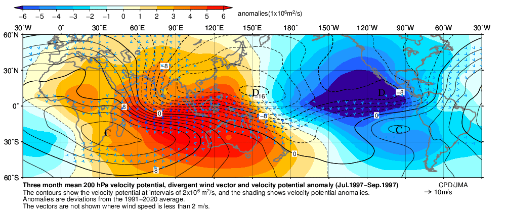
I get it that they are struggling to measure how ENSO is changing as the climate warms. But the extreme nature of the flooding from the Southwest to the Southeast this fall would better be reflected by the higher values. Plus the warmth is greater than we have ever experienced for so early in a super El Niño event. The east based forcing has also been much stronger than we have ever seen so early in an event.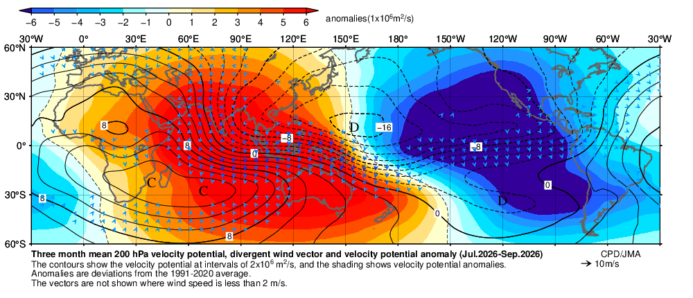
-
so what makes the CanSIPS "not the greatest long range guidance" ??? - if you have anything greater post it here !
-
Tropical Weather Outlook NWS National Hurricane Center Miami FL 700 AM EST Mon Nov 2 2026 Western Atlantic: An area of low pressure is likely to form along a weakening frontal boundary a few hundred miles northeast of the Bahamas in a couple of days. This system could acquire some subtropical characteristics late this week while it drifts over the western Atlantic. The chances of subtropical development should end by the weekend when the system is expected to move eastward or northeastward into unfavorable environmental conditions. * Formation chance through 48 hours...low...near 0 percent. * Formation chance through 7 days...low...20 percent. The too bullish as of late UKMET has had this for several runs fwiw.
-
The last run will be 06 UTC tonight. OMD has said that they have not done studies on the RRFS / REFS sensitivity to CAD wedges (and area that the NAM excels in) and just to put the icing on top. OMD has pulled the freezing rain and sleet accumulation products from the feed because it sucked so bad. https://www.weather.gov/media/notification/pdf_2026/scn26-048_Updated_RRFS_and_REFS_Implementation.aaf.pdf NEW changes as of Oct 15, 2026 Updated to reflect adjustments to post-processing and product availability within RRFS and REFS, primarily replacing a model-generated, microphysics-based instantaneous precipitation type product with a diagnosed thermodynamic-based precipitation type calculation, and also removing accumulations of freezing rain and frozen rain (sleet) as output products. These changes are in response to an over-forecasting of freezing rain and under-forecasting of sleet within RRFS/REFS.
-
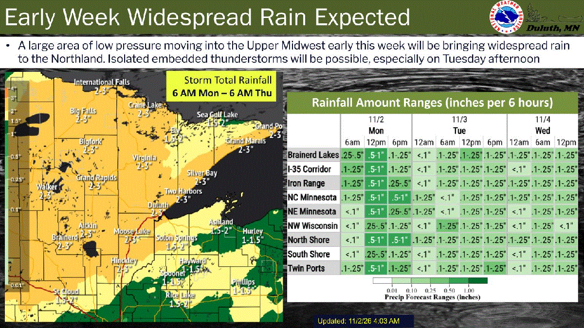
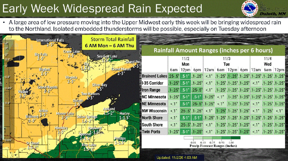
Looks like a quarter inch to 3" of rain
-
Don't disagree here ... But I'd just add, there only needs to be a spark to detonate an entire field of natural gas. Believe me, this year in particular, perhaps above all others, there is an ocean of gas. ...it's proven to be a part of the bounty that CC provides, anyway.. but now this on top. Forget snow or rain ... anything that happens could end up synergistically out of control production. Granted, we have to be cold enough if the discussion is snow-related... yes, there is a non-zero possibility that it is never cold enough, at least down here. I doubt it... but is so. I would never bank on that in alpine setting, either way ... maybe in 10 or 20 years of brick dipshits denialism succeeding in pushing the extinction event to the brink... But at this time, no. Otherwise, we may as well send up palm frowns to Caribou ME already. Short version, the same clipper in 1987, could product 33" these days, the specific physical mechanism is that CC and now this El Nino, pointing it's cosmic-scale hot anus at us... are ceiling the amount of water vapor can physically be in Earth's atmosphere. If cold is sniffable, it could snow that much by accident - whether it's 70 F a week later or not.
- Today
-
CanSIPS = not greatest LR guidance to put it mildly. Taken verbatim not a good look there. Would rather those positive anomalies more northward. Never been a fan of positive anomalies centered near Hudson Bay to get cold air in here especially with this overall warm background state. It does limit cutting of systems into the GL though. Implied split flow there with active northern and southern storm tracks. Lack of cold air would be the main problem. No cross polar flow to seed cold air into Canada. If anything Canada looks to be dominated by milder Pacific Air. This is why I'm not relying on SSW/PV split to deliver much for later Nov. into Dec. SSW/PV vortex splits are dicey on what they produce and where in the best of situations. Raging Nino will likely overcome this upcoming SSW/PV split. CanSIPS aside there is ample evidence from other LR guidance for a December with AN temperatures and precipitation. Snowfall for our area will have to depend of a well tracked and well timed system with whatever cold air becomes available. Keeping my expectations low. We're going to have to get lucky this winter to see above normal snowfall. Having said that one well timed coastal with a good track could get us there. That is the wildcard this coming winter. IMO. In the meantime looking forward to the late week rains for a chance of pace.
-
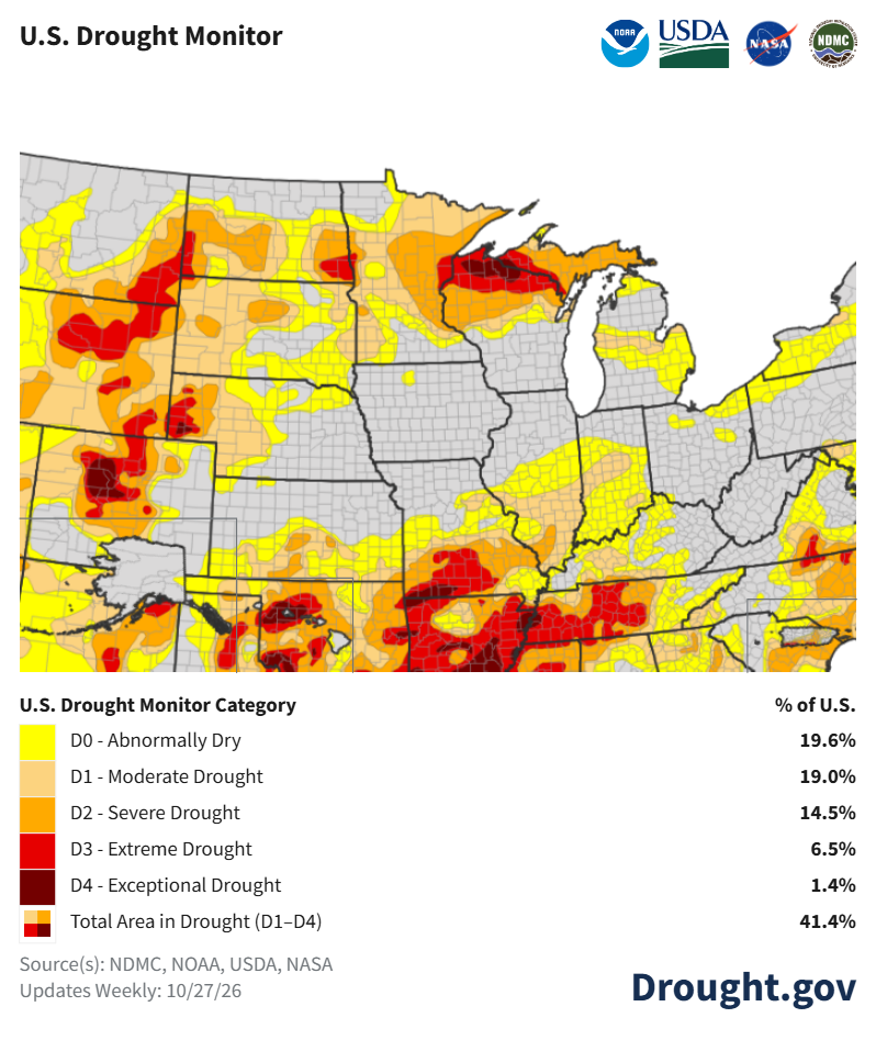
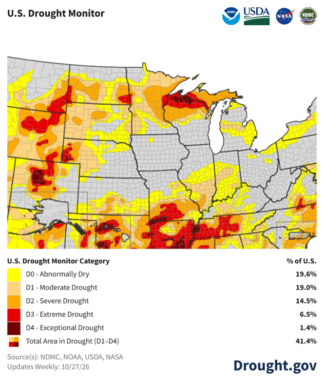
This will be a big help for the drought conditions
-
https://papers.jcohler.com/keeling