All Activity
- Past hour
-
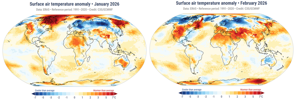
This has been an interesting first three months of 2026. So far ( date provided by Copernicus) : January 2026 was the fifth-warmest January globally. February 2025 was the fifth-warmest January globally. Notables so far were the extreme variations in temperature across N/A and parts of Europe, where negative anomalies significantly offset the state of total planetary system during January. Those of N/A alleviated, being replaced by +anomalies, with lingering negatives of the far E continent. Northern Europe continued with impressive negative anomalies. The graphic below illustrates these idiosyncrasies. ( I corroborated the above with NASA's releases and they conform ) March is not yet available at either Copernicus or NASA's monthly releases. NASA typically releases their finding s around the 10th of each month so we expect those soon. We know already that March 2026 was the warmest March on record across N/A mid latitude ( conterminous US), per more sources than need to really list here. Go take a look. However, again, both in data, as well as "sensibly" experienced, this was not have been as readily observed for the eastern mid latitude continent. Nevertheless, these eastern geographies accumulated +2 to +3 positive anomaly for the month - so ours was likely still negative relative to the whole continent, which can be ratified soon enough. This may or may not be reflected in the total graphics including the Mid Atlantic and eastern Ohio Valley and some parts of the SE. Personally suspect given a-priori awareness of the global circulation modes for the past 7 months and the persistence thereof, .. I suspect we'll see a repeat of relative offsets over eastern N/A and N-W Europe, while the rest of the world observes a ranking somewhere in the 3rd to 6th place. The beat goes on...
-
Coldest on my Davis was 29.1°F this morning. 30.0°F yesterday morning (4/8) I'm a little surprised to be a bit warmer than some fellow LI posters considering I'm usually the coldest this time of year with my proximity to the water
-
Columbia area people: do you have any favorite local walking, hiking, maximizing nature/minimizing people spots? I've been spending a lot of time visiting my elderly dad there, and he walks and drives and does stuff, but most of the time he's indoors. There's not much of a yard and I need some go-to, close by spots to hike or chill outside for an hour or two when it's glorious out! Patapsco is great but a bit far. Over the winter I discovered paths in the immediate neighborhood and walked around some of Wilde Lake and Kittamaqundi. My folks moved to Columbia a long time ago from Balt. Co. but most of what I've done there is just go to their house and out to eat! Thanks for any recs.
-
April 9 1931: Severe dust storms are reported in St. Paul. For Thursday, April 9, 2026 1877 - Oregon Inlet, NC, was widened three quarters of a mile by a nor'easter. (Sandra and TI Richard Sanders - 1987) 1947 - A tornado struck Woodward, OK, during the late evening killing 95 persons and causing six million dollars damage. The tornado, one to two miles in width, and traveling at a speed of 68 mph, killed a total of 167 persons along its 221 mile path from Texas into Kansas, injured 980 others, and caused nearly ten million dollars damage. (David Ludlum) A man looking out his front door was swept by a tornado from his home near Higgins TX and carried two hundred feet over trees. The bodies of two people, thought to be together at Glazier TX, were found three miles apart. (David Ludlum) (The Weather Channel) 1977 - A storm brought 15.5 inches of rain to Jolo, WV, in thirty hours. (The Weather Channel) 1987 - International Falls, MN, reported their sixth straight record high for the date, with a reading of 77 degrees. A cold front ushering sharply colder weather into the north central U.S. produced wind gusts to 60 mph at Glasgow MT. (The National Weather Summary) 1988 - Residents of Sioux City, IA, awoke to find two inches of snow on the ground following a record high temperature of 88 degrees the previous afternoon. (The National Weather Summary) 1989 - Eighteen cities in the southwestern U.S. reported new record high temperatures for the date. The afternoon high of 80 degrees at Eureka CA established a record for the month of April. (The National Weather Summary) 1990 - Thunderstorms developing ahead of a cold front produced severe weather from the Central High Plains to Arkansas and northern Texas. Severe thunderstorms spawned five tornadoes, and there were seventy reports of large hail and damaging winds. A tornado injured four persons at Ardmore OK, and thunderstorms produced wind gusts to 70 mph at Kellyville OK, and hail three inches in diameter at Halmstead KS. (The National Weather Summary) (Storm Data) 2011 - An EF-3 tornado hits Mapleton, IA. Officials estimate more than half the town is damaged or destroyed but none of the 1200 residents were killed. 31 tornadoes were confirmed across Iowa, Kentucky, Tennessee and North Carolina on this day.
-

2026-2027 El Nino
brooklynwx99 replied to Stormchaserchuck1's topic in Weather Forecasting and Discussion
if we go the super route, I actually like 1982-83 quite a bit -

Central PA Spring 2026 Discussion/Obs Thread
Superstorm replied to Voyager's topic in Upstate New York/Pennsylvania
29F last night. Masters is on. Got my new golf clubs yesterday. Temperatures warming. I am loving it. -

Central PA Spring 2026 Discussion/Obs Thread
Mount Joy Snowman replied to Voyager's topic in Upstate New York/Pennsylvania
Yep, Midwest stealing all our rain...... -
Ever since 2023 every time the Niña breaks the dry pattern injects steroids instead of dying. Did something else break in the atmosphere and now it’s raining less?
-
mild and dry times ahead. Take!
-
Rather than painstakingly line-itemizing everything that's taken place ... will defer to https://climate.copernicus.eu/sites/default/files/custom-uploads/GCH-2025/GCH2025-full-report.pdf ... to elucidate notables and various drill-downs. 2025 was the 3rd warmest year in general. Starting the thread for 2026 -->
-
33 for the low in Great Falls
-
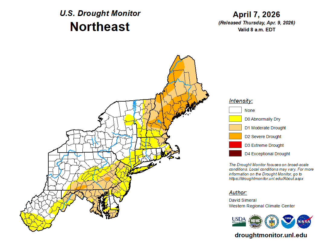
Next week extreme will probably exceed 25% of the state
-
We rage on
-
KFOK 19°
-

Spring 2026 Pattern Discussion Thread
Carvers Gap replied to Carvers Gap's topic in Tennessee Valley
Ditto. My garden has been doing decently well so far, but I too have fought the urge to plant the warm wx stuff. I may risk planting 1-2 in a cold frame next week. This pattern seems pretty stable, but we have both seen warm, spring patterns flips to one frost after another. The drought monitor has drought expanding across much of Tennessee. -
Frosty 26°
-
can't remember the last time chicago was in D6 and D7 outlooks
- Today
-
27 here as well. Time to start that growing season for real.
-
44 .. up from 23 Probably heading for MOS+routine bust ticks. Little or no wind and now late summer solar rad will certainly max out the nape factor. Psycho babble this will put mindsets and posting vibe some distance from this morning's disgruntling bite. I'm not sure it's the last of the freeze chances (season) though, due to further below... But yeah, the models do shows some elevating thickness out there. It's just that the ambient polar boundary is still gradient packed and that's not a good look. Pattern is trying, but it is as though the models in an internal war to prevent seasonal change. That's that tongue-in-cheek vibe in the current modeling cinemas. The problem is ... it wouldn't look that way if we could just at last remove that 90/60 PV. 00z ensembles re-invigorated it, after a couple cycles whence it finally looked - after 7 months of it no less... - like it was going away. Until that succeeds, we'll keep seeing these wild temperature ranges, S-N, at mid latitude continent. We'll also suffer greater than normal BD in the means... I just recall at least 3 Mays since 2019 whence there were flurries at mid day with blown out virga cu passages, and I don't recall those years having this PV plague. Case in point, this next Wednesday. Seems with the above concepts in mind, then combining with base-line climo, there's a pretty good gamble that frontal arm ends up down near DCA with NE drill. Right now, the models are tussling with a boundary, selling a precariously float near Brain or myself latitudes. But 1030 mb and +PP N of that boundary like that? feels like a 10 year old wondering if Dad'll be mad when he gets home from work to find out he was playing with old man's gun
-
Nice stretxch upcoming. Noticed the first tiny leaves on maples in my yard yesterday evening. A bit early maybe?
-
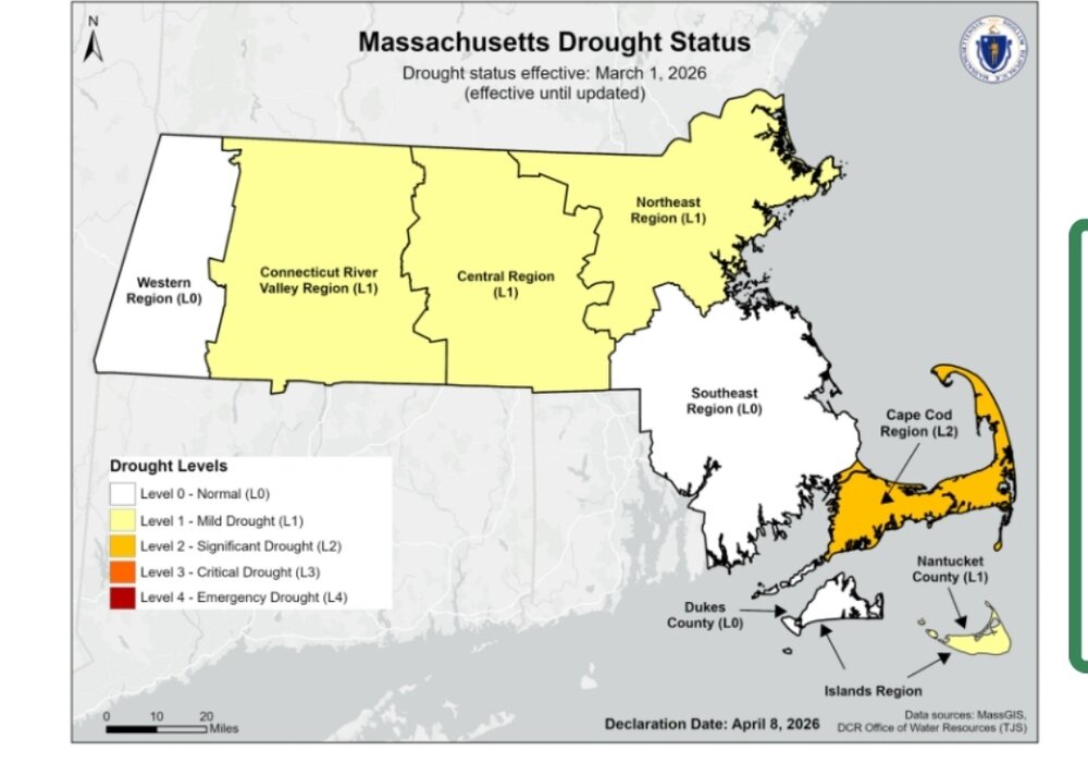
it literally says L2 sig drought for the cape
-
Naw I just like good pool weather.
-
They finally stopped with the drought nonsense.
-
32
-

2026-2027 El Nino
40/70 Benchmark replied to Stormchaserchuck1's topic in Weather Forecasting and Discussion
Yea, subtle shift with the "angle of the dangle" of that vortex, and whole new pattern. It was not only the -WPO ridge shifting east, but the /AONAO blocking dissipated, so we got the dreaded elongation of the "football" shaped PV.