All Activity
- Past hour
-
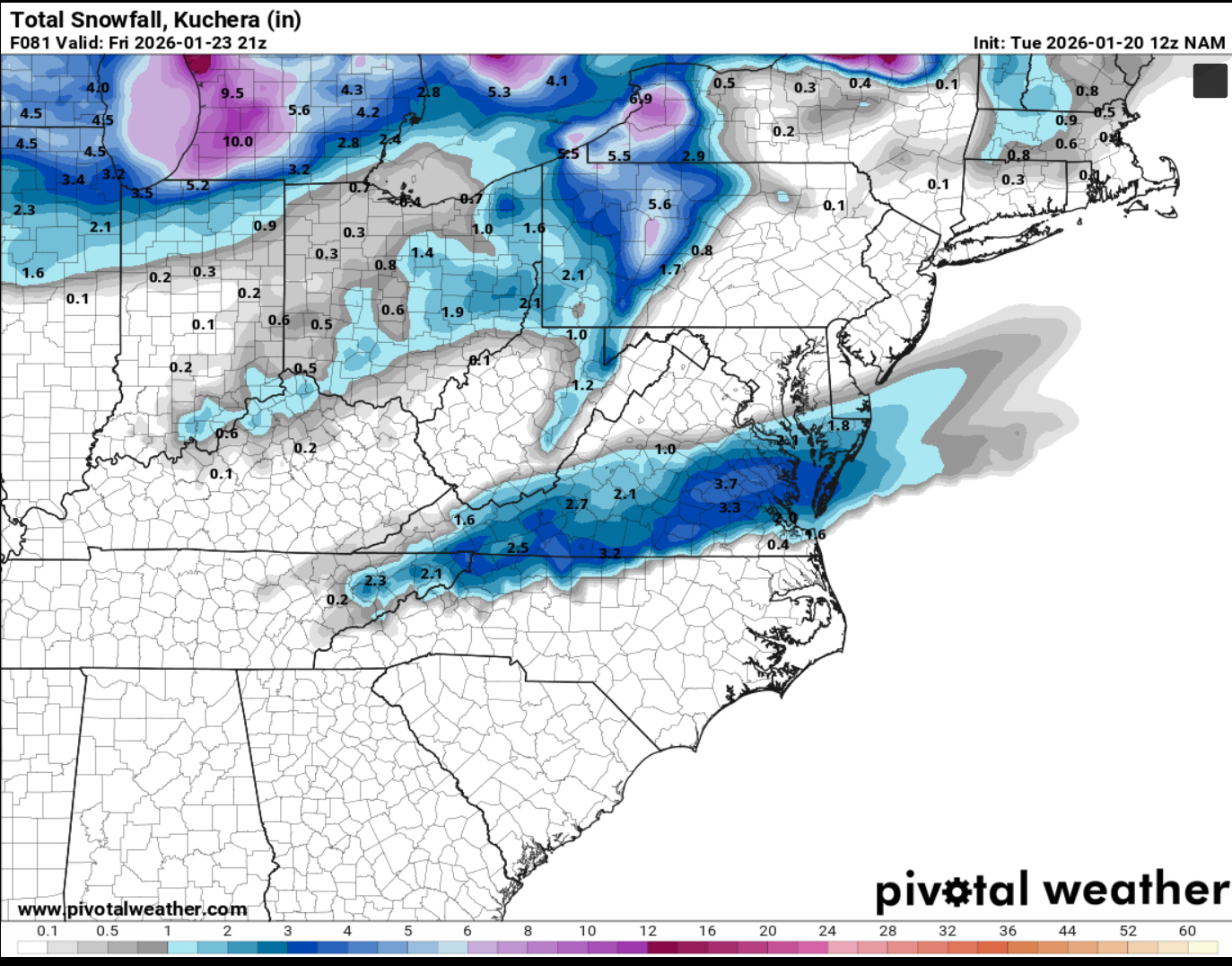
I would not say the ICON is North, it actually trended south from its run this morning which only went to hr 120, when compared to hr 114 on most current run. Also has been all over the place over the past 4 runs or so, I'd take the ICON with a grain of salt at this point until we get additional info.
-

January 25-26 Winter Storm Potential
coastal front replied to Ralph Wiggum's topic in Philadelphia Region
Me too . -

January 2026 regional war/obs/disco thread
Kitz Craver replied to Baroclinic Zone's topic in New England
This could get misleading as Ray said with southern peeps honking and others like meh -
I thought this month would finish cold in the eastern part of the US. With the cold coming late month, that doesn't look completely wrong. At worst, its delayed a week from what I thought. At best, the cold will be severe enough to make some areas cold by the end of the month. This event is behaving a lot more like a neutral than a La Nina to me. It's been very wet in the Southwest because the subtropical jet has been OK/feeding the polar jet at times. The warmth in the Northwest isn't really correlated to La Nina or -PDO either, same for the Northern Plains. But it's not really cold in the South like in an El Nino. The models continue to show a big snow/ice storm down to the Mexican border, deep into Texas and the Old South as well. That's not really super cannonical La Nina either - SE ridge usually blocks those outcomes. A lot of the great displaced to the south snow events are in super -WPO neutral events outside Nov/Feb-Apr windows - like the snows in Mexico City in the 1960s, or the snow to the Mexican border in Oct 2020, or the snow to the Santa Fe in Sept 2020. If we get another big precipitation event here (increasingly likely) the winter is basically guaranteed to be wetter than average, and this becomes one of the wettest Januaries in the past 100 years (we're already top 20). I think a lot of you guys live in a sort of perpetual state of delusion about what actually happens each winter. I saw the Don guy say something like "the Southwest will remain warm"....and its like yeah its been warm here. But the northwest/plains are running 10-15 above average in a -PDO, near La Nina. That's way more of a story than the Southwest being +7 in those conditions. A small area of the country ~55% of the way through Dec-Feb is running 1-3F below average. A comparable area of the Plains/NW is +9F or more above average. Meanwhile, the West has been pretty consistently wetter than the East, despite far greater warmth. The pattern essentially has been able to block cold to the West completely (sort of like 2017) but not moisture because there is some subtropical influence.
-
That's why I liked yesterday's suppressed looks.
-

Possible Record Breaking Cold + Snow 1/25 - 1/26
Stormlover74 replied to TriPol's topic in New York City Metro
Its crazy to think we don't want this coming too much further north but right now we still have a decent amount of wiggle room -

Central PA Winter 25/26 Discussion and Obs
WmsptWx replied to MAG5035's topic in Upstate New York/Pennsylvania
I would take die iKon. -
Baja low holding back a touch on the GFS at 54
-

Central PA Winter 25/26 Discussion and Obs
Superstorm replied to MAG5035's topic in Upstate New York/Pennsylvania
ICON north. . -

-
Just search for Allan Huffman on Twitter.
-
ICON is beautiful with … even more upside.
-
January 25-26 Winter Storm Potential
coastal front replied to Ralph Wiggum's topic in Philadelphia Region
Oh yeah the icon will do. Love the amped solution it’s just hoping it can stay there for 5 days lol . -

Possible Record Breaking Cold + Snow 1/25 - 1/26
guinness77 replied to TriPol's topic in New York City Metro
We are driving from Hartford back to Long Island on Sunday afternoon from my older’s volleyball tournament into the evening so…I’m fully expecting a storm and because we’ll be on the road, I’m taking full credit for it . -
Thanks. The Canadian inputs will be a nice touch, especially around the Great Lakes which we’ve seen with verification. Does better with LES physics and outputs absolutely bias low on the NBM 4.3 around that area. Also noticed the 5.0 biases low on these synoptic scale setups, but does do a solid job on the edges, so it’s give and take. We’ll be chatting as we get closer to implementation. Excited for the new changes in version 5.0. Back to your regularly scheduled programming.
-
Thru 42 gfs and euro h5 almost exactly the same in every way.
-

Richmond Metro/Hampton Roads Area Discussion
RVASnowLover replied to RIC Airport's topic in Mid Atlantic
It is the ICON so there is that. However, we do not want to see it phase more and try to become a coastal. Will be a snow to sleet event for sure if that happens. -
Another note on ICON: In the wake of that catastrophic icing all across the deep/mid-south, they'd have no power PLUS temps in the single digits. BAD!

-
Yeah. But you dont get the cool drifts.
-
Ratios are better without wind too.
-

Pittsburgh/Western PA WINTER ‘25/‘26
colonel717 replied to Burghblizz's topic in Upstate New York/Pennsylvania
Just minor changes...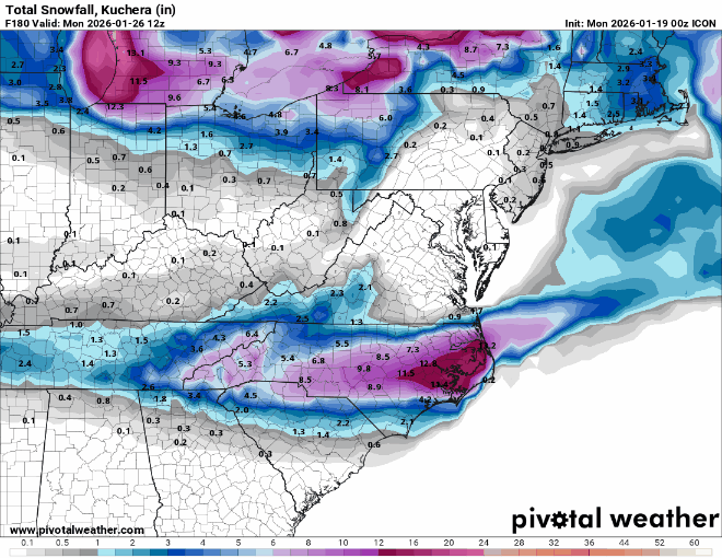
-
It sounds like the ICON solution featured a deepening coastal low that pulls in a warm nose for some. I haven't heard this scenario being mentioned on other guidance, so is this a new development? Could we see this pop up on other guidance?
-
ICON leads... will GFS/CMC/Euro/UKMET/AI's follow?
-

January 2026 regional war/obs/disco thread
ineedsnow replied to Baroclinic Zone's topic in New England
its coming! -
...and a fair share of ensembles.