All Activity
- Past hour
-
Governor Sherrill....Bueller, Bueller. First the power outages and now this and crickets. Could probably use a State of Emergency in a few counties about now.
-

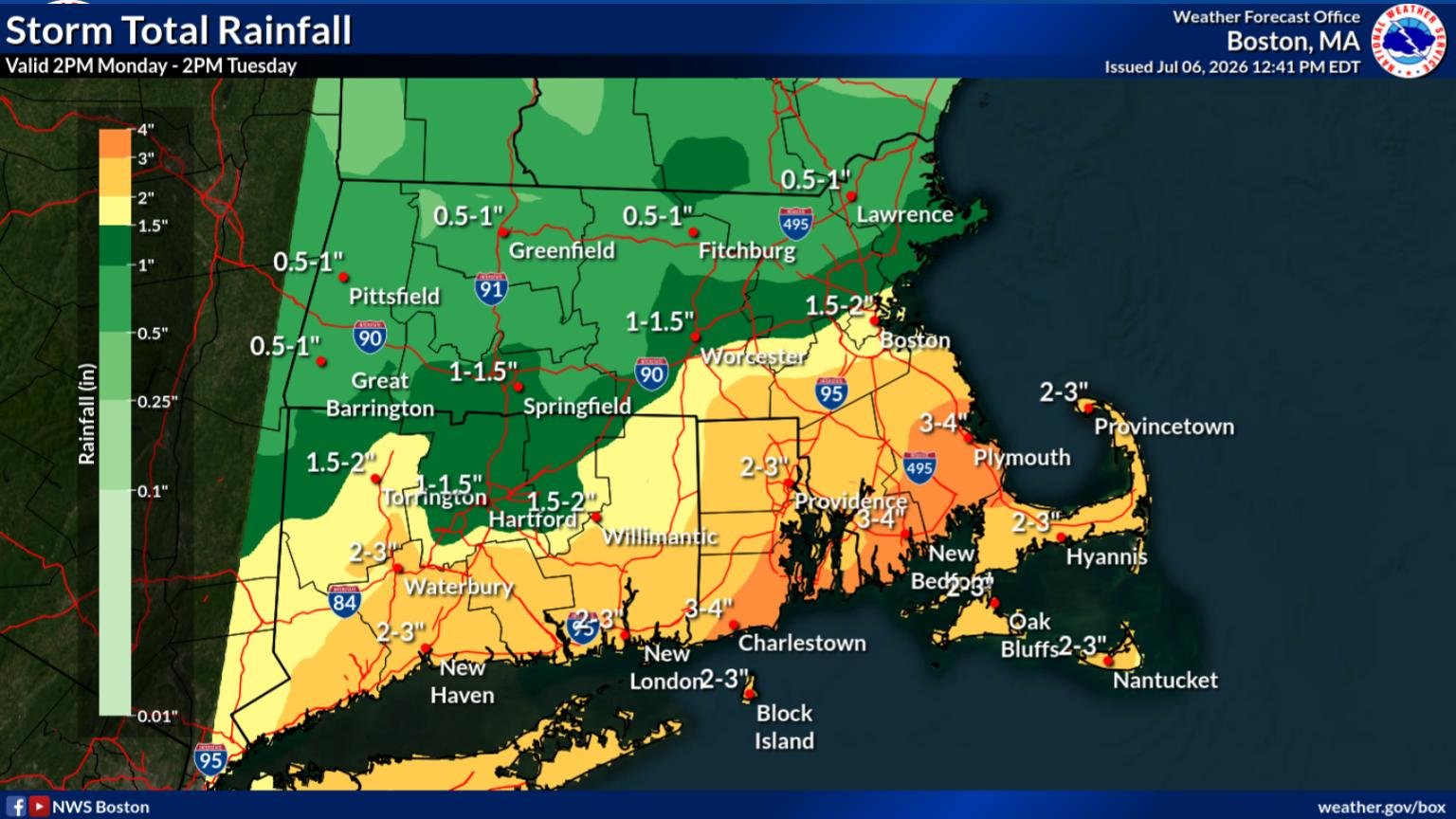
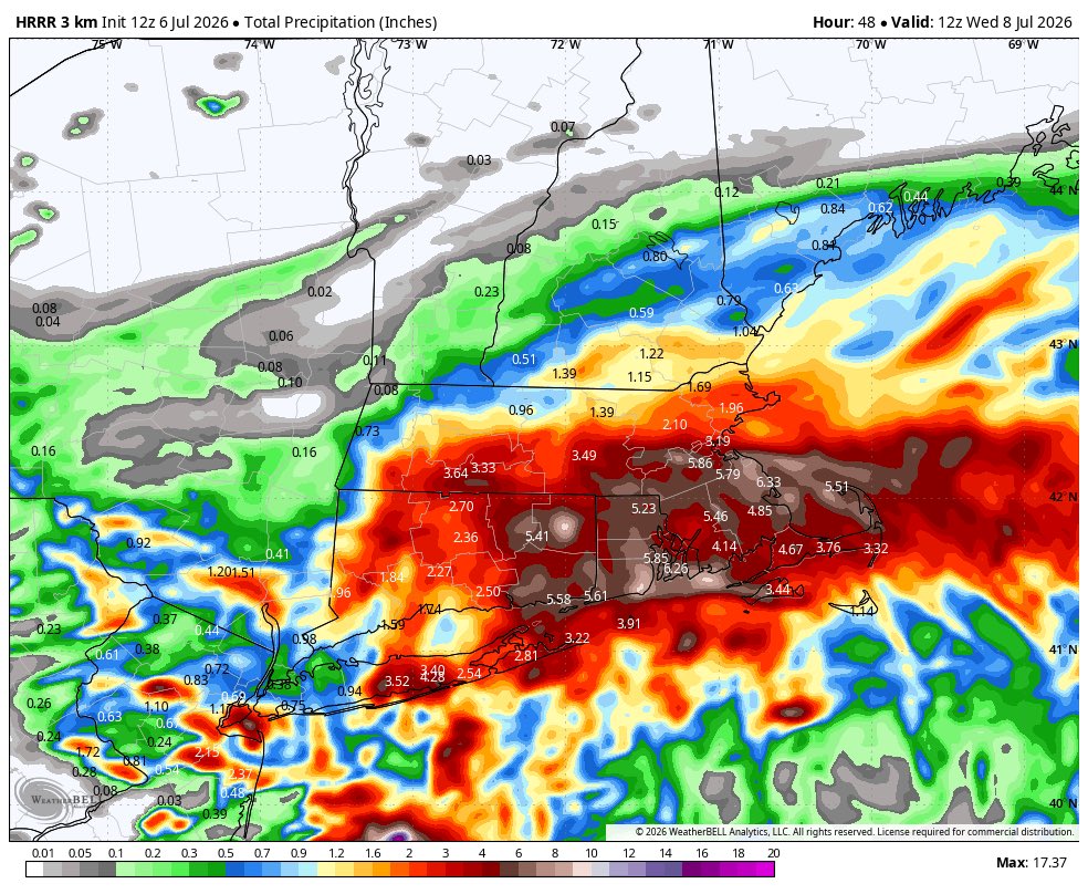
Hoisting the Sultan Signal: Heavy Rain Event July 5-7
Damage In Tolland replied to WxWatcher007's topic in New England
I’m not getting that but yes that is extremely boring . -
Otisville meso station recorded 8.09” for the past 24hr. Closest station to me in Sullivan south recorded 2.81”, north 0.62”. My totals are probably closer to 2-3”. Probably like the third or fourth time in the past half a dozen years I just barely avoid a substantial rainfall event to the north. edit: Otisville meso station is 25 miles from Eldred meso. It was close.
-

Hoisting the Sultan Signal: Heavy Rain Event July 5-7
kdxken replied to WxWatcher007's topic in New England
Not so sure about that. Hope you're right. -

Hoisting the Sultan Signal: Heavy Rain Event July 5-7
dendrite replied to WxWatcher007's topic in New England
The guy who enjoys 24hr 3sm -SN events in winter isn’t excited about 3-5” of rain in 24hrs? -
More downpours popped up in Mercer and Hunterdon, so hopefully we'll be getting more here in a little while.
-

Central PA Summer 2026 Discussion/Obs Thread
canderson replied to Voyager's topic in Upstate New York/Pennsylvania
No, but they said around the WCCC it’s the most extensive damage they’ve seen since Sandy. -
Impressive, the first round last night really made this happen.
-
Flood advisory heavy rain parked over the town of babylon
-
3.85” as of 1pm for the event total so far from 8pm last night. Currently light rain falling.
-
3.85” as of 1pm for the event total so far from 8pm last night. Currently light rain falling.
-
1" total at my house since last night. Crazy flash flooding in Monmouth County.
-
Guess I haven't seen the other - the actual area thing. Got a link? I'm wondering how they would define that. Presumably the 15% thing is because there's no well-defined line of the "edge of the ice" eventually the ice starts just breaking up into a bunch of floating icebergs, that extend out for hundreds or even thousands of miles (all the way down to Bermuda even sometimes); how would one measure the "area" of such a thing, especially on a daily basis? Would they just sum up the total of the surface area of all icebergs? (including "the big one in the middle") That seems like an impossible task.
-
.thumb.gif.f92b16c631a1d15d405ed77b33f0710d.gif)
Hoisting the Sultan Signal: Heavy Rain Event July 5-7
Torch Tiger replied to WxWatcher007's topic in New England
days n days type event. Sucks -

Central PA Summer 2026 Discussion/Obs Thread
Itstrainingtime replied to Voyager's topic in Upstate New York/Pennsylvania
Total rainfall yesterday was 3.34". An additional .03" fell since midnight. -

Hoisting the Sultan Signal: Heavy Rain Event July 5-7
TauntonBlizzard2013 replied to WxWatcher007's topic in New England
The orientation is likely going to end up the opposite of that. heaviest West, trailing off SE -
Over 2” in sw Nassua now. Rates have been consistently below what’s needed for real flash flooding. So it’s mainly a much needed good soaking .
-
Hoisting the Sultan Signal: Heavy Rain Event July 5-7
kdxken replied to WxWatcher007's topic in New England
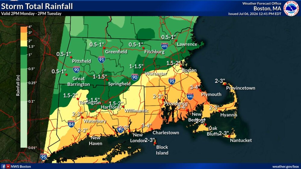
-

Hoisting the Sultan Signal: Heavy Rain Event July 5-7
Sey-Mour Snow replied to WxWatcher007's topic in New England
No doubt boring but beneficial yes -
https://newjersey.news12.com/2026/07/06/roof-collapses-at-bjs-wholesale-club-in-ocean-township/128UzlO4BAdoGypMDmXBA6 Multiple crews are responding to a roof collapse at a BJ’s Wholesale Club in Ocean Township. The Monmouth County Sheriff’s Office said first responders are on scene at the store on Route 35 in the Oakhurst section of Ocean Township. Officials are asking people to stay clear of the area so emergency crews can respond safely. The collapse happened around 11:30 a.m. Multiple mutual aid crews from surrounding towns were also called to the scene. Law enforcement officials told News 12 that there were no injuries reported. Police said all 27 staff members who were in the building at the time are accounted for and safe. All of the customers who were in BJ's at the time of the collapse are also safe, police said. According to Ocean Township Police Chief Michael Sorrentino and Monmouth County Sheriff Shaun Golden, approximately 20% of the rear of the building has collapsed. Officials believe the damage was caused by the weight of the water from the heavy rain that fell. Authorities are also urging drivers to avoid Route 35 because of severe flooding in the area. This remains a developing story.
-
1.61" here now as of 1 pm, pouring out
-
Todays storm has popped up right over my area and has been sitting here for a while. Heavy rain coming down but not much thunder and no severe aspects.
-
Hoisting the Sultan Signal: Heavy Rain Event July 5-7
kdxken replied to WxWatcher007's topic in New England
Guessing it's like the 12Z. Dumps "6 in on the wood yard. Better be way the hell off.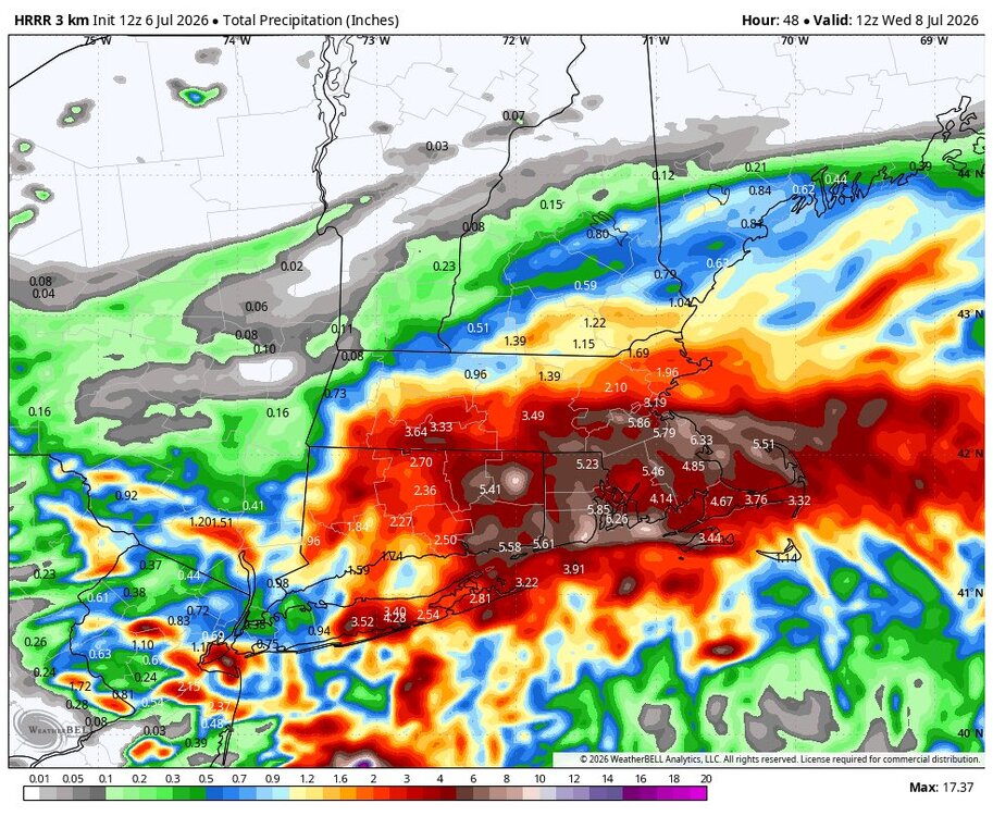
-

July 2026 General Discussion
TheClimateChanger replied to Chicago Storm's topic in Lakes/Ohio Valley
This is crazy. I didn't see anything about this until someone in the NE Ohio thread mentioned. -
Hoisting the Sultan Signal: Heavy Rain Event July 5-7
kdxken replied to WxWatcher007's topic in New England