All Activity
- Past hour
-
Despite 80-90% rain chances last night we’re sitting at 0.00” storm total here for the front
-
Snow season started great, with 8" paste T-Day night. The 9.3" fell on 12/4-5, bring the pack to 15", tops here for the date. Little did I know that the best was behind; that 4-5 event was the season's biggest and the remainder was mostly spent escaping from serious snowfalls. After the nice 6.3" fluff on 12/24, we had only one event greater than 4". No other winter here can claim that factiod.
-

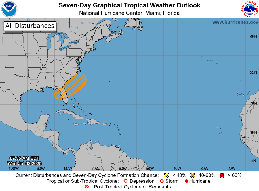
July 2025 Discussion-OBS - seasonable summer variability
bluewave replied to wdrag's topic in New York City Metro
This story is over 20 years old now and the tree growth has greatly increased since then. Central Park Weather: Vegetative Overgrowth Affecting Weather Readings - WABC-TV (New York-WABC, August 22, 2003) - Forecasting the weather is not easy. Government equipment can often be blamed for giving faulty weather information. As Bill Evans explains, a big culprit may be some of the equipment buried in Central Park. Rainfall, snowfall, and the temperature are all vital information recorded 24 hours a day at the weather station located in the heart of Central Park. But meteorologists like Michael Schlacter have serious concerns about the accuracy of the stations data. It sits amid overgrown vegetation and he says thats the problem. The leaves can trigger snow gauges and trees can warp rain and wind measurements. On this hot day, a temperature gauge is in the shade instead of direct sunlight. Michael Schlacter, Weather 2000: "Its kind of like driving a car without a speedometer, odometer, and gas gauge. You are running with false information." The weather instruments at Belvedere Castle have long adorned the top. There used to be a government meteorologist here in the city to keep an eye on them. But now the nearest meteorologist is 60 miles that way. But National Weather Service meteorologists say they knew the weather readings in the park would never be as keenly accurate as the ones at the airports where guidelines prevent foliage from being within 100 feet of the station. Schlacter: "We knew that at times we would have flaky readings, that leaves would fall in gauges, that we would have problems with visibility sensors." [NWS Meteorologist-in-Charge Michael] Wyllie says the weather station is there because it was historically significant to maintain its presence in the park. He says theres been a lot of growth because of the wet spring at so much in fact that temperatures have routinely been recorded lower in the park than at the airports. Wyllie: "We are actually having a micro climate system there because of the vegetation." Imperfect perhaps but nonetheless the system provides the official record of weather for the country's largest city. And Michael Schlacter says its a city that deserves better. Schlacter: "I think New Yorkers deserve a lot better, and I think they deserve the best weather station money can buy." Copyright 2003 ABC Inc., WABC-TV Inc. -

July 2025 Obs/Disco ... possible historic month for heat
moneypitmike replied to Typhoon Tip's topic in New England
Connecticut is the Philadelphia of New England in all seasons. -

Occasional Thoughts on Climate Change
TheClimateChanger replied to donsutherland1's topic in Climate Change
Will be interesting to see where June 2025 places. Looks like we won't beat 2021 but good chance to finish in the top 5. It should be noted that 2021 is the warmest by a long shot, as you can see on the temperature plot below. Last year finished in second place. Below is an article from the Washington Post on the heat in June, with a map showing temperature anomalies. Per the article, above is +1 to +3, and well above +3 or better. If this is line with NCEI's final numbers, the CONUS temperature would certainly place in the Top 10 warmest. Like I said 2021 looks hotter on my glance at the data, but probably not too far from last year's final tally. I compared the map below to 2022 [11th hottest June] and this map is clearly warmer than that month. In 2022, the only widespread area of +3F or greater anomalies was in Texas and scattered locations along the Gulf Coast and in the Southwest. This year saw widespread 3F or greater anomalies throughout the interior west, the Upper Ohio Valley, parts of the Great Lakes and Mid-Atlantic. June was hotter than usual, and humid. See where your area ranks. - The Washington Post Here's what 2022 [11th place] looks like on NCEI divisional maps, with the same anomaly convention [+1, +3, -1, -3]: -
.75 here last 24 hours but those two areas to my SW and South have scored with over 1.50 and 2 inches. Bethany Beach with over 4.9 inches of rain this week. Will add to that today and the final push of convection moves East and then offshore.
-
Yeah, impressive 500 mb height rises to the north and east of New England during the hurricane season has been steering all the major hurricanes into the Gulf and Florida since the 1990s.

-

2025 Lawns & Gardens Thread. Making Lawns Great Again
tamarack replied to Damage In Tolland's topic in New England
We're already in trouble. But not because of a carpet of oak germinants - 99.9% will die due to insufficient sunlight. -

Occasional Thoughts on Climate Change
Typhoon Tip replied to donsutherland1's topic in Climate Change
https://phys.org/news/2025-07-fossils-earth-famous-extinction-climate.html Particularly alarming when the study cites destruction of the tropical flora band, which is precisely what anthropomorphic influence is doing -

2025-2026 ENSO
Stormchaserchuck1 replied to 40/70 Benchmark's topic in Weather Forecasting and Discussion
Didn't realize the AO was so + in the middle of Winter last year. -
Station stats for June... Tied for 6th warmest past 48 years ( last year was warmest ). 3rd driest with 1.47" rain . I think that the last 10 months going back to September was quite possibly the boringest stretch of weather I can remember. Four of those months had record or near record dryness .
-

July 2025 Obs/Disco ... possible historic month for heat
forkyfork replied to Typhoon Tip's topic in New England
when i was a kid 70 degree dewpoints felt special -
I finished June with 10.81" of rain. Still too wet to cut portions of the yard. Looks like CLE only had half of that amount. Most of the storms just missed CLE to the South and East.
-
While we haven't seen much smoke in a few weeks, with a return to more of a northwesterly flow pattern, some smoke and haze aloft is evident on visible satellite imagery this morning across southern parts of Canada, the Upper Peninsula of Michigan and northern lower Michigan. Shouldn't be a huge deal but the HRRR-Smoke does show some elevated levels of near surface smoke for northeast North Dakota and far northern Minnesota later today.
- Today
-
I guess Bubb wouldn’t be watering his grass this week. just picked up a trailer of much to keep me busy this weekend. Got to spread mulch while the sun is shining 66 degrees for the low this morning.
-

July 2025 Obs/Disco ... possible historic month for heat
CoastalWx replied to Typhoon Tip's topic in New England
Looks like we have a cat 5 coming up the coast. -

July 2025 Obs/Disco ... possible historic month for heat
metagraphica replied to Typhoon Tip's topic in New England
Damn, I need a good heavy rain like that down here. only .5 spread out over more than 12 hours. -
July 2025 Obs/Disco ... possible historic month for heat
CoastalWx replied to Typhoon Tip's topic in New England
They do, Brian and I were just mentioning how infrequent it is now. -

July 2025 Discussion-OBS - seasonable summer variability
SACRUS replied to wdrag's topic in New York City Metro
Mainly southern rains the next few hours till late morning. -

July 2025 Obs/Disco ... possible historic month for heat
ineedsnow replied to Typhoon Tip's topic in New England
-
July 2025 Discussion-OBS - seasonable summer variability
SACRUS replied to wdrag's topic in New York City Metro
Records: Highs: EWR: 102 (1966) NYC: 100 (1966) LGA: 101 (1966) JFK: 101 (1966) Lows: EWR: 56 (2001) NYC: 56 (2001) LGA: 58 (2001) JFK: 56 (2001) Historical: 1833 - An unusually large New England tornado, one half to three quarters of a mile wide, went from Salem Pond to Norton Pond, VT, and then into Canada. It prostrated nearly everything in its path. (The Weather Channel) 1833: The following is from the "History and Description of New England" published in 1860: "On the 2nd of July, 1833, this town (Holland, Vermont) was visited by a violent tornado, which commenced on Salem Pond in Salem, and passed over this place in a northeasterly direction. It was from half to three-quarters of a mile wide and prostrated and scattered nearly all the trees, fences, and buildings in its course. It crossed the outlet of Norton Pond and passed into Canada, and its path could be traced through the forests nearly to Connecticut River." 1843 - An alligator reportedly fell from the sky onto Anson Street in Charleston, SC, during a thunderstorm. (David Ludlum) 1944: Today began the longest dry spell in Las Vegas, NV history which lasted until October 10th, a total of 101 days. (Ref. Wilson Wx. History) 1932: Boston, Massachusetts recorded its lowest pressure 29.21 inches of mercury for the month of July. (Ref. NOAA Boston Weather Events) 1965: A cool morning 50° at Sterling, 61° at DCA. A cool 51° minimum temperature equaled July record low on 15th in 1940 in Richmond, VA. (Ref. Richmond Weather Records - KRIC) 1972: Large hail and damaging winds accompanied severe thunderstorms across parts of central Oklahoma. Baseball-size hail fell in the Oklahoma City metropolitan area, and winds reached 75 to 100 mph. The wind took down power lines and damaged or destroyed at least 23 mobile homes. Winds gusted to 100 mph at Lindsay, and 80 mph at Norman. The wind in these areas mainly damaged trees and blew down power lines, but also damaged a few roofs. (Ref. Wilson Wx. History) 1980: Wichita Falls, TX broke their old record by 10 degrees as the temperature hit 114°. This was the 9th consecutive day of temperatures above 100°. (Ref. Wilson Wx. History) 1986: Amazingly, an F2 tornado at Jacksonville, NC that killed three people was the deadliest twister of the year as the United States experienced only 15 tornado deaths during the year. This was an all-time low since records began in 1916. (Ref. Wilson Wx. History) 1987 - Thunderstorms in Colorado produced hail as large as golf balls northwest of Kiowa, which accumulated to a depth of twelve inches. Hail two and a half inches in diameter was reported at Black Forest. Hail damaged 900 acres of crops south of the town of Wiggins. (The National Weather Summary) (Storm Data) 1988 - Twenty-six cities in the eastern U.S. reported record low temperatures for the date. The morning low of 47 degrees at Roanoke, VA, broke the July record set the previous day. (The National Weather Summary) 1989 - Thunderstorms produced severe weather in the south central U.S., with 158 reports of large hail and damaging winds through the day. Evening thunderstorms in northeastern Texas produced softball size hail which caused more than five million dollars damage at Allen, and wind gusts to 90 mph at Dallas, which injured eight persons and caused seven million dollars damage. Winnfield LA reported 29.52 inches of rain in six days, for a total of 62.50 inches for the first six months of the year. Midland, TX, reported an all-time record high of 112 degrees. (Storm Data) (The National Weather Summary) 1992: An usually cold air mass for the time of year was in place across northern New York and Vermont. Saranac Lake, NY dipped to 30°. An observer in West Charleston, VT dropped to 30° as well with widespread frost and a frozen garden hose. A total of six cooperative observer stations in Vermont reported freezing low temperatures with East Haven reporting the lowest with 29°. Burlington, VT set a record low with 40°. (Ref. Wilson Wx. History) 1994: A US Air jet crashed near Charlotte, NC during a thunderstorm. The cause of the crash was officially listed as wind shear. Major efforts to understand and avoid wind shear have resulted in a dramatic reduction in the number of air accidents involving this deadly phenomenon. (Ref. Wilson Wx. History) 2001: In Michigan, frost and freezing temperatures were observed in some locations with Grant dropping to 29 degrees. Muskegon reported their coldest July temperature on record with 39 degrees. Other daily record lows included: Lansing: 38, Muskegon: 39, Flint: 40, Youngstown, Ohio: 40, and Grand Rapids, Michigan: 43 degrees. 2003: Thunderstorm wind gusts to 75 mph at Bigfork, MN, blew off the top of a tree, which went through the windshield of a car and impaled the driver in his seat; he lived. At Basswood Lake, a storm gust toppled a tree onto a tent; 1 camper killed and 1 hurt. (Weather Guide Calendar with Phenomenal Weather Events 2011 Accord Pub. 2010, USA) 2004: It was about a half hour into the storm that my grandmother recalls hearing what she calls a "blood curtailing scream" coming from me. She looked over to see me lifted from about 6 inches off the ground and dropped back down again. At first she though I had just become scared and jumped as she could tell that the lightning had struck not to far away. Read the full story at the following Ref. (Ref. A Lightning Survivor) 2007: All-time record dew point depression set at las vegas today June 27, 2011 at 432 PM PDT today the dew point depression at Mccarran International Airport in Las Vegas reached 129 degrees. The dew point depression is defined as the difference between the air temperature and the dew point temperature. In the case of today the air temperature was 107 degrees at 432 PM and the dew point temperature was -22 degrees. This made for a relative humidity of 1 percent at the time. The previous all-time record dew point depression for Las Vegas was 120 degrees set on July 2, 2007. The above information is preliminary and is subject to a final review before being certified by the national climatic data center. (Ref. NWS - A New Record To Be Certified) 2019: Measurable rain fell at the Richmond International Airport for the first time in 13 days. The drought began on June 20th and ended on July 3, 2019. (Ref. NWS - The Richmond International Airport Records) -
1.70 - More than a inch fell at some point late over night or very early this morning...
-
Noticed that two days ago. I had to go to the next radar site to the West. Always seems to be an issue.
-

July 2025 Obs/Disco ... possible historic month for heat
HoarfrostHubb replied to Typhoon Tip's topic in New England
Sunday and Monday still look nice. Hot!! -
July 2025 Obs/Disco ... possible historic month for heat
HoarfrostHubb replied to Typhoon Tip's topic in New England
They still happen. But less frequently.


