All Activity
- Past hour
-
41F here.
-

Spooky Season (October Disco Thread)
kdxken replied to Prismshine Productions's topic in New England
Something will come to replace it. -
First 30s of the season IMBY
-
Over the last several years the New Foundland warm pool has been a precursor to -NAO linking up with the SE ridge/WAR
-

Spooky Season (October Disco Thread)
CoastalWx replied to Prismshine Productions's topic in New England
At least we can put the 360hr fantasies to bed. -
Spooky Season (October Disco Thread)
CoastalWx replied to Prismshine Productions's topic in New England
Breezy and 45. -

Spooky Season (October Disco Thread)
Modfan2 replied to Prismshine Productions's topic in New England
Nice rad cooling, down to 36F. Now to add winds to the mix today to make it feel chilly today - Today
-
0Z Icon: big change from prior runs with virtually no sfc low and the main part of its H5 vorticity recurves sharply into Haiti It almost looks like a split with something else weak going into SW Caribbean headed for Nicaragua/Costa Rica. UKMET still has yet to have a run with a TCG in the Caribbean from this. CMC: has yet to have a TCG in the Caribbean as it once again has TCG E of the Car that heads through the Lesser Antilles; ends in W Caribbean as a weakening low GFS: TCG S of Dom. Republic; moves slowly N to E tip of Dom. Republic and then accelerates NNE OTS Euro: it again pretty similarly takes its time as prior runs with a TCG not til ~10/23-4 in SW Caribbean with a N move to W. Jamaica and C. Cuba followed by NNE recurve to C. Bahamas. Cat 2 H C Cuba to C Bahamas. At 2AM, it still didn’t make the TWO.
-
20th. So many snow events on January 20th.
-

Spooky Season (October Disco Thread)
dendrite replied to Prismshine Productions's topic in New England
All nighter then? -
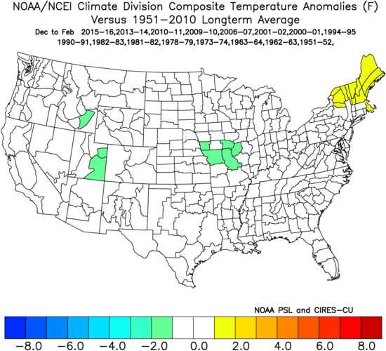
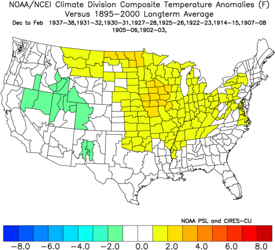
The answer is no. Winters following no Conus H hit seasons haven’t been far colder on average and not even frequently colder. First of all, keep this in mind: since 1851 there have been 34 (20%) seasons with no Conus H impact on record. Of these 34, there were only 6 during La Niña (1872, 1890, 1892, 1973, 2000, and 2010) vs a much higher 15 during El Niño, which is intuitive. So, one needs to keep in mind that winters following no Conus H hit years are biased toward El Niño/away from La Niña. ————————— Winters since 1950 following no Conus H hit seasons: a mix 2015-6: mild 2013-4: cold 2010-1: cold 2009-10: cold 2006-7: normal 2001-2: mild 2000-1: cold 1994-5: mild 1990-1: mild E; cold W 1982-3: mild 1981-2: cold 1978-9: cold 1973-4: mild 1963-4: cold 1962-3: cold E, mild W 1951-2: mild E; cold W Of 16 winters in E half of US, 8 were cold, 7 were mild, and 1 was normal…so no signal W half of US: 9 cold, 6 mild, 1 normal…ever so slight cold signal in W Here’s the map for all 16 winters since 1950 combined: near normal nationwide/no cold signal at all: ————— *Edit: here’s the avg for 10 winters following no Conus H hit seasons 1895-1949: actually leaned slightly mild 1937-8: normal E; mild W 1931-2: mild E; cold W 1930-1: mixed 1927-8: mixed 1925-6: cold E; mild W 1922-3: mixed but mainly mild 1914-5: cold 1907-8: mainly mild 1905-6: mixed but mainly mild 1902-3: mixed but mainly cold
-

Spooky Season (October Disco Thread)
Diggiebot replied to Prismshine Productions's topic in New England
Gfs shifting so much makes me think the gfs is up to gfs things. General pattern looks more favorable than any threat this whole season. -

E PA/NJ/DE Autumn 2025 Obs/Discussion
MGorse replied to PhiEaglesfan712's topic in Philadelphia Region
An area of stronger 925 mb cold air advection (25-35 knots of wind at this level) crossing the region late this evening. -
Spooky Season (October Disco Thread)
dendrite replied to Prismshine Productions's topic in New England
Will some stay up tonight for the 00z euro? -
Low is our current temp of 55 after a high of 67. Clouds hung tight until around 4:30 when the sun finally came after after being cloudy since Saturday afternoon.
-
-

E PA/NJ/DE Autumn 2025 Obs/Discussion
Birds~69 replied to PhiEaglesfan712's topic in Philadelphia Region
As soon as the sun went down the winds picked up. Definitely some 20mph+ gust... -
Yeah, I don’t understand either. But look at the example I posted, and check others, and you’ll see, in a number of cases, it’s not a simple arithmetic average. And in some cases, diverges significantly (almost always warmer than the mean).
-
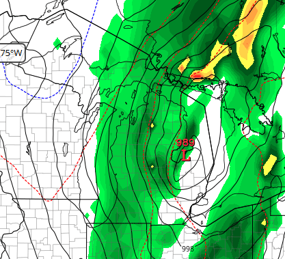
Euro weakest sauce at 989 mb for Sunday
-
It has but not ideal. These mosquitoes need to go
-
speaking of the jan 96 blizzard, what happened to that late february storm that prevented something like that from happening? was it just classic nina tendencies? in other words, what went wrong?
-
It doesn't look like it will be.
-
Yup… The north pacific just never coupled with the enso. Then we got lucky with the Atlantic also. It’s happened recently in ninos also where the pacific pattern never took on a canonical Nino configuration. It was just a fluke. A Nina that didn’t act like a Nina. It happens but it’s not something I’d ever expect again. If it does happen again great but I’d never predict it before hand.
-
I don’t know about you but all of this should be solely based on hour 84 NAM extrapolations. From what I’m seeing expect a big snow January 18th
-

E MDR AEW: models support Car. TCG next wk
NorthHillsWx replied to GaWx's topic in Tropical Headquarters
Someone needs to take the GFS out back and put it down like old yeller


