All Activity
- Past hour
-
SW CT and the New Haven area have mostly non profit water companies with dirt cheap water. I run my irrigation every day and it adds maybe $40 to my bill. I think a CCF which is like 750 gallons cost me like $2.
-
Looks like 3rd and 4th went from promises of Coc k to afternoon/ evening storms , sounds awesome . Thanks @ineedsnow
-
Tomorrow seems Stein for many in SNE anyway
-
Tomorrow seems meh for storms. Wonder if the early morning stuff limits some heating. Kind of looks messy overall.
-
My lawn is good so far. Haven’t watered much. You guys missed out on some rogue stuff this month too.
-
 DCA _ NYC _ BOS ___ ORD _ ATL _ IAH ___ DEN _ PHX _ SEA 1.8 2.0 2.5 1.5 1.5 0.5 0.3 1.2 2.4
 -
Does it work?
-
Mosquitos, gnats and ticks out of control this year.
-
68 and sunny out. Atlantic County was getting hit hard this morning with thunderstorms.
-
after the beginning of the week storm, looking like a pretty nice stretch through the holiday weekend. Finally a summer holiday i can breakout the american flag speedo and not sit around the pool in hunting ear
-
General observation while in SW connecticut this weekend. Son had a lacrosse tournament in Darien/New Canaan area. Barring the extreme wealth and nearly every home probably having a well, overall its just much greener than Eastern mass. We never get thunderstorms anymore. Tuesdays threat looks like it stops in Worcester as does most threats. Every summer we start off strong in the spring and then it turns into a dust bowl in EMA. Lawns are complete toast here already.
-
10 days since our last rain and still just 1.83” for the month looks likely to be our total
-
Measuring the temperatures under a mature stand of trees will always be 3° to 5° cooler than in a grassy clearing on sunny and warm days. NYC was usually pretty close to the surrounding sites like Newark from 1936 to 1980. This is when the thermometer wasn’t underneath trees. Many of the 100°+ readings from that era would have only been 98°-99°with a similar sitting to what NYC has seen since the increased tree growth in the last 10 years. Tree growth was slowly becoming an issue from the 1980s into the early 1990s. Then there was a greater shift in 1995 when the new ASOS was installed. This became much more pronounced since 2014 along with the continuing tree growth. Monthly Data for July 1936 for Upton NY NWS CWA Click column heading to sort ascending, click again to sort descending. NJ PLAINFIELD COOP 106 NY NY CITY CENTRAL PARK WBAN 106 NY PORT JERVIS COOP 105 NJ ELIZABETH COOP 105 NJ JERSEY CITY COOP 105 NJ LITTLE FALLS COOP 105 NJ PATERSON COOP 105 NJ CHARLOTTEBURG RESERVOIR COOP 105 NY SCARSDALE COOP 105 NY BEDFORD HILLS COOP 105 NJ NEWARK LIBERTY INTL AP WBAN 104 NY FLUSHING COOP 104 NY WEST POINT COOP 104 NY MOUNT VERNON COOP 103 NY HICKSVILLE COOP 103 NY CARMEL COOP 103 CT WATERBURY ANACONDA COOP 103 CT WATERBURY CITY HALL COOP 103 Monthly Data for July 1949 for Upton NY NWS CWA Click column heading to sort ascending, click again to sort descending. NJ NEWARK LIBERTY INTL AP WBAN 105 NJ PATERSON COOP 105 NJ PLAINFIELD COOP 104 CT MOUNT CARMEL COOP 104 CT NORWALK COOP 102 NJ CANOE BROOK COOP 102 NY NY CITY CENTRAL PARK WBAN 102 NJ RUTHERFORD COOP 102 CT WATERBURY ANACONDA COOP 102 NY SCARSDALE COOP 101 NJ ELIZABETH COOP 101 NJ RIDGEFIELD COOP 101 CT WATERBURY CITY HALL COOP 101 NY DOBBS FERRY-ARDSLEY COOP 100 NY WEST POINT COOP 100 CT GREENWICH COOP 100 CT BRIDGEPORT COOP 100 NY BEDFORD HILLS COOP 100 NY WESTCHESTER CO AP WBAN 100 NY LAGUARDIA AIRPORT WBAN 100 Monthly Data for September 1953 for Upton NY NWS CWA Click column heading to sort ascending, click again to sort descending. NJ PATERSON COOP 106 NJ PLAINFIELD COOP 105 NJ ELIZABETH COOP 105 NJ NEWARK LIBERTY INTL AP WBAN 105 NJ LITTLE FALLS COOP 105 NY WEST POINT COOP 105 NJ WANAQUE RAYMOND DAM COOP 104 NY SUFFERN 2 E COOP 104 NY PORT JERVIS COOP 103 NY NEW YORK LAUREL HILL COOP 103 NJ ESSEX FELLS SERVICE BLDG COOP 103 NY NORTHPORT COOP 103 NY BEDFORD HILLS COOP 103 NY CARMEL COOP 103 CT WATERBURY ANACONDA COOP 103 NY NY WESTERLEIGH STAT IS COOP 102 NY LAGUARDIA AIRPORT WBAN 102 NY NY CITY CENTRAL PARK WBAN 102 NJ RIDGEFIELD COOP 102 NY STEWART FIELD WBAN 102 NY WALDEN 2 NE COOP 102 CT NORWALK COOP 102 NY SCARSDALE COOP 102 NY DOBBS FERRY-ARDSLEY COOP 101 CT STAMFORD COOP 101 CT NORWICH 5 SW COOP 101 NJ CHARLOTTEBURG RESERVOIR COOP 100 NY OSSINING SING SING COOP 100 NY MIDDLETOWN 2 NW COOP 100 NY FARMINGDALE 2 NE COOP 100 CT DANBURY COOP 100 NY WESTCHESTER CO AP WBAN 100 Monthly Data for August 1955 for Upton NY NWS CWA Click column heading to sort ascending, click again to sort descending. NJ PLAINFIELD COOP 103 NJ ELIZABETH COOP 103 NJ PATERSON COOP 103 NY HEMPSTEAD MALVERNE COOP 103 NY PORT JERVIS COOP 102 NJ LITTLE FALLS COOP 102 NY NEW YORK FLOYD BENNETT FIELD WBAN 101 NY NEW YORK LAUREL HILL COOP 101 NY DOBBS FERRY-ARDSLEY COOP 101 NY WEST POINT COOP 101 NY CARMEL COOP 101 NJ JERSEY CITY COOP 100 NJ NEWARK LIBERTY INTL AP WBAN 100 NY NY WESTERLEIGH STAT IS COOP 100 NY LAGUARDIA AIRPORT WBAN 100 NY NY CITY CENTRAL PARK WBAN 100 NJ RIDGEFIELD COOP 100 NJ ESSEX FELLS SERVICE BLDG COOP 100 NJ WANAQUE RAYMOND DAM COOP 100 NY SUFFERN 2 E COOP 100 NY WALDEN 2 NE COOP 100 Monthly Data for July 1966 for Upton NY NWS CWA Click column heading to sort ascending, click again to sort descending. NY LAGUARDIA AIRPORT WBAN 107 NJ NEWARK LIBERTY INTL AP WBAN 105 NY NEW YORK AVE V BROOKLYN COOP 105 NY JFK INTERNATIONAL AIRPORT WBAN 104 NY ISLIP-LI MACARTHUR AP WBAN 104 NY PORT JERVIS COOP 104 NY NEW YORK LAUREL HILL COOP 104 NJ LITTLE FALLS COOP 104 NY WEST POINT COOP 103 NY MINEOLA COOP 103 CT NORWALK GAS PLANT COOP 103 NJ ELIZABETH COOP 103 NJ CANOE BROOK COOP 103 NY NY CITY CENTRAL PARK WBAN 103 NJ ESSEX FELLS SERVICE BLDG COOP 103 NJ PATERSON COOP 103 Monthly Data for July 1977 for Upton NY NWS CWA Click column heading to sort ascending, click again to sort descending. NY NEW YORK LAUREL HILL COOP 104 NY NY CITY CENTRAL PARK WBAN 104 NY DOBBS FERRY-ARDSLEY COOP 103 NJ NEWARK LIBERTY INTL AP WBAN 102 NJ TETERBORO AIRPORT WBAN 102 CT NORWALK GAS PLANT COOP 102 NJ ESSEX FELLS SERVICE BLDG COOP 101 NY WEST POINT COOP 101 NY VANDERBILT MUSEUM COOP 101 NJ PLAINFIELD COOP 100 NJ CRANFORD COOP 100 NY NEW YORK AVE V BROOKLYN COOP 100 NY NY WESTERLEIGH STAT IS COOP 100 NJ LITTLE FALLS COOP 100 NY MARYKNOLL COOP 100 CT STAMFORD 5 N COOP 100 NY SCARSDALE COOP 100 CT NEW HAVEN COOP 100 CT MIDDLETOWN 4 W COOP 100 NJ CANOE BROOK COOP 99 NY LAGUARDIA AIRPORT WBAN 99 NJ WANAQUE RAYMOND DAM COOP 99 NY SUFFERN COOP 99 CT DANBURY COOP 99 NY WESTCHESTER CO AP WBAN 99 Monthly Data for July 1980 for Upton NY NWS CWA Click column heading to sort ascending, click again to sort descending. NY DOBBS FERRY-ARDSLEY COOP 104 NY NEW YORK LAUREL HILL COOP 104 NJ PLAINFIELD COOP 102 NJ CRANFORD COOP 102 NY NY WESTERLEIGH STAT IS COOP 102 NY NY CITY CENTRAL PARK WBAN 102 NJ LODI COOP 102 NJ TETERBORO AIRPORT WBAN 102 NJ WANAQUE RAYMOND DAM COOP 101 NJ NEWARK LIBERTY INTL AP WBAN 101 NY NEW YORK AVE V BROOKLYN COOP 101 NJ ESSEX FELLS SERVICE BLDG COOP 101 NJ LITTLE FALLS COOP 101 CT NORWALK GAS PLANT COOP 101 NY SCARSDALE COOP 101 NY WEST POINT COOP 100 NJ CANOE BROOK COOP 100 CT NEW HAVEN COOP 100 CT NORWICH PUBLIC UTILITY PLANT COOP 100 NY LAGUARDIA AIRPORT WBAN 99
-
Insurance companies are like crime syndicates.
-
Low of 54 overnight. Should add 30-33 degrees today. Great pool weather.
-

July 2025 Discussion-OBS - seasonable summer variability
Dark Star replied to wdrag's topic in New York City Metro
Thank goodness. At my age, sustained heat might be the final nail... -
Up to 72.9F on the month at PIT for the mean temperature, matching 1994 as the highest in June since 1967 (73.0F) and surpassing last year’s final average by 0.1F. Pretty impressive turnaround considering the cold start to the month - we had accumulated an aggregate deficit of 22F from the normal value in just the first 2 days of the month.
- Today
-

E PA/NJ/DE Summer 2025 Obs/Discussion
BBasile replied to Hurricane Agnes's topic in Philadelphia Region
.thumb.jpg.9654c8f1ffd549623ce3c7c43c0c263e.jpg)
.thumb.jpg.c2f3d4f86067a4654d799040ba72ae8d.jpg)
-
Lotta purple showing up on 3k for Tuesday.
-
Hazardous Weather Outlook National Weather Service State College PA 618 AM EDT Mon Jun 30 2025 PAZ004>006-010>012-017>019-024>028-033>037-041-042-045-046-049>053- 056>059-063>066-011030- Warren-McKean-Potter-Elk-Cameron-Northern Clinton-Clearfield- Northern Centre-Southern Centre-Cambria-Blair-Huntingdon-Mifflin- Juniata-Somerset-Bedford-Fulton-Franklin-Tioga-Northern Lycoming- Sullivan-Southern Clinton-Southern Lycoming-Union-Snyder-Montour- Northumberland-Columbia-Perry-Dauphin-Schuylkill-Lebanon-Cumberland- Adams-York-Lancaster- 618 AM EDT Mon Jun 30 2025 This Hazardous Weather Outlook is for central Pennsylvania. .DAY ONE...Today and tonight. Strong to severe thunderstorms capable of producing damaging winds and heavy rainfall are possible this afternoon and evening. .DAYS TWO THROUGH SEVEN...Tuesday through Sunday. Strong to severe thunderstorms capable of producing damaging winds and heavy rainfall are possible during the afternoon and evening on Tuesday, especially across the Lower Susquehanna Valley.
-

July 2025 Discussion-OBS - seasonable summer variability
IrishRob17 replied to wdrag's topic in New York City Metro
The last weekend without any sort of precipitation IMBY was 3/7-3/9/25…could the first weekend in July finally end that streak? -
64 degrees this morning. 5.15 “ for the month of June so far, which puts us above average. Normal value 3.72” 89 degrees yesterday
-
Emphatically agree. My brother discovered a dead one in his kid's play area scattered among their stuffed animals/toys and had to do a rabies course for the whole family. Not a pleasant experience. Cost him a couple thousand bucks, and his insurance was billed a couple hundred thousand.
-
Need to be in and up for the 3x it snows and matters in winter
-
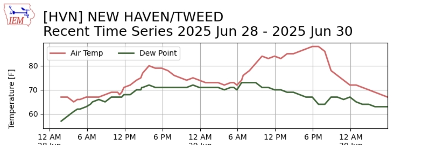
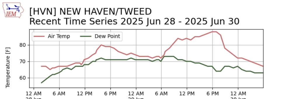
You need to move down to the shoreline. Just got back from another special 5 miler along the shoreline. Expect a typical warm and humid summer day region wide. The region will be just north or along the northern periphery of a stalled frontal boundary to the immediate south. Dew point readings will be primarily in the middle and upper 60s through the early afternoon. A sea breeze gets going for the afternoon and will usher in slightly higher moisture values with dew points approaching 70 late in the day and evening along far southern locations


.thumb.png.4150b06c63a21f61052e47a612bf1818.png)