All Activity
- Past hour
-

Mid-Atlantic Snow Totals Thread 2024-2025
Deck Pic the Sequel replied to mappy's topic in Mid Atlantic
1/6/25: 7.5" 1/11/25: 1.0" 1/16/25: 0.25" 1/19/25: 0.5" 2/11-12: 6.25” Season to Date: 15.5” -

2025-2026 ENSO
40/70 Benchmark replied to 40/70 Benchmark's topic in Weather Forecasting and Discussion
Yea, February 2015 had an immaculate Pacific pattern. I didn't say that the size of the cold pool doesn't matter...I said its BOTH, the pattern and the size of the cold pool. You seem to struggle to accept that. -

2025 Atlantic Hurricane Season
Stormchaserchuck1 replied to BarryStantonGBP's topic in Tropical Headquarters
^Clear Atlantic tripole there. I found that this is the Apr-May SLP anomaly of our most active seasons since 1995 minus least active seasons since 1995 So far we have somewhat of an opposite pattern -
39.8
-
.90" so far/42F
- Yesterday
-

2025 Atlantic Hurricane Season
cardinalland replied to BarryStantonGBP's topic in Tropical Headquarters
I had some free time today and decided to correlate Atlantic ACE with temperatures around the world for the month of May (which, over oceans, roughly correspond with sea surface temperatures.) One can see a strong positive influence from sea surface temperatures across the Tropical Atlantic, as well as the East Atlantic, Labrador Sea (hmm) and tropical West Pacific/Maritime Continent. Now there's definitely a lot of noise in here, but I found it helpful for my analysis. I also produced temperature correlation coefficients for number of TS/H/MH (didn't differ too much from this) and precipitation correlation coefficients (pretty much just noise, no trend.)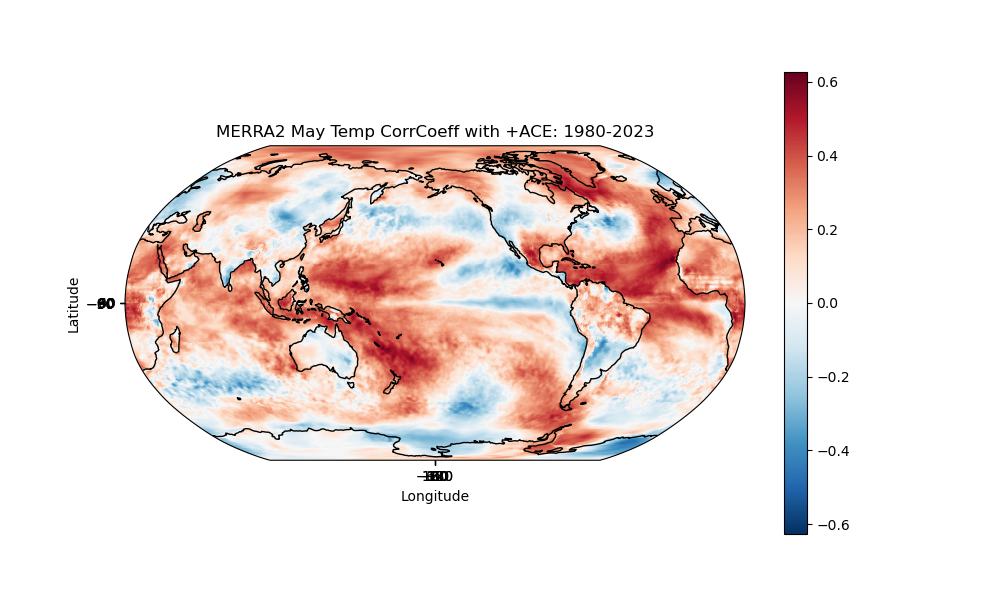
-
2025 Atlantic Hurricane Season
cardinalland replied to BarryStantonGBP's topic in Tropical Headquarters
my analysis... Factors in favor of a more intense hurricane season: - warm Caribbean and waters surrounding Florida - warm West Pacific and Maritime Continent - negative PDO - positive OHC anomalies around Caribbean and loop current Factors in favor of a less intense hurricane season: - a cool Tropical East Atlantic - some modelling showing convergence aloft over Atlantic during hurricane season Slightly above average sounds right to me. Things aren't screaming hyperactive like 2024 but the factors are slightly in favor of more storms. I'm feeling more homegrown seasons this season... not so many Cape Verde long trackers. Maybe near average ACE but slightly above average storm numbers. I'll write a storm # prediction in the thread at some point. -
Wow, only 75” here but coming down pretty good now.
-
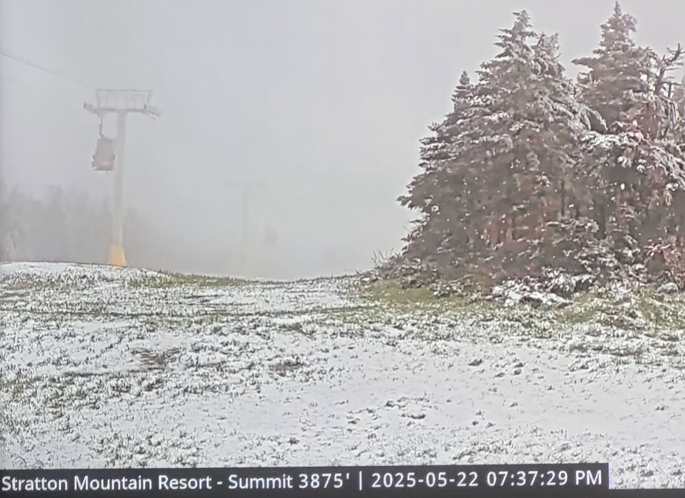
Stratton summit a bit over a week to met Summer.
-
Friggin firehose right now, holy crap man..
-
In the 40s tho
-
1.41”
-
Another observation that casts substantial doubt on the geothermal hypothesis is the cooling stratosphere. If increased geothermal activity were the cause of the warming we would expect the stratosphere to warm; maybe not at the same rate as the troposphere, but warm nonetheless.
-
we've had so-so success with the follow-up winter in a negative neutral regime. 2013-14 isnt a bad analog in terms of showing the upside. It was a -PDO follow-up winter in a neg neutral regime. But there are some equally bad downsides. It could be like a 60's winter but like the weakest years of the 60s. Who remembers 67-68? nobody
-
Caught the edge of another one. One crack of thunder and a couple minutes of rain. Pushed the total just over an inch.
-
How much you get?
-
Kind of a boring storm
-
Turned out to be a nice night
-
1.99” here so far. 40F. Nice event
-
You lucked out. A syhteton to your south and east.
-
stuck between bands here only very light rain
-
22z HRRR gone wild
-
Subsidence zone over the Merrimack River Valley… you don’t say?
-
Deck Pic the Sequel changed their profile photo
-
It’s really only happening up on the ski slopes, all infrastructure in southern Vermont is 2500’ or below. To answer the question about the low track, it’s hard to say what would have happened with a similar low and track in winter. Precip shield tends to be broader. Probably would have been a mix along the coast today. But this last band coming through likely would have been at least a few inches of snow.
-
1.52 in the stratus


.thumb.png.4150b06c63a21f61052e47a612bf1818.png)