All Activity
- Past hour
-
Good luck gentlemen! Headed to Japan next week, hope I’m talking about feet of snow while I’m skiing out there. Maybe I’ll remember to take pics for once ha!
-

First Legit Storm Potential of the Season Upon Us
SouthCoastMA replied to 40/70 Benchmark's topic in New England
Remember the storm modeled on or around 3/17/17 that was showing 12"+ for a good part of New England, then completely evaporated? I think it was withing 48-72..I know not the same idea but that was a pretty drastic change. -

First Legit Storm Potential of the Season Upon Us
weatherwiz replied to 40/70 Benchmark's topic in New England
Ahh yes...thought it was later in the season. That was a brutal, brutal bust. -
This thread being “hot” and walking into this discussion must be quite the letdown for anyone just catching up
-

First Legit Storm Potential of the Season Upon Us
EastonSN+ replied to 40/70 Benchmark's topic in New England
That was March of 2018. -

Another Coating of Snow Saturday - "It's all we Got"
DomNH replied to Sey-Mour Snow's topic in New England
Welcome to the shaft zone. -

Jan 17-18 Sunday Funday Storm
Leesville Wx Hawk replied to NorthHillsWx's topic in Southeastern States
I’m not exactly stoked about the Ensembles from what I could tell. Perhaps I’m missing something. -
Then there’s between the 2…
-
SO much chaos in the northern stream. Kick some of that out and it's almost automatically going to help modeling produce more consistently. JMO.
-
Correct, tomorrow favors us in the NW, Sunday favors your folks bay and east.
-
Maybe in retrospect a separate thread might have been better- we have 2 camps of folks in here talking past each other lol
-
Have had flurries. Keep the column ready for later.
-

Central PA Winter 25/26 Discussion and Obs
AccuChris replied to MAG5035's topic in Upstate New York/Pennsylvania
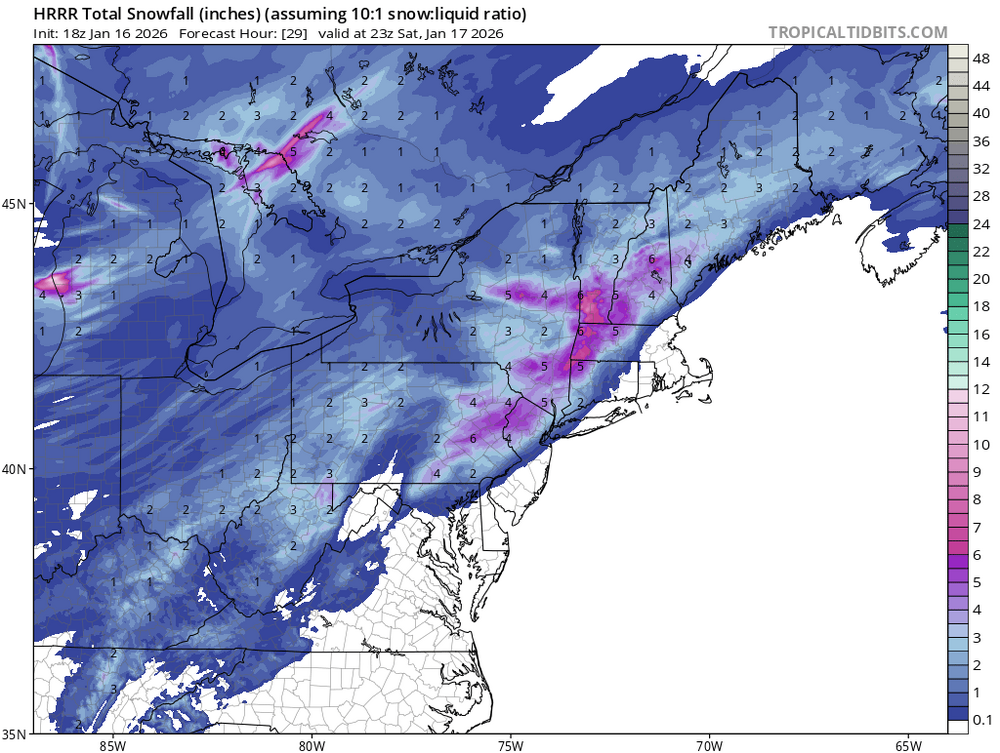
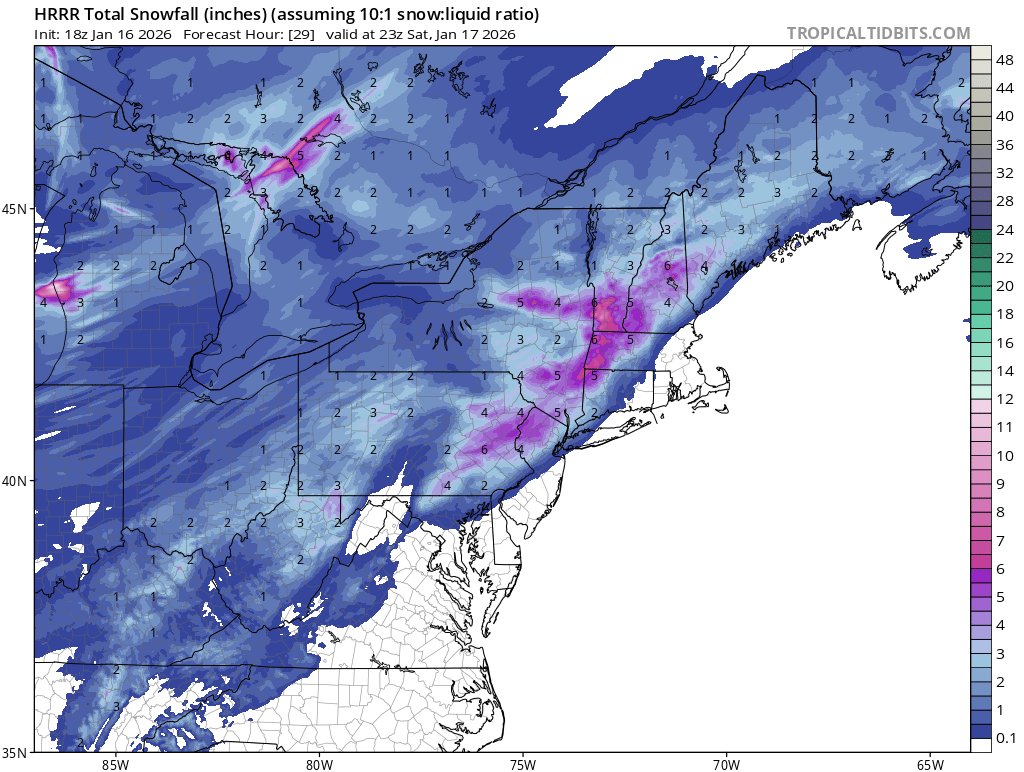
Definitely shows more on the ridge-tops versus valleys. Seems a generally 1-3” looks best with higher elevation lollipops of 4-5” possible . -
-
Its kind of amazing how quick the models snapped onto the 12z solution. Wonder how/why models went from all the variance to locking in like that.
-
First Legit Storm Potential of the Season Upon Us
weatherwiz replied to 40/70 Benchmark's topic in New England
The biggest bust I can think of (in the opposite direction) was February 2018? (don't remember the date). It looked like a good chunk of SNE was inline for like 12-18" but the confluence to the north screwed us and Long Island got smoked. Southern CT barely ended up with more than a few inches. -

Another Coating of Snow Saturday - "It's all we Got"
Damage In Tolland replied to Sey-Mour Snow's topic in New England
E MA wants the ocean storm to come west and anyone from Ray to Innedsnow to ORH down thru here and CT wants it to trend east so tomorrow drops back SE like yesterday. I know what I hope happens . Which won’t -
I can only remember one really bad Ice storm growing up. It hit in the middle of the day while I was in school. It came out of nowhere and half of us kids were stuck at school until up in the day. February 94 definitely fits that's timeline.
-
I mentioned this in my earlier post wrt the GFS- it has had this general area situated under that region-also a more impressive jet streak than the Euro.
-

Winter 2025-26 Short Range Discussion
sbnwx85 replied to SchaumburgStormer's topic in Lakes/Ohio Valley
HRRR looks particularly snow squally for many of us this evening into tonight.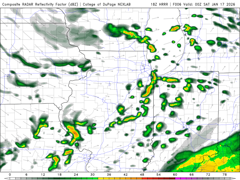
-

First Legit Storm Potential of the Season Upon Us
dendrite replied to 40/70 Benchmark's topic in New England
I’d rather compare the upper levels rather than QPF. It seems like they throw QPF further back than you would expect from the shortwave, but sometimes as you get close the shortwaves trend more amplified. So are the AIs sometimes right for the wrong reasons? -

January 2026 Short/Medium Range Thread
Weatheriscool replied to John1122's topic in Tennessee Valley
Yea, my grandparents were out for over two weeks; in their upper 80's they thought that they would never again have to cook on a wood stove, until that storm changed that thinking. I remember how everything was so heavy laden with ice, then, about 6 or so that morning it was like a front of some kind came through because the wind picked up, which is what really did the damage. To this day, this time of year, you can still pick out areas that had heavier ice because about 15' down on the trees it looks like they were all pruned back, I guess in a way they were. -

First Legit Storm Potential of the Season Upon Us
ORH_wxman replied to 40/70 Benchmark's topic in New England
We’ve had some hard west trends on scrapers before in the final 48 hours (2/5/16 is one that really stands out…1/7/17 as well)….that wouldn’t be terribly unique. But it hasn’t happened in a while. -

Winter 2025-26 Short Range Discussion
Snowstorms replied to SchaumburgStormer's topic in Lakes/Ohio Valley
Agreed. It came as a surprise to models hence why some forecasts busted too low. Mostly related to upper air interactions. This storm was purely synoptic for us. -
Another Coating of Snow Saturday - "It's all we Got"
ORH_wxman replied to Sey-Mour Snow's topic in New England
We hope so. That would probably bode very well for Sunday in SNE of Saturday trends another 75-100 miles NW (I’m not expecting that it will)


.thumb.jpg.9707d4addca3d84715ae3d888c5c10d6.jpg)