All Activity
- Past hour
-
lol…maybe Wednesday…other then that 70’s, which is fine by me.
-
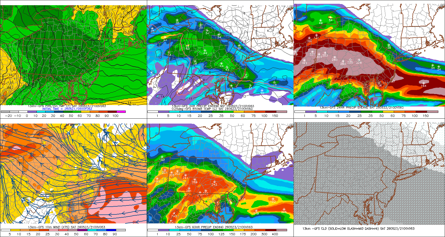
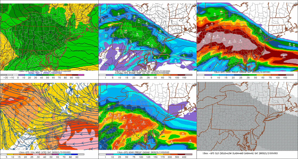
There are a few cases over the years whence something of sufficient magnitude penetrates the late spring/summer climate gauntlet enough to afflict a truly, perniciously shitty scenario. Just think back to the infamous July 4th weekend, 2020. 40s ( and I don't mean 'Kevin 40s'; real 40s), NE wind, rain. In fact, the May 1977 freak snow storm also fits into this sort of phenomenon - tho the snowing aspect might send some to feeling that's extra double special and different... Barring those few/rarer exceptions, after about ... ~ May 10th, shit outlooks tend to flop on the side of better when the days actually arrive after. I think this weekend may end up more in this ilk of inconvenience. We'll see. But I suspect Saturday is dry with some dim sun visible N of the Pike through early afternoon, then it gets more lorded over but still dry through evening. Sunday'll suck most likely... but given to the blocking that's setting up down stream, I could also see that correct a little drier as the day nears. Not sure what to make of Monday... Guidances are trying to create cold season meso lows near the Cape like it's December and trying to preserve a 31F dammed up icing scenario near FIT. No shame in this guidance about what time of year it is. Or, it's just an homage to the unusual blocking going on. That's odd btw. It's like there's a power house -NAO ridge pinning a Maritime trough in place... without having the ridge. The block appears to be non linear... like forces are just spontaneously folding up a trough over the Maritime. It's stopping us from bouncing back very warm next week, too. Not sure how much of that is real.
-
At this rate, probably. Already getting crispy here. This weekend looks like shit, but also, very little actual rain. Double whammy of suck
-

2026-2027 Strong/Super El Nino
GaWx replied to Stormchaserchuck1's topic in Weather Forecasting and Discussion
Thanks. Actually at the current point in time, I have 2026 to be most similar to 2015: check this out 13MAY2015 1.3 0.7 0.6 0.7 20MAY2015 1.3 0.5 0.5 0.8 13MAY2026 1.3 0.6 0.5 0.6 -
We sun

-
Next week is 80’s all week
-
Nice soaker this morning. Temp down to 56.
-

2026-2027 Strong/Super El Nino
snowman19 replied to Stormchaserchuck1's topic in Weather Forecasting and Discussion
-
Getting a soaking rain here the past couple of hours. Down to 57 degrees.
-
2026-2027 Strong/Super El Nino
snowman19 replied to Stormchaserchuck1's topic in Weather Forecasting and Discussion
Correct. Out of all the “recent” super El Niños (1972, 1982, 1997, 2015), *at the current point in time*, 2026 is most similar to 1997 -
Yea you’re good. Im thinking of the 4 days Fri-Monday I lose one to rain. Will lose either Sunday or Monday to rain—trending to Sunday but it’s in and out quickly. Expecting that trend to continue. On the days with sun it will be near 70. Nothing to complain about up here. It’s a shit setup though for the CT, RI, southeast MA.
-
2025 and maybe 2026 are going to go down as spectacularly mediocre in regards to this part of the country. I wish I were wrong
-
The ATL flooding was from a small cell that really only affected half the metro. Very small cell but extreme rates where it sat
-
2026-2027 Strong/Super El Nino
GaWx replied to Stormchaserchuck1's topic in Weather Forecasting and Discussion
I didn’t say 1982 was W based overall. I was specifically referring to the mid May snapshot, when it was actually W based. I said, “In mid May vs 2026”, 1982 was more W based than 2026: 1982: 1+2 was coolest in mid May 12MAY1982 -0.6 0.5 0.4 0.7 19MAY1982 -0.4 1.0 1.1 1.1 2026: 1+2 is warmest in mid May 13MAY2026 1.3 0.6 0.5 0.6 So, as of mid May, 1982 was more W based than 2026. Later (July and beyond), I agree that 1982 clearly transitioned to E based. But my post was referring only to the snapshot as of the current point in time, mid May. -
Amazing how different the UP is compared to the lower peninsula.
-
.03 yesterday, 0.33 overnight.
-
Jackpot zone so far from southern MoCo through HoCo. Around 1” for me. Couple thunder claps last night around 10-11pm were LOUD house shakers. Let’s keep it rolling today!
-
We have a dry-line-like phenomenon that is part of our spring/summer climo in New England that isn't really very well recognized. I've noticed too many times then can be counted since moving to this region of the country ...decades ago, that when it is hot and humid and a corrective cool front is approaching, we gap dry air out ahead. The synoptic mechanism for this may not be too terribly different than what happens in W Tx... in principle. We have higher elevations W, check. Wind tendency to veer S of said higher elevations. Heating E also tends to trough the structure of flow subtly, which induces W d-slope component, W of the psuedo trough axis. The result manufactures a dry line along the trough's axis... The real front is still back up stream mid NY/PA. Not exactly the same but I see similarities there. The main difference is that whence the d-line forms here, it races E. That's why we get that deep blue sky with dry cough sear heat still 88 to 91 degrees N of the Pike like we did yesterday so often in that set up. You see anvil heads on the S horizon.
-
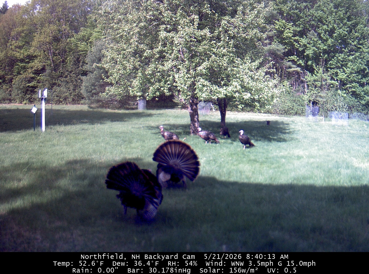
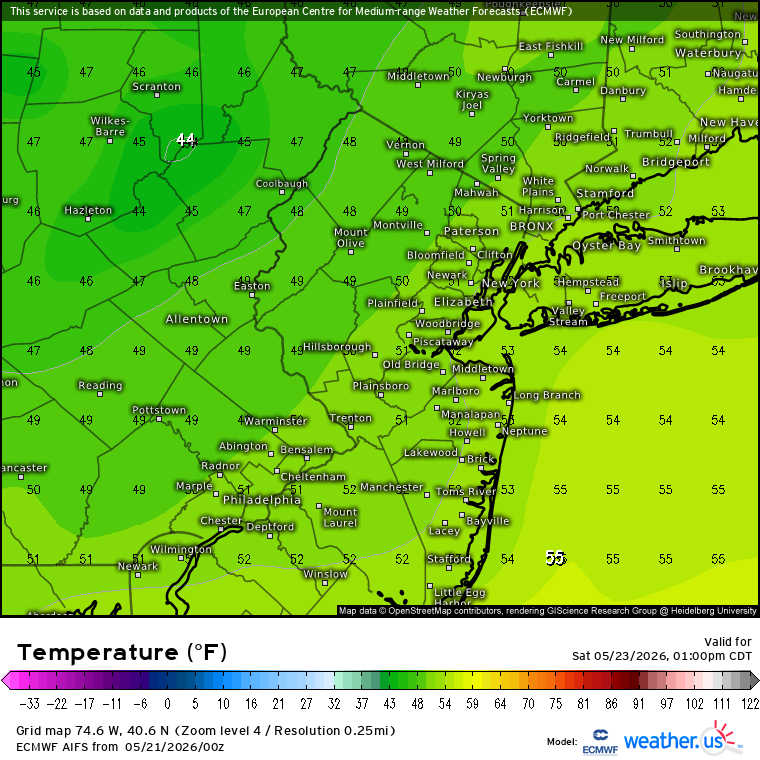
The big temperature swings pattern continues. We saw something like this with the record warmth and hard freeze earlier this spring. Now it looks like afternoon temperatures will be the upper 40s to low 50s on Saturday following the upper 90s a few days ago.

-
.03” overnight. With a 90% chance of a trace of precipitation throughout the day. AKA English spittle all day. Heading down to Wolf Trap for a concert tonight. No horrible heat but the drive down with rain will for sure be interesting. Opting to take 15.
-
Thank you! Here’s to another year of woo storms and woo sleet and woo drought with you and all the other weenies
-
Next week looks like great weather. Mid to upper 70’s and dry.
-
My inner city street and back yard at the height of the storm. As always …. IMG_1322.mov IMG_1323.mov IMG_1324.mov
-

Central PA Spring 2026 Discussion/Obs Thread
mahantango#1 replied to Voyager's topic in Upstate New York/Pennsylvania
-
Just drizzle at the moment but that's a nice slug off to my west