All Activity
- Past hour
-

Possible coastal storm centered on Feb 1 2026.
dendrite replied to Typhoon Tip's topic in New England
RGEM was still potent with the PV lobe, but was more suppressed up here in advance. -

The Jan 31 Potential: Stormtracker Failure or 'Tracker Trouncing
87storms replied to stormtracker's topic in Mid Atlantic
Biggest issue I see is the lack of a return flow out of the gulf ahead of this system. Not really sure a north trend of the ull will accomplish much aside from being a clean clipper unless we get some kind of a norlun trough involved. The best runs were mostly throwing moisture back from the Atlantic…which would be awesome but basically requires bombogenesis. -

The Jan 31 Potential: Stormtracker Failure or 'Tracker Trouncing
baltosquid replied to stormtracker's topic in Mid Atlantic
Overall the ICON-EPS moves east and looks suppressed, although there are some definite tucks in there too. Hopefully the GFS up next doesn’t nod to the Germans. -

The “I bring the mojo” Jan 30-Feb 1 potential winter storm
USCG RS replied to lilj4425's topic in Southeastern States
I mean... Blind folding a bed ridden hamster family member and asking them in English to step on what they think will happen probably has the same statistical probabilities of verifying. (I jest. Kinda). -

1/30-1/31 Lake Effect Snow Threat - SE WI, NE IL, and NW IN
homedis replied to A-L-E-K's topic in Lakes/Ohio Valley
Agree with all on this. It’s really the more disorganized lake effect/lake enhancement scenarios that we really cash in, these single intense lake effect band scenarios take a lot of luck on this side of the lake. Low expectations but high ceiling for sure. -

Possible coastal storm centered on Feb 1 2026.
dryslot replied to Typhoon Tip's topic in New England
Yeah, Good place to start, Can always adjust up if need be. -

The “I bring the mojo” Jan 30-Feb 1 potential winter storm
mstr4j replied to lilj4425's topic in Southeastern States
NAM was great with profiles on the last storm. Only one that showed us with sleet through the duration of the storm - just missed the 8 hour dry slot over the Upstate - but do we really need a model to tell us that? Kind of a given these days in the Upstate. -

Richmond Metro/Hampton Roads Area Discussion
RVASnowLover replied to RIC Airport's topic in Mid Atlantic
ICON is a big miss for everyone except extreme SEVA. Not so good trends so far in the 12z suite -
Another fun experiment is to throw a boiling cup of water into dry, frigid air. An amazing physical effect occurs. It turns into a fog of "snow," bypassing the solid state of water (ice).
-
 Matthew Cappucci is on board
 -

January 2026 regional war/obs/disco thread
tamarack replied to Baroclinic Zone's topic in New England
Hit the rad pit jackpot this morning with -23, coldest since Jan. 2022. Temp wiggled between zero and -4 last evening with a very thin cloud layer. That cloud must've disappeared before midnight, and with fresh deep snow, dry air and no wind, the temp plunged nearly 20° between 11 PM and 7 AM. -

1-30/2-1-26 Arctic Blast, ULL Snow Event
fountainguy97 replied to John1122's topic in Tennessee Valley
Yep that's how you get that second moisture push from the coastal. Great outcome. -
Yes that one, but others as well. I guess if upper air pattern is only criteria it’s using it makes some sense but the only two on the list that had the southern displacement of the PV and Arctic high deep into the south central states were Feb 1989 and Jan 1996. If you use those as criteria along with upper air patterns opens up a bunch of other events that were overall more similar. Admittedly I’m a rank amateur with little meteorological knowledge.
-

Possible coastal storm centered on Feb 1 2026.
Henry's Weather replied to Typhoon Tip's topic in New England
1-2’ easily -

The Jan 31 Potential: Stormtracker Failure or 'Tracker Trouncing
mitchnick replied to stormtracker's topic in Mid Atlantic
Helluva block -

The Jan 31 Potential: Stormtracker Failure or 'Tracker Trouncing
clskinsfan replied to stormtracker's topic in Mid Atlantic
Is that even possible with were it closed off? Seems weird to me. -

The “I bring the mojo” Jan 30-Feb 1 potential winter storm
BooneWX replied to lilj4425's topic in Southeastern States
Use the NAM for profiles, not precip output. Profiles won’t be an issue in this storm tho. -

Central PA Winter 25/26 Discussion and Obs
pasnownut replied to MAG5035's topic in Upstate New York/Pennsylvania
Here we go boys n girls. Lets hope today is better than last night. RGEM coming in a little more tucked from 6z. Not gonna extrapolate, but not gonna say i hate the look. challenge is right where it is, is where it meets "the wall". Hoping today offers a bit more clarity to the exit stage right dilemna. Might not be till tomorrow though. -
The “I bring the mojo” Jan 30-Feb 1 potential winter storm
mstr4j replied to lilj4425's topic in Southeastern States
Looks like something else perking up the interest at the end of the GFS run -
Possible coastal storm centered on Feb 1 2026.
dryslot replied to Typhoon Tip's topic in New England
Same place they should toss the model. -
Some models are kinda trending to bands of snow getting west as the low spins and rots. Better than zippo.
-

Possible coastal storm centered on Feb 1 2026.
Typhoon Tip replied to Typhoon Tip's topic in New England
It's less common as error correction now that it was back when ( grhs) he was around posting about it. The convective grid-scale feedback is less error prone in the guidance than back then. These last 20 years of guidance/technology evolution have improved on that. That's shrunk the error spectrum/causality - like we removed a lot of that specific error type when the grid scaling stuff/boundary condition was improved. Now, the error is mainly related to whether the convection triggers at all.. and in what quantity - this is still error prone but in total we don't see as many late minute adjustments. I've noticed that as these storms get closer in time, there is less escape vorticy nodes; it seems to be more of a mid range taint. -

Possible coastal storm centered on Feb 1 2026.
Kitz Craver replied to Typhoon Tip's topic in New England
And a well defined double low… not good -

The “I bring the mojo” Jan 30-Feb 1 potential winter storm
Snowncanes replied to lilj4425's topic in Southeastern States
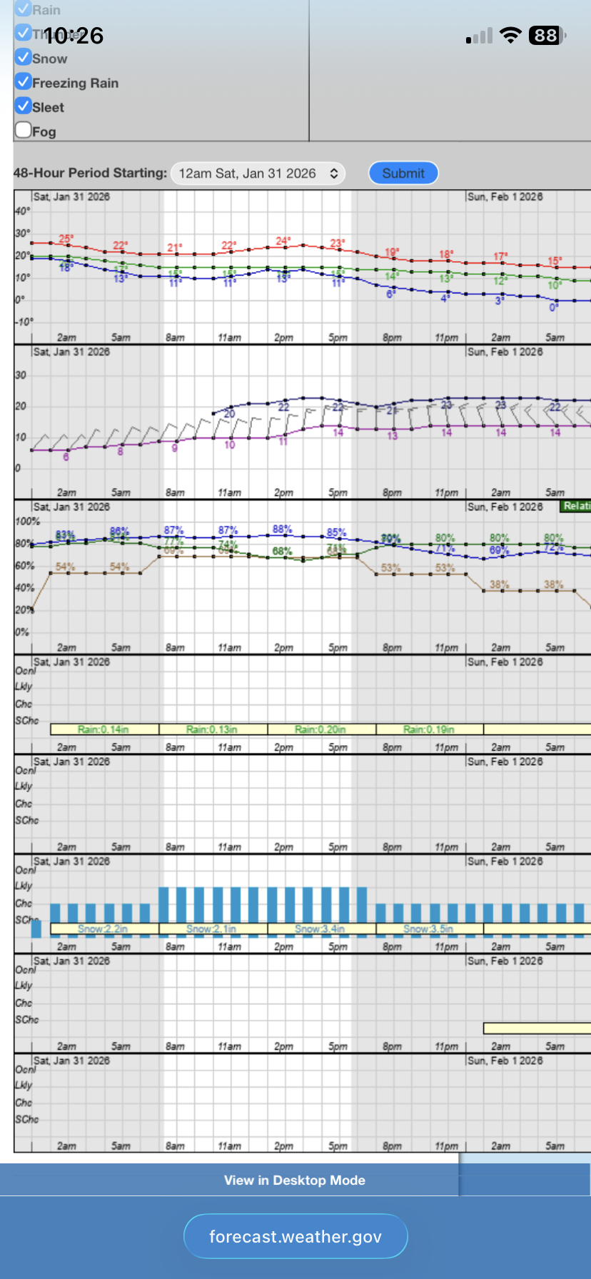
I just looked at the point forecast for RDU, and if my math isn’t failing me thats 11” and still snowing lol. Also 20mph gusts through the height of the storm. Crazy.
-

Possible coastal storm centered on Feb 1 2026.
Lava Rock replied to Typhoon Tip's topic in New England
not that it's going to happen, but a direct hit would result in how much sn? 12-18"?