All Activity
- Past hour
-
January 2026 regional war/obs/disco thread
Ocean Effect replied to Baroclinic Zone's topic in New England
GEFS better at 18z -

January 2026 regional war/obs/disco thread
ineedsnow replied to Baroclinic Zone's topic in New England
GEFS better -
And think about it - if we had no AI models at all, just the good ol gfs and euro, we’d be excited about a potential 4-8er.
-
Yeah I just edited it to say that. Yeah that's what made 2016 so fun to track
-
It's every euro model that is run, including the op, that creates the ensemble. Each colored segment is a 24 hr period of the winter goodness that specific model is showing. 50 total
-

Winter 2025-26 Medium/Long Range Discussion
Chicago Storm replied to michsnowfreak's topic in Lakes/Ohio Valley
the more i look at things, the more winter i see in the extended. -
If it ejects while we have cold air, sure. But even that’s not a guarantee in an el nino winter.
-
Whereas if we had this same Baja energy in a nino with cold air in place...we'd already be popping champagne wouldn't we?
-
Weird? Is it better to look at total snowfall mean on the GEFS or Snow Depth Mean?
-
That's what I thought. I just found it a tad amusing!!!
-
No
-
I was about to say man that rectangle was straight-up disrespectful! Hahaha And yeah that is pretty solid overall.
-

Possible Record Breaking Cold + Snow 1/23 - 1/25
Stormlover74 replied to TriPol's topic in New York City Metro
Womp womp -
GFS vs its ensembles. Normally the ensembles are much drier than the Op.
-
I am just digging back through my images archives. Here are some good ones. (BTW, the 18z GFS buries the forum over the next 16 days)..... Now you know why I like the Euro Weeklies control run. It potentially(if this storm verifies) hit the Jan 25th time frame from 30 days out - the day after Christmas! The AIFS hit it at 360. The GFS hit it earlier that the image, but its 288 map is uncanny with possibly near perfect BN heights. The EPS absolutely nailed the d10-15 over-running window - I just didn't post that image. Hopefully, this gives us some historical reference as we look back at what worked and what didn't from a LR modeling perspective. The GEPS was probably the first ensemble to really stick and hold w/ the overall look at 500.
-
It always does that - just a resolution issue for the Bay
-
Cliff diving after the drunk uncle tumbles would be hilarious. Its depiction is like my analogy of two field goal kicks colliding right in the middle from 50 yards out. It’s that hard especially in a nina winter.
-
It's clipping data on this site because of Delaware and Chesapeake bays.
-
Yes! And on mobile on pivotal “beta” there is a giant Ragu add at the bottom now I have to refresh every time lol
-
On another note, I noticed the CFS is trying to take us to a very strong Nino next winter. I wonder if it’s on to something or it’s just reactionary to what’s currently happening.
-

2025-2026 Fall/Winter Mountain Thread
ncjoaquin replied to Buckethead's topic in Southeastern States
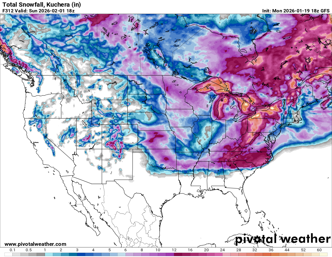
Probably won't happen this way, but the end of the month totals on the GFS are fun ( or funny) to look at. Could you imagine this?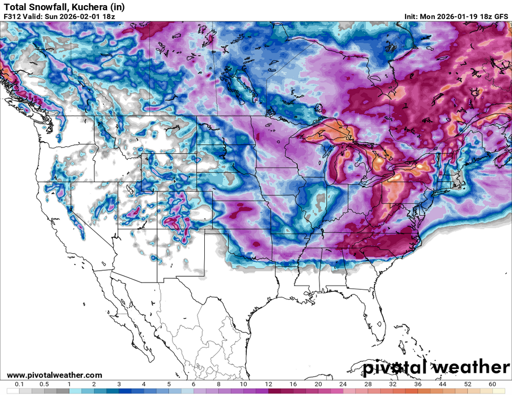
-
Well except for that weird rectangle of nothing immediately east of DC!! Looks like a resolution thing where it's not extending all the way to the coast there. And...that's snow DEPTH? Even more impressive it seems (though as cold as it should be, I imagine the snowfall isn't much different).
-
On the GFS its mostly how much interaction/phasing occurs out west- more on the 12z while 18z pretty much misses, so ends up flatter/souther downstream with the precip. (see my post a page back) The 18z GEFS is closer to 12z wrt that interaction, but a tad later.
-
Can you put this in layman terms?
-
I’m gonna go with strong to very strong