All Activity
- Past hour
-
At this point. Why even pay any attention to what the ass clown who measures in CP says. In a city of 8-9 million people, there's not 1 weather nerd like us that lives nearby that can go stick a ruler in the snow?
-
Winter 2025-26 Short Range Discussion
BeastFromTheEast replied to SchaumburgStormer's topic in Lakes/Ohio Valley
Congratz MKE …
-
Is anyone else like me?…. When you have one massive run for a snowstorm, you kinda quit looking at the mods after that? [emoji1787] .
-
I just left it alone, it was way too much of a softball even for me.
-

1/23/26-1/25/26 Winter Storm Thread
Holston_River_Rambler replied to AMZ8990's topic in Tennessee Valley
WPC extended Disco: Model guidance is in pretty good agreement on the upper level pattern through the period, especially over the central and eastern U.S. under the broad upper trough. All model guidance shows Arctic air making it down to the Gulf and East Coasts, which will clash with southern stream energy to produce a potentially high impact winter storm across the southern tier. There are some southern stream differences among the models that may affect sensible weather. The 06Z and 12Z GFS solutions were the only deterministic solutions still hanging on to a slower upper low lingering near Baja California into next week, while other guidance (including AI) has trended much more progressive with this feature. For this reason, the WPC forecast favored a faster solution with very limited influence from the GFS. A faster solution allows for increased moisture across the south-central U.S. ahead of the upper low with a broader precipitation footprint. There is still a significant amount of uncertainty in the QPF forecast this weekend. Models have been trending northwards with the heavy precipitation axis, which is in line with what the AI guidance has been showing, so adjustments were made to the NBM to reflect these trends in the WPC forecast. The WPC forecast used a blend of the ECMWF/GFS/CMC/UKMET early in the period, then increased contributions from ensemble means through the second half of the period while decreasing the influence of the GFS. -
Yea, but that only means a 6% chance of it snowing each day. I’m just kidding, @ravensrule
-
Much better, thank you good sir.
-
-
Apple Weather has like 23-27”… so that’s part of the problem.
-
1/23/26-1/25/26 Winter Storm Thread
Holston_River_Rambler replied to AMZ8990's topic in Tennessee Valley
New WPC graphic: from this site: https://www.wpc.ncep.noaa.gov/threats/threats.php -
That’s what she…actually I’m sure @ravensrulegot this one in the bag already
-
If/when the GFS shows a MECS, that's when it will really break out because I think that's what the Apple weather app uses predominately?
-

Rise of the Machines: January 18-19 Winter Storm Obs Thread
CoastalWx replied to WxWatcher007's topic in New England
I noticed the temp dropped steadily after 4p or so when the better echoes moved in. Once winds went NE and 925 started to drop that’s when it occurred. Definitely good lift in the DGZ as the flakes in the evening were great. -

E PA/NJ/DE Winter 2025-26 Obs/Discussion
Chadzachadam replied to LVblizzard's topic in Philadelphia Region
Apple weather app says next expected precip is 20” of snow Sunday lol never seen that before -
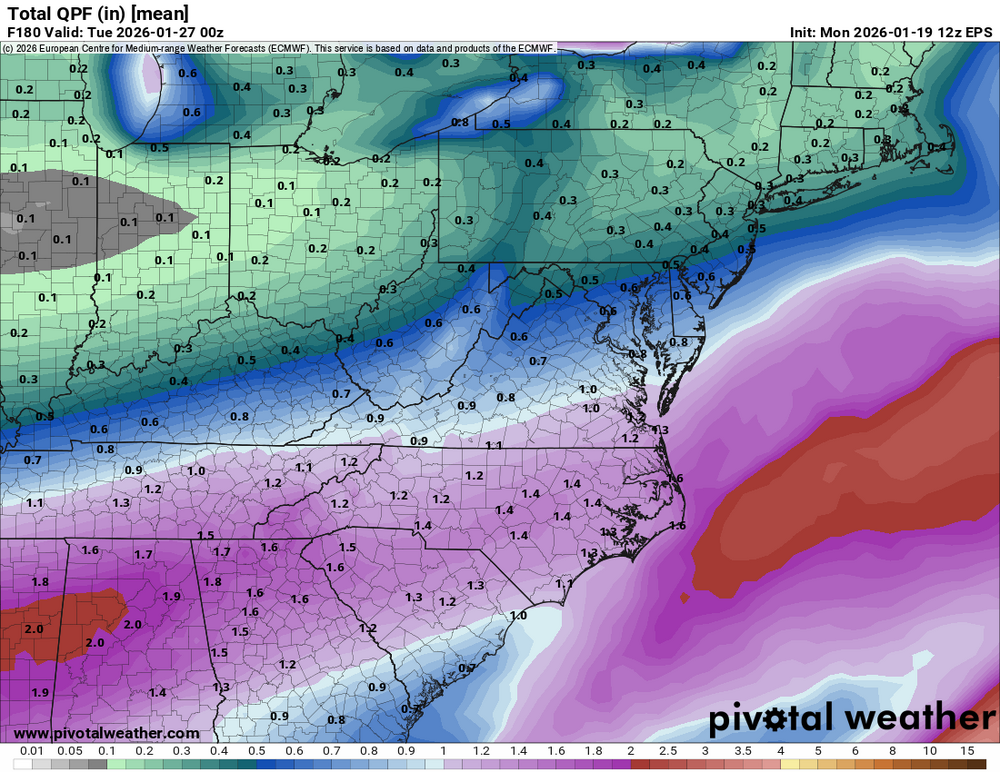
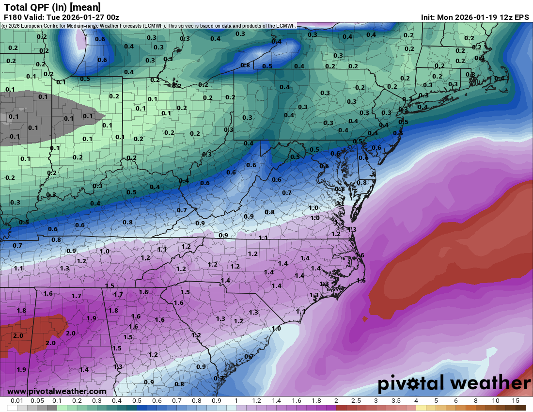
Great agreement and a ton of moisture for a smoothed mean. The heavier precip depiction back into the Lower Mississippi to Deep South is indicative of convection too. That’s another classic signature for here.
-
News of the weekend has broken containment as people are talking about it reaching below 0 with a foot of snow in convos I’ve passed by. Man the urge to correct them is strong.
-

E PA/NJ/DE Winter 2025-26 Obs/Discussion
Prairie Dog replied to LVblizzard's topic in Philadelphia Region
IF it's right, you will have a prolonged vacation Major disruption of air travel Airports will fall like domino's Good luck -
I believe the MRX forecast is heavily GFS based.
-
This arctic intrusion reminds me so much of PDII with its alignment and positioning. I can still picture the 1040 HP on the WBAL Morning news that morning of the storm drilling cold air into the area with moisture attacking. It was 12° and snowing all day. Just surreal. This has the ability to deliver something like that…a cold smoke.
-
Pretty good agreement
.thumb.png.38c5f394223252acb9edf173706a57f5.png)
-
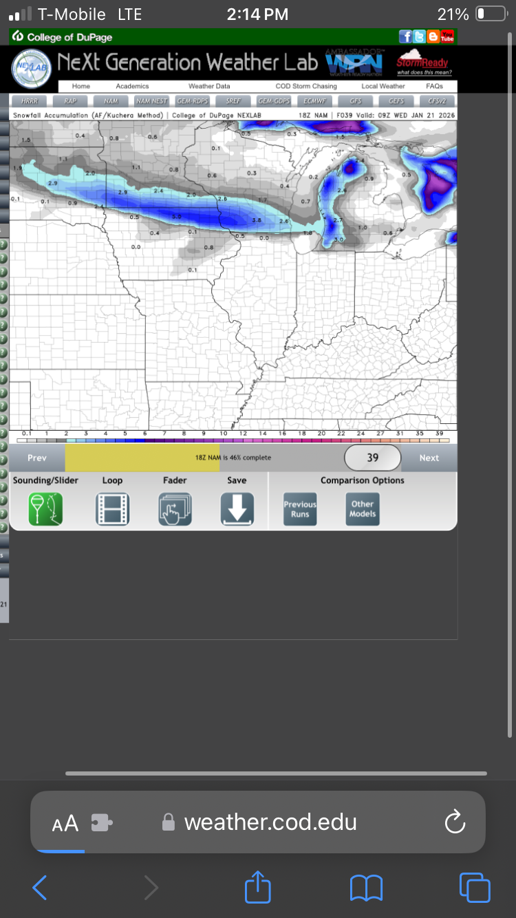
Unable to post here because I'm dumb, but 72-hr mean snowfall for NBM now has the 6" line up in southern PA. 10" line runs through DC.
-

MO/KS/AR/OK 2025-2026 Winter Discussion
JoMo replied to stormdragonwx's topic in Central/Western States
The main model difference is if the SW system comes/shears out into the Plains. Those are the bigger runs 12z CMC/Euro vs the 12z GFS which holds it back in the SW. -
We’re getting a snowstorm(s) soon and there’s nothing we can do about. Better? @ravensrule
-
If it is wound up like some of the models say it will be. Then mix is definitely on the table. Always is for our area.
-
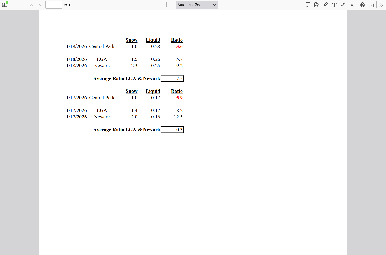
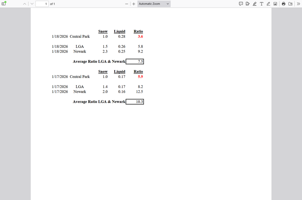
Jan 2026 Weekend Event.pdfAnd Central Park does it again. You would think that their ratios should usually fall somewhere in between Newaks and LGA since they are located in the middle. This is only two events, so a skeptic might say it's just an aberration. Let me assure the doubters it isn't. This happens much more often than it should and rarely the other way around. It all comes down to being sloppy when or how or how far after an event when they take measurements, or don't at all. This is what happens when you don't have a professional manning the ruler (it's actually a pretty simple device to work with).


.png.bcf6f52555a38a0861a2e7cee53c4b3c.png)