All Activity
- Past hour
-
https://www.spc.noaa.gov/products/md/md1049.html Mesoscale Discussion 1049 NWS Storm Prediction Center Norman OK 0540 PM CDT Fri May 30 2025 Areas affected...Northern Virginia...Washington DC...parts of central Maryland Concerning...Tornado Watch 350... Valid 302240Z - 310045Z The severe weather threat for Tornado Watch 350 continues. SUMMARY...A local corridor of greater tornado threat is evident in the DC/Baltimore region over the next 1-3 hours. DISCUSSION...A narrow zone of favorably backed surface winds, south of a warm front near the PA/MD border, will be the most favorable corridor for tornadoes over the next 1-3 hours. Local VAD data from KLWX and nearby TDWRs show sufficient SRH for low-level mesocyclone development. A bookend vortex within a linear segment in northern Virginia will continue north-northeast into this favorable zone. Farther east, additional discrete storms will also have some potential to produce a tornado. The primary limiting factors will be modest buoyancy, weak mid-level lapse rates, and limited remaining time for surface heating. ..Wendt.. 05/30/2025 ...Please see www.spc.noaa.gov for graphic product... ATTN...WFO...LWX... LAT...LON 38847850 39007821 39187785 39357727 39347659 39147634 38797648 38477706 38367775 38337838 38847850 MOST PROBABLE PEAK TORNADO INTENSITY...85-115 MPH MOST PROBABLE PEAK WIND GUST...UP TO 60 MPH MOST PROBABLE PEAK HAIL SIZE...UP TO 1.25 IN
-
Just between me and you, but I’ve always had a hard spot for whackos.
-
122 NWUS51 KLWX 302228 LSRLWX Preliminary Local Storm Report National Weather Service Baltimore MD/Washington DC 628 PM EDT Fri May 30 2025 ..TIME... ...EVENT... ...CITY LOCATION... ...LAT.LON... ..DATE... ....MAG.... ..COUNTY LOCATION..ST.. ...SOURCE.... ..REMARKS.. 0536 PM Tstm Wnd Dmg 4 W Massanutten 38.41N 78.80W 05/30/2025 Rockingham VA 911 Call Center Lots of trees reported down, especially near Rush Lane & Indian Trail Road. && Event Number LWX2505061
-
Structure collapse in Harrisonburg and numerous trees down near Massanutten 568 NWUS51 KLWX 302225 LSRLWX Preliminary Local Storm Report National Weather Service Baltimore MD/Washington DC 625 PM EDT Fri May 30 2025 ..TIME... ...EVENT... ...CITY LOCATION... ...LAT.LON... ..DATE... ....MAG.... ..COUNTY LOCATION..ST.. ...SOURCE.... ..REMARKS.. 0530 PM Tstm Wnd Dmg 2 NNE Harrisonburg 38.46N 78.86W 05/30/2025 Rockingham VA 911 Call Center A new building which was under construction was reported to have collapsed. Unsure of the size of this structure. && Event Number LWX2505060
-
Heading right for us. Need it to hold together
-
Messy radar
-
BULLETIN - EAS ACTIVATION REQUESTED Tornado Warning National Weather Service Baltimore MD/Washington DC 626 PM EDT Fri May 30 2025 The National Weather Service in Sterling Virginia has issued a * Tornado Warning for... Southern Warren County in northwestern Virginia... Northern Rappahannock County in northwestern Virginia... Northwestern Fauquier County in northern Virginia... * Until 700 PM EDT. * At 626 PM EDT, a severe thunderstorm capable of producing a tornado was located 9 miles north of Sperryville, or 9 miles south of Front Royal, moving east at 40 mph. HAZARD...Tornado. SOURCE...Radar indicated rotation. IMPACT...For those in the direct path of a tornado touchdown, flying debris will be dangerous to those caught without shelter. Damage to roofs, siding, and windows may occur. Mobile homes may be damaged or destroyed. Tree damage is likely. * This dangerous storm will be near... Linden and Hume around 635 PM EDT. Delaplane around 645 PM EDT. Other locations impacted by this tornadic thunderstorm include Huntly, Arco, Marshall, Flint Hill, Fourway, Cresthill, Rectortown, Glen Echo, Meadowville, and Markham. PRECAUTIONARY/PREPAREDNESS ACTIONS... TAKE COVER NOW! Move to a basement or an interior room on the lowest floor of a sturdy building. Avoid windows. If you are outdoors, in a mobile home, or in a vehicle, move to the closest substantial shelter and protect yourself from flying debris
-
How could you talk about your girlfriend like this?.
-
One BIG very important thing is to make sure that its not the battery keeping it from closing. Older Lithium Ion laptop battery's can swell up and possibly catch fire, especially if they are plugged into AC power for long periods at a time. Pull it out look and feel up and down it, you'll be able to tell. If its swollen get it out of there. You can get refurbished ones for most laptops on Ebay for 20 bucks or less. I've got one like that (am actually typing this on it, kinda). If it's like mine (and not the battery) it's probably got a couple three broken tabs that hold the clam shell together. No easy fix (that I know of) unless you feel comfortable removing the guts and putting them in an identical (if you can find one) clam shell off of Ebay. It's a common "break" on older laptops and isn't a big deal unless you are still very mobile with it. Or you could do what I've done with mine. Mine is the original version of the Intel Core I5 (late '08) and it does the same thing as yours, on 2 sides lol. Hell, half the keys on the keyboard are gone and the screens broken lol. I just put a piece of duct tape (with a small slit to enhance cooling on the old bird) on it to secure it where it pops open. . Mine is plugged via HDMI into my TV with a bluetooth keyboard and mouse on the coffee table. It was my work PC for 10 years. It's been through hell and back including sliding off the top of my car while getting on I95 just N of Savanah GA because I forgot to put it into my bag lol. Scratched up but still fired right up. Still works like a champ to this day even though it's in nearly 16 years old. Takes most anything I throw at it, in it or on it lol (except gaming stuff of course). I'll use it until it smokes. One of the best 2k bucks I ever spent. Old Acer's where rock solid laptops.
-
Not sure about this, but I just got an alert for a tornado watch in the metros. It was from Alexa and she’s a whacko so I’m not sure.
-
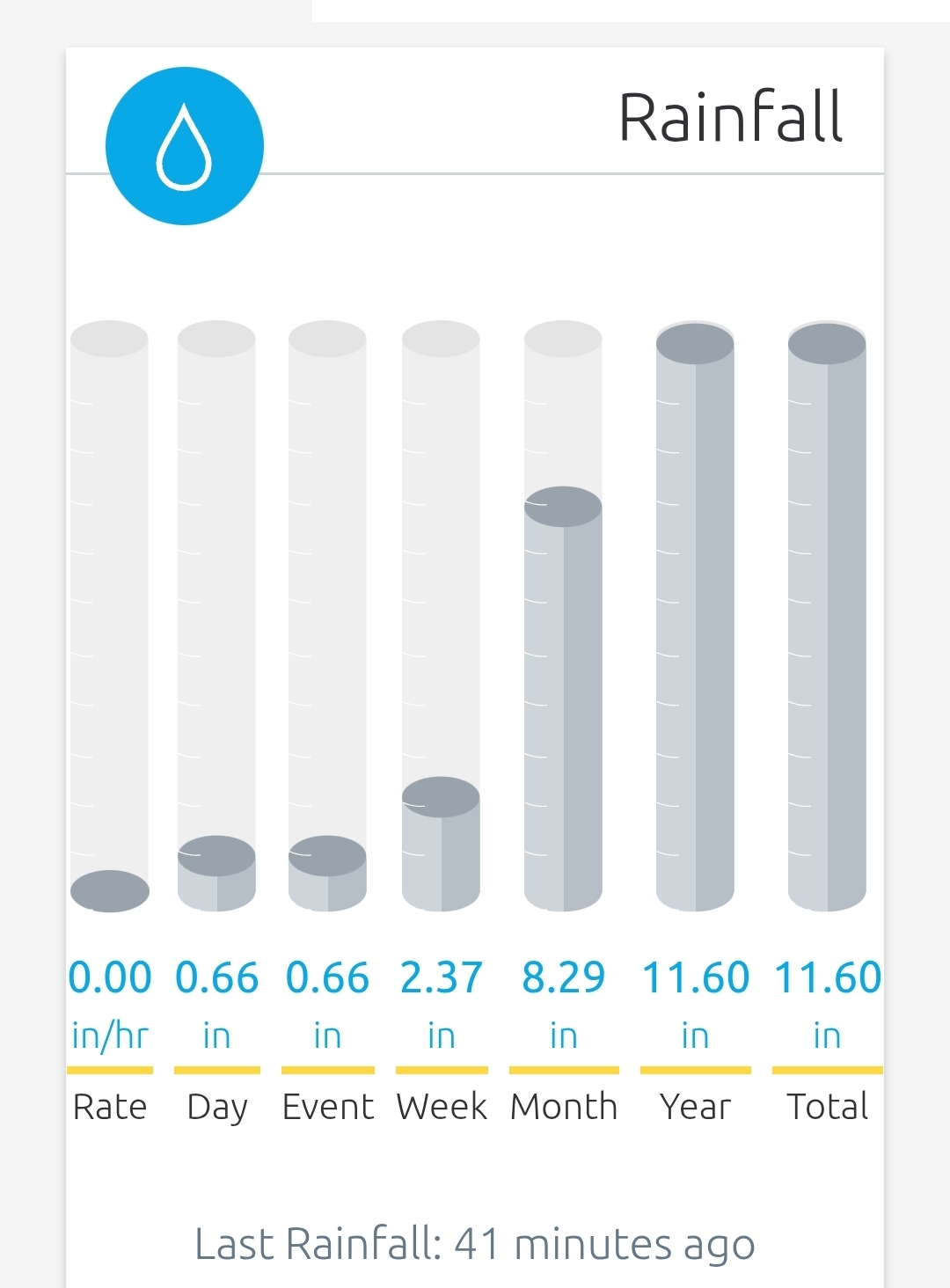
Seems like a real chance at a 9" month if this next batch is solid
-

E PA/NJ/DE Spring 2025 Obs/Discussion
Hurricane Agnes replied to PhiEaglesfan712's topic in Philadelphia Region
Tornado Watch for the area - -
Showers with some downpours here the past two hours. Now the good stuff is headed this way.
-
Euro/GGEM bang 6/6.
-
12z still shows that
-
Man that hook looks to be heading my way...yikes
-
Very dark to my south west…constant rumbling…
-
Looking at the radar, feels like a winter storm, watching the heavy returns creep NE. Your not wrong. Sunday looks nice, then we should get a taste of summer.
-

2025 Spring/Summer Mountain Thread
Met1985 replied to Maggie Valley Steve's topic in Southeastern States
Heavy rain and storms moving through again this evening. Temps have dropped from mid 60s to mid 50s now. -
-
- 848 replies
-
- 1
-

-
- severe
- thunderstorms
- (and 2 more)
-
That line should be in DC metro around 8pm... Tornado warned portion is on path for the metro
- 848 replies
-
- 1
-

-
- severe
- thunderstorms
- (and 2 more)
-
Maybe bonus Canadian wildfire smoke?
-
Just what hippie wants more rain.
-
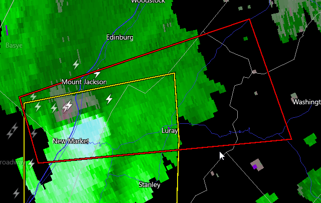
BULLETIN - EAS ACTIVATION REQUESTED Tornado Warning National Weather Service Baltimore MD/Washington DC 550 PM EDT Fri May 30 2025 The National Weather Service in Sterling Virginia has issued a * Tornado Warning for... Southern Shenandoah County in northwestern Virginia... Central Rockingham County in western Virginia... Southwestern Warren County in northwestern Virginia... Northern Page County in northwestern Virginia... West central Rappahannock County in northwestern Virginia... * Until 630 PM EDT. * At 549 PM EDT, a severe thunderstorm capable of producing a tornado was located near Mount Jackson, or 16 miles southwest of Woodstock, moving east at 40 mph. HAZARD...Tornado. SOURCE...Radar indicated rotation. IMPACT...For those in the direct path of a tornado touchdown, flying debris will be dangerous to those caught without shelter. Damage to roofs, siding, and windows may occur. Mobile homes may be damaged or destroyed. Tree damage is likely. * This dangerous storm will be near... Luray and Mount Jackson around 555 PM EDT. Sperryville around 615 PM EDT. Other locations impacted by this tornadic thunderstorm include Kimball, Kings Crossing, Compton, Shenandoah Caverns, Leaksville, Hamburg, Fourway, Quicksburg, Fairview, and Bentonville. PRECAUTIONARY/PREPAREDNESS ACTIONS... TAKE COVER NOW! Move to a basement or an interior room on the lowest floor of a sturdy building. Avoid windows. If you are outdoors, in a mobile home, or in a vehicle, move to the closest substantial shelter and protect yourself from flying debris. && LAT...LON 3861 7874 3872 7878 3885 7829 3865 7820 TIME...MOT...LOC 2149Z 256DEG 36KT 3867 7867 TORNADO...RADAR INDICATED MAX HAIL SIZE...<.75 IN