All Activity
- Past hour
-

January 2026 regional war/obs/disco thread
wxeyeNH replied to Baroclinic Zone's topic in New England
I think since living up here I have only had a couple of days where I stayed below 0F all day. Just below, nothing like 1933. My record low is -19.5F with that brief brutal arctic blast a few years ago. -
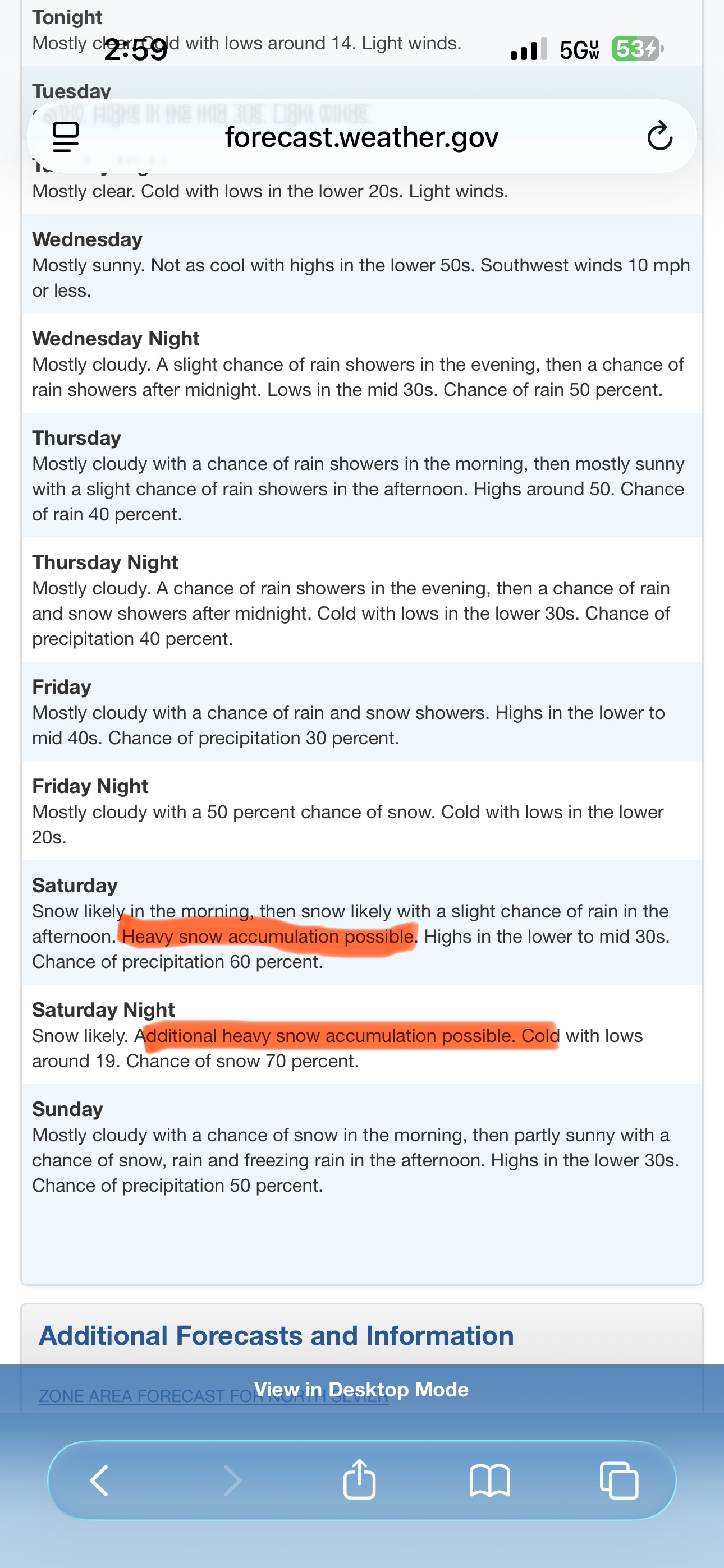
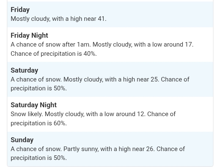
"Snow likely" 5 days out is rare.
-
Showtime
-
Yes, Mr. Bob should have it pinned soon. He usually does it pretty quickly after a thread goes up.
-
Is he wishcasting?
-

MO/KS/AR/OK 2025-2026 Winter Discussion
StormChazer replied to stormdragonwx's topic in Central/Western States
-
-

Storm potential January 17th-18th
NorthShoreWx replied to WeatherGeek2025's topic in New York City Metro
Melted water equivalent for the weekend here was 0.50". Includes the 0.3" snow on Saturday and the 2.6" on Sunday. Roughly 6:1 ratio across both events. -
Very informative Ty
-
real loser shit imo
-
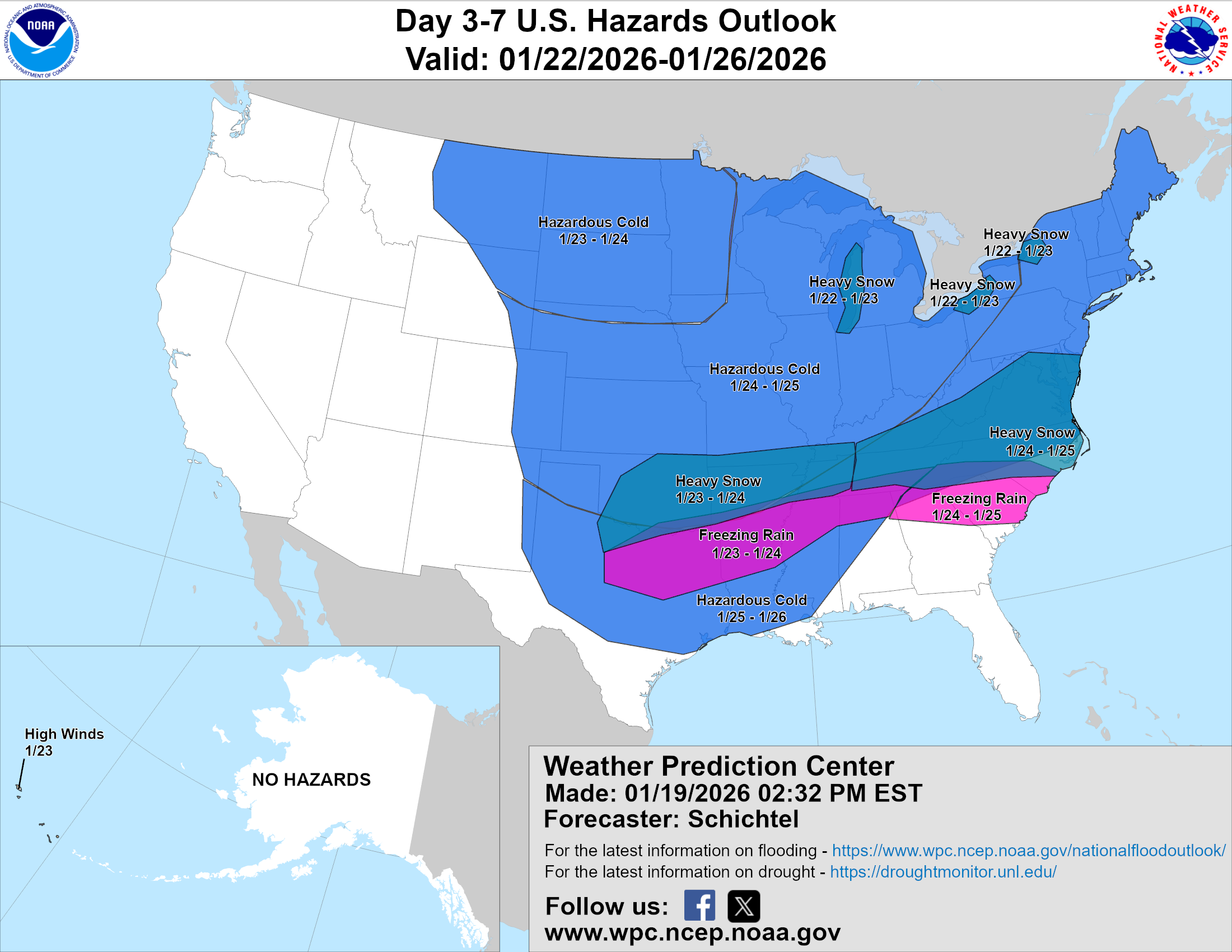
Zone area forecast for Seymour from MRX. Hang it on the wall.
-
Yes 12z Thursday is my go/no suite for this event.
-
Yes! 12Z has northern MD dropping below 20 degrees Friday afternoon and not getting above 20 degrees until sometime the following Wednesday which is over 120 hours. We've had many strong shots of cold but many times they're in and out and rarely sustained. This appears to be different.
-
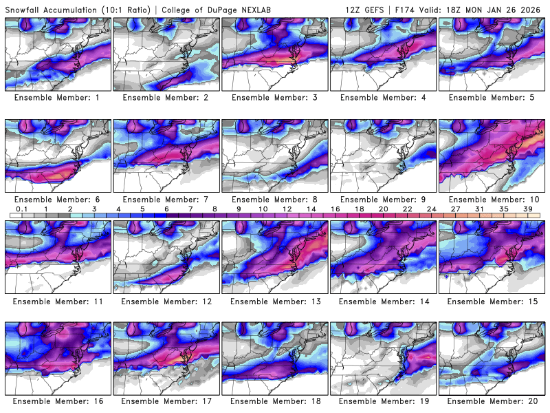
My 7 model blend for Augusta has increased from 6.5" at 7 am to 11.4" at 3 pm. I have to admire the GFS for sticking to it's guns with suppression from strong arctic hp., but the tide seems to be going out........................... I am reminding myself that this is still 5 days away........................... Honestly, I will be very happy with 6 - 8 inches....................
-
.
-
Yes agree rain is not even really a possibility in this setup with a high like that. If the low somehow hugged the coast worst case scenario is sleet but most likely its either heavy snow, light snow on the fringe, or nothing.
-
Gefs is based on gfs which was a dud so not shocking most its ens aren’t great.
-

Storm potential January 17th-18th
Kaner587 replied to WeatherGeek2025's topic in New York City Metro
North shore of Nassau cty microclimate ftw. Difference between lie south and northern blvd north is extremely impressive. Probably just a small diff in temps can account for this -
I know everyone is excited about the possibility of a storm this weekend but the Euro is showing a very stable cold pattern the next 10 days as well.
-

Central PA Winter 25/26 Discussion and Obs
Jns2183 replied to MAG5035's topic in Upstate New York/Pennsylvania
At day 5 compared to day about 60-70% of the low mean pressure has come north with a mean distance of 100 miles Sent from my SM-S731U using Tapatalk -
Weather channel has me back at 1 to 3 for Friday night 5 to 8 for Saturday and 3 to 5 for Saturday night. Been a decade or more since I have seen that much in middle TN
-
At least until we get convergence on the individual members. This is still a substantial spread on the GFS. Still ~8 of 20 members that are duds for most of us.
-

January 2026 regional war/obs/disco thread
dendrite replied to Baroclinic Zone's topic in New England
A high of -11° at CON…they’ve done a sub zero high once since the Feb 1943 shot (-2 1981). But yeah…everything had to align for that 1933 airmass. -
Dude. She will have other birthdays, including one next year. She's not even your wife. Stay home and enjoy what could be historic. Tell her flights canceled it's out of your control and send regards.
-
A 1053 mb Arctic high to the north absolutely guarantees cold and it does press the baroclinic zone south, but it does not automatically choke off coastal systems. In fact, highs of that magnitude often enhance the setup by sharpening the thermal gradient and strengthening the coastal front. Suppression becomes a real concern when the high is not only strong but also poorly positioned, centered too far west with confluent flow flattening the downstream wave. That is not what this pattern suggests. Here, the high acts more like an anchor than a lid. Cold air is locked in, the storm track is displaced south and east, and lows tend to ride the boundary offshore rather than cut inland. That favors snow and keeps systems close enough to matter. You can still miss if a wave stays too far offshore, but that is a track issue, not classic suppression. With a high this strong, the outcome is not rain or nothing. It is snow or a near miss, and NYC sitting near the gradient is exactly where small adjustments can pay off.