All Activity
- Past hour
-

January 2026 regional war/obs/disco thread
Kitz Craver replied to Baroclinic Zone's topic in New England
I’m so confused -
January 2026 regional war/obs/disco thread
Patfan1987 replied to Baroclinic Zone's topic in New England
Some issue I am taking with Tapatalk …. -

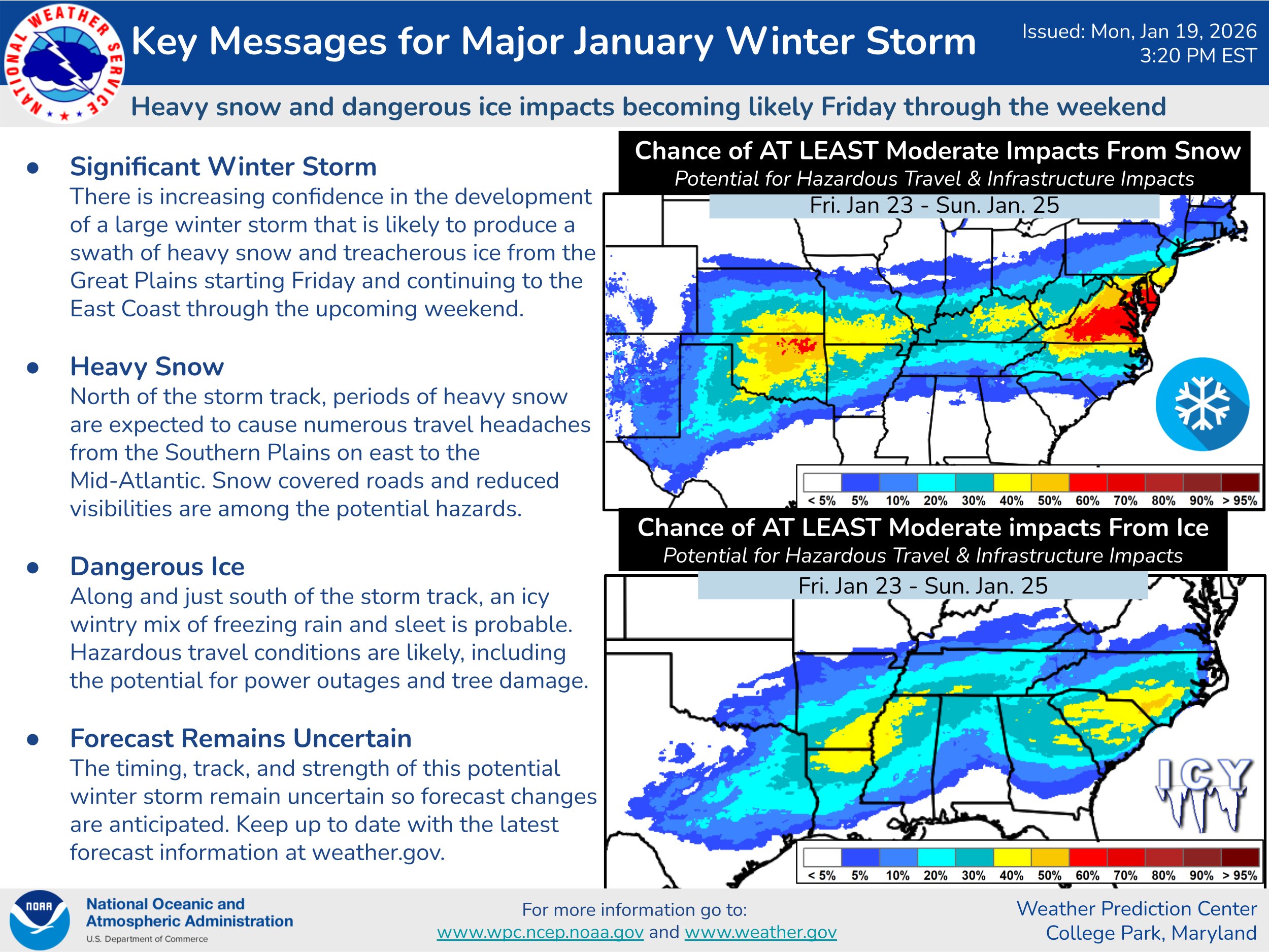
Possible Record Breaking Cold + Snow 1/23 - 1/25
North and West replied to TriPol's topic in New York City Metro
I didn't want to, but I feel like, again, it's going to be more than four hours. -

January 2026 regional war/obs/disco thread
WinterWolf replied to Baroclinic Zone's topic in New England
What? -
Thank you for the mention. I do appreciate you touching base throughout the years. Like that you enjoy cooking as much as I do. What a nice thread. I must say I have been a bit distant over the last year. Had a bit of unexpected stuff go on that I struggled getting through. I know I am not the best at weather and most times feel like a fish out of water. But weather is one of those obsessive likes that my brain has decided to follow. Will say a shout out to @Eskimo Joe when it comes to anything horses. Thanks for understanding one of my other obsessive likes which I try to keep at bay here.
-
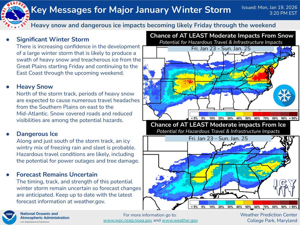
GSP 4:00pm A low pressure system will move near the area this weekend. Temperatures will be cold enough for wintry precipitation for much of the area. Details remain uncertain, but there is the potential for significant wintry weather. Stay up to date with the latest forecasts as the details evolve.
-
Won’t matter we’d know the result by then.
-
I’m hopeful but still cautious. The confidence some very good Mets have at the chance for the low track to still be as high as TN/KY worries me. We really need a missed phase and weaker strung out system to fight that. Who woulda thought we’d be cheering for that after these last few years lol?
-

January 2026 regional war/obs/disco thread
weathafella replied to Baroclinic Zone's topic in New England
That was a futile scroll…. -
I asked in the other thread and got crickets - maybe it was posted in the wrong thread. Long time lurker, and I just have a simple question. GSP area bias (no snow since God knows when). Is the issue with the track based on the location of the high? The high seems rather powerful, I think it was depicted anywhere between a 1040-1058 so cold dry air shouldnt be an issue. But does the placement of the high (and it literally looks like a 30-50 mile difference) create enough WAA to give sleet and freezing rain vs freezing rain with a powerful high Iike that, which shouldn't budge? If im not mistaken the last few years the issue was too cold and we had suppression city with New Orleans getting almost a foot, and Myrtle Beach picking up 6 inches. Most of the snows in this area are CAD events right? Rain cools down column with low dew points, then sleet, before it turns into snow and you hope all your qpf wasn't used in the transition. I am just curious what makes this setup different. - thanks in advance!
-
Not based on anything scientific, but Chattanooga has been severely overdue for an ice storm for many years. I do not get an overly snowy feeling with this one. I'm servicing my generator today.
-
My wife encourages boys trips to Vegas, she just asks me not to come back.
-
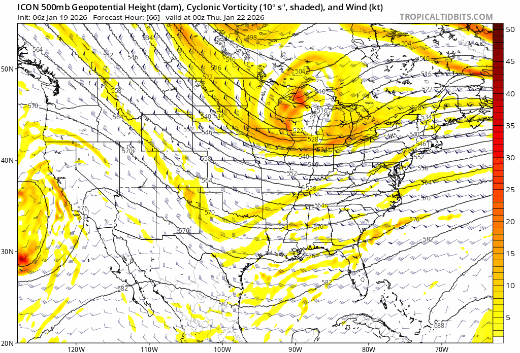
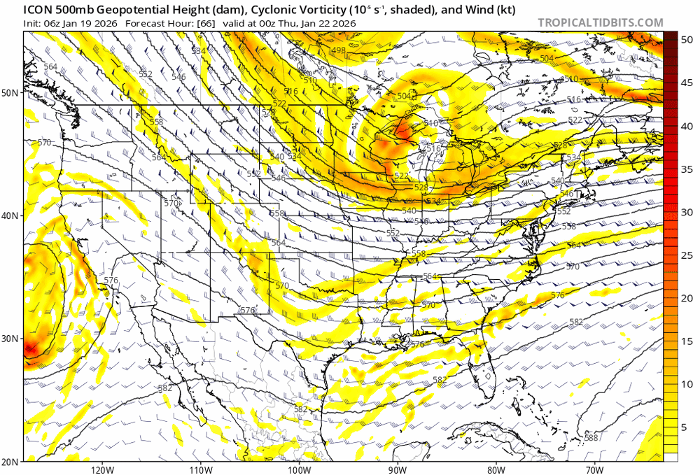
Just a reminder, both 06z and 18z ICON only go out to 120
-

Possible Record Breaking Cold + Snow 1/23 - 1/25
Nibor replied to TriPol's topic in New York City Metro
Tomer is always a good read: -
Icon coming out and SW is NE so far comparing the runs.
-

January 2026 regional war/obs/disco thread
HoarfrostHubb replied to Baroclinic Zone's topic in New England
What the heck was that? -
-
@Ralph Wiggum mentioned in the other sub that across all guidance the high weakened slightly from thr 1050s to 1044 at the most
-
Very generally speaking, thunder snow is reserved for storms that deepen rapidly near your latitude (bomb out) or less commonly a vigorous closed upper level low pass creating instability and pockets of big lift. I don't really see either with this event yet so my guess is no. There's a big thermal gradient but otherwise not a bomb scenario or gnarly closed upper level low.
-
https://x.com/i/status/2013350503464227182
-

E PA/NJ/DE Winter 2025-26 Obs/Discussion
Maestrobjwa replied to LVblizzard's topic in Philadelphia Region
I think that'll be good for both our subs...because a weakee high would lessen suppression risk, right? -
Can’t say I hate being on the north side of the heaviest snows as depicted by the nbm. Still a little worried about suppression, but 12z assuaged that concern just a little bit.
-
yeah after the second storm, we had like 4' of snow on the ground in Philly. Unreal.
-
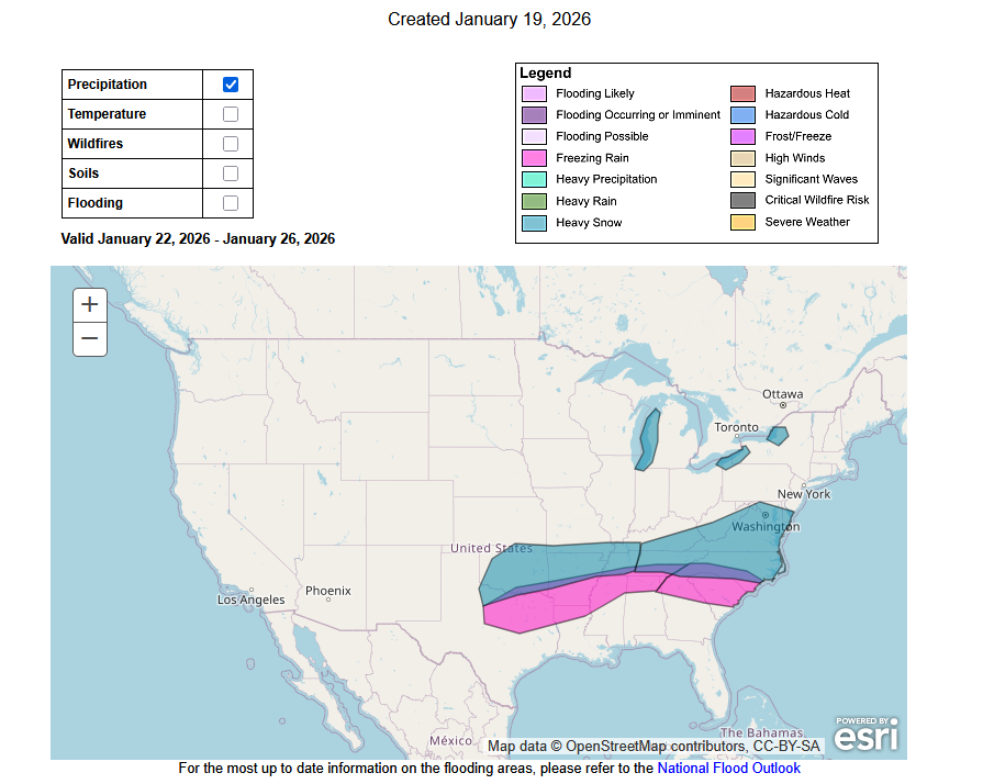
Cold. Here's the precipitation:
-
So my big question is, who has the plow to pick up me and the surgical team so this doesn’t get cancelled lol .