All Activity
- Past hour
-
Inch on the nose today. 1.72” for the event.
-
.55 + call from early morning looking solid . You’ll end up near or over .75. Lesson to you never, ever to partner with TFlizz and his sister wives
-
Nice steady light rain or sheet drizzle all day here and it's only 0.36"
-
Yes. It is consistent with a rapidly strengthening El Niño. New weekly numbers come out tomorrow.
-
Yeah, about half inch. Just a little under. Stuff developed. That should be about it except for isolated downpours tonight.
-
Radar is juiced down there too in SE MA. From SE CT right thru TAN up to S Wey . Nice rain train tonight .
-

2026-2027 Strong/Super El Nino
MarcmmKU replied to Stormchaserchuck1's topic in Weather Forecasting and Discussion
Totally agree. I'm an avid skier and strong ninos make my gut sink. I am praying we don't see a repeat of 2015-2016 in Vermont. Would be a disaster. -
From Raleigh east to Greenville has been the looser so far. Only 0.21" for me so far. Hoping I can cash in Tomorrow.
-
Feels like the hand wringing gets worse now with rain compared to snow. We are all getting old haha.
-

Central PA Spring 2026 Discussion/Obs Thread
Blizzard of 93 replied to Voyager's topic in Upstate New York/Pennsylvania
Welcome Home! I hope the rest of your trip was great! -
Central PA Spring 2026 Discussion/Obs Thread
Blizzard of 93 replied to Voyager's topic in Upstate New York/Pennsylvania
Mist has returned to Marysville this evening out ahead of the next line of showers approaching for later this evening. -
Miss south unless one of the cells can hold it together after sunset. Sky looks great though
-

2026-2027 Strong/Super El Nino
michsnowfreak replied to Stormchaserchuck1's topic in Weather Forecasting and Discussion
Same here in the Great Lakes- strong ninos usually are bad news. But its all relative. Winters in the Lakes and interior northeast are much harsher than the coast. So winter is more often characterized as a whole versus the coast where one huge storm (or lackthereof) often makes or breaks the winter. So basically, I already know im going to have winter, its just highly likely I'll get less of it than usual. Whereas those along coast from NYC south to the midatlantic wont be surprised in April 2027 if they've just seen a 5" winter with no storms or a 35" winter thanks to a massive storm. -
Getting foggy outside quickly this evening.
-
Picked up another 1" exactly today. This puts me at 4.14" for the month.
- Yesterday
-
Didn’t matter, everything evaporated heading into central NC again
-
As of 8 PM Taunton .66 S Wey .54 WTTTE
-
2026-2027 Strong/Super El Nino
MarcmmKU replied to Stormchaserchuck1's topic in Weather Forecasting and Discussion
For the interior northeast strong nino is almost always bad news. Coast can get a good fraction of their seasonal totals from 1 KU type storm, which are more likely to occur in traditional niños. -
2026-2027 Strong/Super El Nino
MarcmmKU replied to Stormchaserchuck1's topic in Weather Forecasting and Discussion
Very hard to escape -pna now. Was kinda a miracle this last winter was better in that regard. -

2026-2027 Strong/Super El Nino
mitchnick replied to Stormchaserchuck1's topic in Weather Forecasting and Discussion
Looks like the Euro failed on this warm forecast. -
2.16 inches here and more to come tomorrow morning.
-

Mid-Long Range Discussion 2026
WinstonSalemArlington replied to BooneWX's topic in Southeastern States
-

2026 Spring/Summer Mountain Thread
Maggie Valley Steve replied to Buckethead's topic in Southeastern States
Just updated...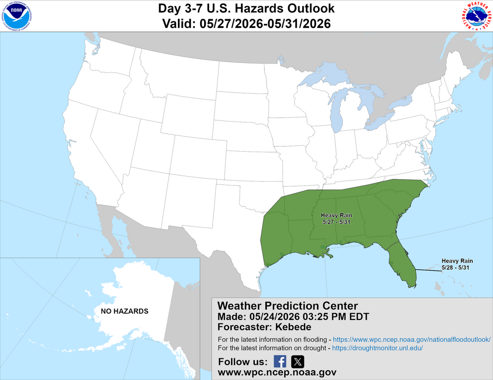
-
HRRR and GFS try to paint that as well.
-
below normal days for the late spring and early summer actually make me happy like 72 and sunny! not rain and 50 degrees