All Activity
- Past hour
-
If you confused, you are not alone. While I understand what SPC is trying to do here (quantify risk better), it not easy or always intuitive (probabilities and statistics are are tough subject for many, or kind of dry)! If mets and wx enthusiasts have problems figuring this out this, forget it as to the general public! It somewhat reminds me of interpreting the homograph, it not intuitive at first you have to spend time on what you are looking at and think in 3-D despite looking at a 2-D plot!
-
Lol RADAR OUTAGE: The National Weather Service says its KDIX radar is currently down for an unknown reason. Technicians have been notified, but there is no estimated return-to-service time. You can still monitor the NWS national radar mosaic, which incorporates surrounding radars, but local low-level coverage may be less precise. Keep Wireless Emergency Alerts enabled, follow NWS Mount Holly and trusted local media, and use a reliable weather app for warnings. We’ll continue monitoring updates and public reports here.
-
Richmond has some impressive numbers at the airport. Wonder what will go into the report.
-
Glad I got that storm with the warm front this morning. Seeing the usual gap on the radar.
-
Good to know. Thanks!
- 1,138 replies
-
- 1
-

-
- severe
- thunderstorms
- (and 7 more)
-
large tree branches down, numerous intermittent power failures, 10 minute power outage. strong winds. from untrained eye appeared as if may been a microburst. house creaking. local lightning strikes. 21122.
-

Saturday, July 18, 2026 Thunderstorm/Severe Weather Potential
weatherwiz replied to weatherwiz's topic in New England
I would wager by 5:00 we probably see an MCD for western areas. -
Punxatawney Phil needs to get to his basement or sturdy room. Oh, he's a groundhog? Already in his den, underground.
-

Central PA Summer 2026 Discussion/Obs Thread
Voyager replied to Voyager's topic in Upstate New York/Pennsylvania
I don't know what happened. The rain seemed to train over the area. One concern I have is that I looked at the USGS Tamaqua gauge and it showed a bit less than my backyard. It shows 1.25". I wonder how accurate the hepatic rain gauge on the Tempest is. More and more, I've been contemplating going back to a traditional weather station with a tipping bucket and wind cups. -

2026-2027 Super El Nino
LakePaste25 replied to Stormchaserchuck1's topic in Weather Forecasting and Discussion
Important to note that this El Niño event will remove a lot of heat from the oceans (and into the atmosphere) if it materializes as record-breaking. This is one of the reasons why El Nino doesn’t preclude a strong La Niña, and ENSO itself acts more like a damped nonlinear recharge oscillator. -

E PA/NJ/DE Summer 2026 Obs/Discussion
enpawx_observer replied to PhiEaglesfan712's topic in Philadelphia Region
They just showed a drone shot on the Phillies broadcast and it's pretty heavy. Not as bad as Thursday but still super noticeable -
Latest HRRR has the South Jersey Alley area keep getting hit and whatever storms coming from UNY fizzling as they get here.
-

2026-2027 Super El Nino
Stormchaserchuck1 replied to Stormchaserchuck1's topic in Weather Forecasting and Discussion
I never mentioned climate models. I'm just saying the logic is areas further north and over the arctic are +2-3std greater than the tropics and mid-latitudes. So when a 11-year anomaly is centered so far south, and with much greater anomaly than the north, that's because something big is going on. A specific meteorological pattern. These jumps to you are like "points" or "thresholds" but I don't think it works like that. Maybe a small part, but there was a string in 1976-1983 with 4 El Nino's, 3 Neutral, and 0 La Nina's and that was followed by one of the most +PNA times decadally on record. Super El Nino's are not expanding the Pacific Hadley Cell to such an extent imo. Actually the most basic argument is that Super Nino-driven global max temp rises should be melting Arctic ice to a greater extent, and the opposite has happened since 2013. Imo, that's a big reason for the -PNA patterns, constant low pressure over the Arctic circle in the warm season. I agree that it will be interesting to see where we go from here. But I don't expect the main cause to be a northern and southern Hemisphere Hadley Cell expansion much greater than all other regions of the globe. -
Saturday, July 18, 2026 Thunderstorm/Severe Weather Potential
weatherwiz replied to weatherwiz's topic in New England
That stuff west of BGM starting to look pretty good with cooling cloud tops. Looks like it just behind the warm front too. Probably up to the CT River probably still in game for svr potential given it looks like the warm front should get there. Want to see dews get to around 72-73...not sure how far northeast those will make it though -

E PA/NJ/DE Summer 2026 Obs/Discussion
BBasile replied to PhiEaglesfan712's topic in Philadelphia Region
Still 89F with a 79F dew here. Plenty of juice. -

2026 Mid-Atlantic Severe Storm General Discussion
SnowenOutThere replied to Kmlwx's topic in Mid Atlantic
Looks like I can check off getting inside the notch of a supercell from the bucket list.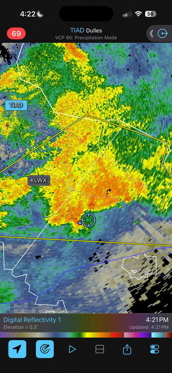
-

Saturday, July 18, 2026 Thunderstorm/Severe Weather Potential
Damage In Tolland replied to weatherwiz's topic in New England
Not with these low clouds /fog and 67/65. It’s another congrats Waterbury to DXR Southwest -
Like clockwork whenever we have an event.
-

E PA/NJ/DE Summer 2026 Obs/Discussion
RedSky replied to PhiEaglesfan712's topic in Philadelphia Region
It is very smokey -
KDIX radar down. Not great timing
-

2026 Mid-Atlantic Severe Storm General Discussion
wxmeddler replied to Kmlwx's topic in Mid Atlantic
I haven't seen any reports of non-tree based damage. Most stuff I've seen has been tree damage that seems 60 mph or less. -

Saturday, July 18, 2026 Thunderstorm/Severe Weather Potential
CoastalWx replied to weatherwiz's topic in New England
I think you could get clipped. -
E PA/NJ/DE Summer 2026 Obs/Discussion
RedSky replied to PhiEaglesfan712's topic in Philadelphia Region
The activity in NW PA won't make it here before 9pm if I had to hazard a guess -

Central PA Summer 2026 Discussion/Obs Thread
mahantango#1 replied to Voyager's topic in Upstate New York/Pennsylvania
That Tamaqua split is affecting the rainfall for your friends including me southwest of your locale. -
Based on radar, I will be out watering the garden later