All Activity
- Past hour
-

Wet late Monday 6/22 or another Fizzle?
nw baltimore wx replied to Weather Will's topic in Mid Atlantic
Making up ground, but the back edge is in sight. Probably won’t get to an inch today but grateful that today delivered after yesterdays near shutout. -

2026-2027 Super El Nino
GaWx replied to Stormchaserchuck1's topic in Weather Forecasting and Discussion
Thanks, Chris. Related to the PDO, I saw this quote today: “Waters around Japan have been cooling quite a bit lately while warming north/northeast of Hawaii.” -

E PA/NJ/DE Summer 2026 Obs/Discussion
RedSky replied to PhiEaglesfan712's topic in Philadelphia Region
Back edge approaching -
Really fortunate with storms around dark yesterday and a little shower this morning - picked up 1.15. Going to need it as it looks like we bake soon.
-
The fairly reliable S stream super-Nino fire hose pattern doesn’t typically start til after the end of the active part of the tropical season, i.e. not til November usually.
-
.80 since yesterday.
-

E PA/NJ/DE Summer 2026 Obs/Discussion
Birds~69 replied to PhiEaglesfan712's topic in Philadelphia Region
Down to 65...
-
Over 1” now counting yesterday
-
https://easternmassweather.blogspot.com/2026/06/forecast-intense-el-nino-potential.html
-

2026-2027 Super El Nino
40/70 Benchmark replied to Stormchaserchuck1's topic in Weather Forecasting and Discussion
https://easternmassweather.blogspot.com/2026/06/forecast-intense-el-nino-potential.html -
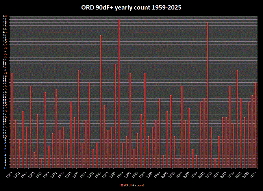
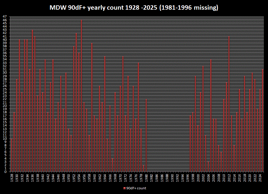
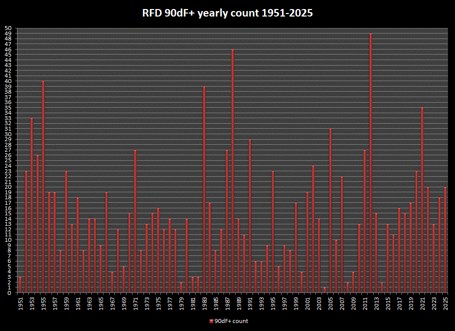
Joe, since your tracking 90dF+ days each year, thought I'd look at the longer period stns on your list, and graph the yearly counts as reference. Unfortunately, MDW has a 15 yr gap.
-
Absolutely, sorry if that came off as having a “winner” or “loser”. It’s a discussion board, so it was a little funny that after 6 paragraphs about the overuse of “heat dome”, that Tip writes a one liner about a massive heat dome in the long range. Hopefully we can see a little of the humor in that sequence of posts.
-
One hopes that before that happens the developing super-ultra-mega-El Nino will break through with a southern stream fire hose.
-
I don’t have a clear forecast like I do during Niña years. I think a moderate to strong Nino seems likely. Normally, I would just go with 70-75% of days at AN for temps with normal to AN rainfall for E TN. The other 25-30% at normal. However, recent winters have featured 2-3 weeks of bitterly cold weather west of the Apps. Granted, that is likely due to a Niña signal. However, I think those cold shots may well just be a feature of winters right now…regardless. Normally, Nino winters are rainy and dreary with a lot of clouds…nothing remarkable with temps. But…the warmer temps may well cause some convection in MJO regions 8-1-2 near the dateline. That would cause some colder rotations with the MJO which has had strong influence during recent winters. The current June CANSIPS parks a monster EPO ridge over AK for most of the winter. The seasonal Euro is warmer over the East. I lean AN for temps this winter DJF, but that is not a strong lean. As for snow, Nino winters need to really be weak to weak-moderate for best chances. But for E TN peeps, the chances for coastal storms increase which creates a feast for famine pattern during many winters. Normally, Nino winters are kind of back loaded with normal Fall temps preceding that. I could see kind of a meh December with chances in Jan and Feb.
-
E PA/NJ/DE Summer 2026 Obs/Discussion
RedSky replied to PhiEaglesfan712's topic in Philadelphia Region
Epic snow hole -
The rain in Garner was fun-for about 8 minutes I guess it was measurable lol
-
E PA/NJ/DE Summer 2026 Obs/Discussion
RedSky replied to PhiEaglesfan712's topic in Philadelphia Region
Light stratiform rains what a novelty -
Radar looking better up this way currently, heavy rain at this time with that blob area moving NE over my location.
-
Practicing for the blockbuster winter of 26/27. Get your snowblower lubed and ready to go.
-
It sucks to be you. I think i got .22" in 30 minutes this morning, and it's still pouring. You need to move up to the land of the luscious green grass.
-
. 02
-

2026-2027 Super El Nino
bluewave replied to Stormchaserchuck1's topic in Weather Forecasting and Discussion
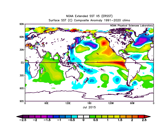
When the warm pool extends from Japan to California it allows the PDO to move closer to neutral. The key to watch going forward will it be able to get positive and hold it. Recent years the daily PDO values have rebounded back closer to neutral but couldn’t get into sustained positive territory. When the PMM was this strong going into the summer of 2015, the PDO was at +1.65. July 2015 +1.65 PDO vs May 2026 -PDO at -1.60 https://www.ncei.noaa.gov/pub/data/cmb/ersst/v5/v6/index/ersst.v6.pdo.dat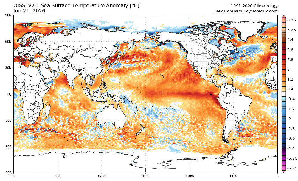
-
That was just enough of a shower to stabilize the atmosphere. Now when the line behind this one gets here....POOF!
-

Central PA Summer 2026 Discussion/Obs Thread
mahantango#1 replied to Voyager's topic in Upstate New York/Pennsylvania
No rain here since last evening. I guess the snook holds special powers to get rain. - Today
-

2026-2027 Super El Nino
PhiEaglesfan712 replied to Stormchaserchuck1's topic in Weather Forecasting and Discussion
We can probably ignore 2021, since there was no el nino. 1991, with the robust el nino, is probably the better analog. That one bucked the trend, and was an extremely warm spring and summer in the Eastern US. The thing about 1991 was that there was a major volcano in mid-June (which screwed things up), and don't have that (yet) this year.


