All Activity
- Past hour
-
I've always agreed with all of this. I just don't see it as settling the main question
-
I'm at the reststop a few miles north of 84 on the Thruway. A little slush in the parking lot, but highway still wet. Nice to see it snowing though. Saw a little white rain mix not too many miles west of the river, then to very wet snow north of Suffern. Snowing nice here and close to freezing. It went from 50 in lower Westchester to 43 at the TZ. This would have been a fun ride without the traffic in the Bronx and lower WC.
-

Minor snow possible sunday 12/14/25
NEG NAO replied to WeatherGeek2025's topic in New York City Metro
Thats true he should change it to Snowfall . Light to moderate possible. -

December 2025 regional war/obs/disco thread
FlashFreeze replied to Torch Tiger's topic in New England
Rain has switched over to snow in Winsted 36° -

Minor snow possible sunday 12/14/25
MJO812 replied to WeatherGeek2025's topic in New York City Metro
Defintely -
Minor snow possible sunday 12/14/25
MJO812 replied to WeatherGeek2025's topic in New York City Metro
How do you know ? Its still a few days away. -
Weatherbell needs to get its act together but @Weather Willis on point!!
-

Winter 2025-26 Short Range Discussion
Radtechwxman replied to SchaumburgStormer's topic in Lakes/Ohio Valley
Hoping tomorrow pans out here. Sat seems to keep trending more south and weaker each run. At least on gfs. -
The title of this thread says snowstorm
-
Lake effect snow warning for tomorrow
-
This is due to the overall climate warming since the 1970s and not an expansion of UHI. Even cooler surrounding areas are wall to wall AC usage now from May to September when they weren’t in the past. The warming in rural, suburban, and urban areas has been proportional.
-

12/12: The little Friday clipper that could? Or won't.
mappy replied to dailylurker's topic in Mid Atlantic
Sure is pretty up here!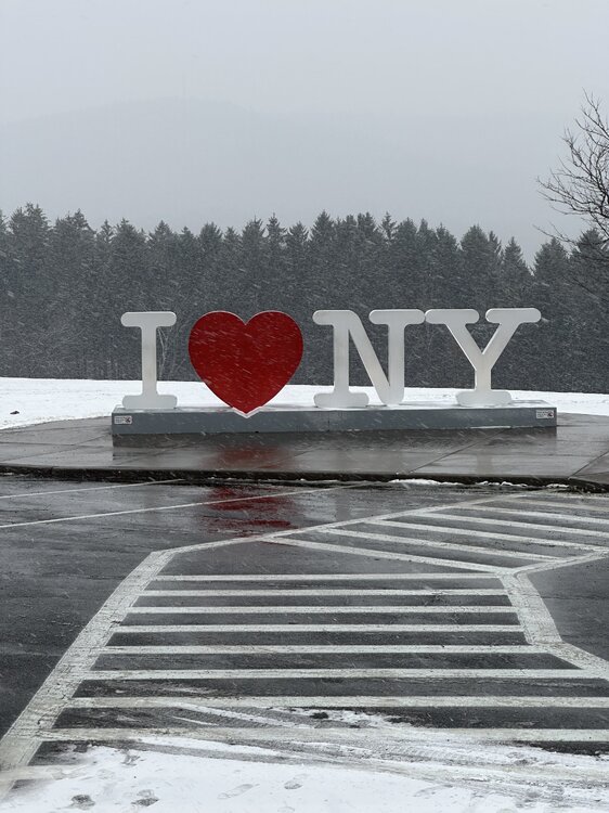
-
Bullshit. I was born and raised in Queens. My parents are now wall to wall AC from May thru Sept. Something that never happened before. The place just doesnt cool off at night anymore
-
We will accept our downsloping snow shower in Frederick and we will like it.
-
4” at base snow plot.

-
Minor snow possible sunday 12/14/25
NEG NAO replied to WeatherGeek2025's topic in New York City Metro
Who was saying a coastal storm was going to develop with significant accumulations ? 1-3 some areas 3 or 4 is the max potential for this set up with C -1 in some areas.......C-1 is also possible in most areas - will be a now casting event IMO -

Minor snow possible sunday 12/14/25
cleetussnow replied to WeatherGeek2025's topic in New York City Metro
Plenty of time for wafflng and whiffing. Reelaaaax. -

Minor snow possible sunday 12/14/25
snowman19 replied to WeatherGeek2025's topic in New York City Metro
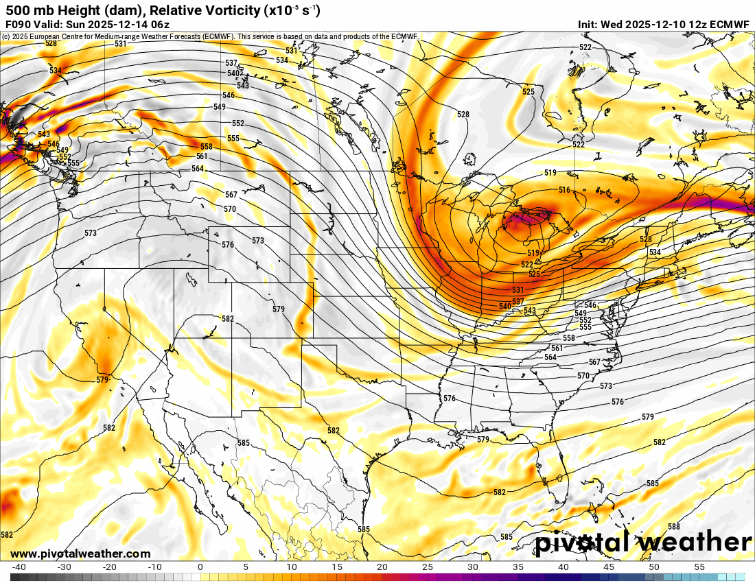
Just IMO, Sunday is going to turn into glorified arctic FROPA. I think the setup is not good for a coastal storm…positively tilted trough, raging fast flow, progressive, forward lean PNA ridge, no “traffic”/block in the Atlantic to slow the flow down and cause a jam so a wave can form, deepen and come up the coast. Snow showers, squalls, etc…..coatings/dustings up to an inch? Sure. A coastal low forming, slowing down, deepening and coming up the benchmark? I’m not seeing it. If I’m wrong, tear me to bits on Monday morning -

December 2025 regional war/obs/disco thread
HoarfrostHubb replied to Torch Tiger's topic in New England
Just warm enough here that my road wasn't bad during the dog walk. Part of it might be the condition of the road... not really smooth is an understatement -

December 2025 Short/Medium Range Forecast Thread
Matthew70 replied to John1122's topic in Tennessee Valley
The wind and windchill here definitely stings. The sun went away quickly this morning.. Sunday afternoon that windchill is going to absolutely be brutal. -
So yeah…H5 comparison valid 6z Sunday. We want the PV back toward Mackinac Island…not the QB/ON border. EC > NAM > GFS > ICON

-
Agreed, WB needs to get its act together....several times over the last week it keeps freezing up....guess not missing anything this GFS run...
-
UHI was already well established in NYC as early as 1896. Notice the more than +10° low temperature difference between Central Park and rural areas in August 1895. LGA and JFK UHI began to increase with the Queens urbanization and population growth expansion in the 1920s. So this isn’t much of a change from the current 10°+ difference between NYC-LGA-JFK and surrounding areas when UHI episodes are more pronounced like during summer heatwaves and radiational cooling during the winter. Data for August 9, 1896 through August 9, 1896 Click column heading to sort ascending, click again to sort descending. NY NY CITY CENTRAL PARK WBAN 82 NJ NEWARK LIBERTY INTL AP WBAN 76 NY WORLD TRADE CENTER WBAN 75 NJ PATERSON COOP 75 NY BRONX COOP 75 NJ PLAINFIELD COOP 73 NJ ELIZABETH COOP 73 NY PORT JERVIS COOP 72 NY SETAUKET STRONG COOP 72 CT MIDDLETOWN 4 W COOP 72 NY WEST POINT COOP 71 CT BRIDGEPORT COOP 71 NY BRENTWOOD COOP 70 CT COLCHESTER 2 W COOP 70 CT NORWALK COOP 69 CT WATERBURY ANACONDA COOP 69 CT NEW LONDON COOP 69 NJ CHARLOTTEBURG RESERVOIR COOP 67 Data for August 10, 1896 through August 10, 1896 Click column heading to sort ascending, click again to sort descending. NY NY CITY CENTRAL PARK WBAN 80 NJ NEWARK LIBERTY INTL AP WBAN 78 NY WORLD TRADE CENTER WBAN 77 NY BRONX COOP 77 CT BRIDGEPORT COOP 76 NJ PATERSON COOP 75 NY WEST POINT COOP 75 NY SETAUKET STRONG COOP 75 NJ PLAINFIELD COOP 74 NJ ELIZABETH COOP 74 CT NORWALK COOP 74 CT WATERBURY ANACONDA COOP 74 CT NEW LONDON COOP 73 CT COLCHESTER 2 W COOP 73 NY BRENTWOOD COOP 72 CT MIDDLETOWN 4 W COOP 72 NY PORT JERVIS COOP 71 NJ CHARLOTTEBURG RESERVOIR COOP 69 Data for August 11, 1896 through August 11, 1896 Click column heading to sort ascending, click again to sort descending. NY NY CITY CENTRAL PARK WBAN 81 NJ NEWARK LIBERTY INTL AP WBAN 78 NY BRONX COOP 78 NY WORLD TRADE CENTER WBAN 76 CT NEW LONDON COOP 75 NJ PATERSON COOP 74 NJ PLAINFIELD COOP 73 NJ ELIZABETH COOP 73 CT BRIDGEPORT COOP 73 NY SETAUKET STRONG COOP 73 CT WATERBURY ANACONDA COOP 72 NY PORT JERVIS COOP 71 NY WEST POINT COOP 71 CT MIDDLETOWN 4 W COOP 71 CT COLCHESTER 2 W COOP 71 NY BRENTWOOD COOP 70 CT NORWALK COOP 69 NJ CHARLOTTEBURG RESERVOIR COOP 67
-
For being too far north. Dang
-
Fringed