All Activity
- Past hour
-

December 2025 Short/Medium Range Forecast Thread
Daniel Boone replied to John1122's topic in Tennessee Valley
As usual, got some decent Year's snow wise but some not so good as well. One great one (2011) One terrible (1990) . -
Looks like a burst of rain and snow coming... probably elevationally dependent. Bright banding evident on radar.
-
A tradition unlike any other!
-
Latest Natty Blend. At this range its a great tool to use for guidance.
-

Winter 2025-26 Short Range Discussion
ChiTownSnow replied to SchaumburgStormer's topic in Lakes/Ohio Valley
I like the optimism.. need to will it to happen -
This has nothing to do with the SAI. The most recent 30 year data reflecting the warmer climate leaves no doubt as to the relationship. Back in the colder climate era the relationship was much weaker than it has become. Part of this is due to weather patterns becoming more repetitive in a warmer climate probably owing to local tropical SSTs resulting in non-linear convective temperature forcing thresholds being crossed. I understand that the most extreme warming has only occurred over the last 15 to 30 years. So we have a new emergent climate state that is different from the previous colder era. We don’t have the luxury anymore of a relatively stable global temperature regime as was the case from 1880 through 1982. So you had a much longer period where there was only a small increase in temperatures. It gave us a 100 years of correlations to work out and use. I understand that you may have some hesitancy in using the newer correlations derived over the shorter period. But I have been using numerous relationships from this new and warmer period that have been serving me well. But it’s not a 100 year data set to draw from like we had back in the older and colder climate era.
-
Scrolling down my past posts and found these gems:
-
Don't hate this look and its a bump up from 6z
-
And for what it’s worth, I think this upcoming “torch” is more of a gently above average type of deal for the upper south than 70s and golf weather. It looks like we’re going to be flooded with Pacific air, which isn’t exactly a torch signal - usually just a signal for a lot of 50s and low 60s sprinkled in. Torch to me is “tune up the lawnmower” weather cause it might start growing again.
-
Pretty similar. Nice to see at this point.
-
Looks like thread time... Edit: just saw the new thread...
-
I think point 1 is what I was trying to illustrate though. Maybe not on here, but I saw dozens of talking heads ignoring other parameters surrounding winter weather potential in the south as if the MJO is the only driver. I just don’t believe that it is. It has to be taken with a grain of salt and many big storms have occurred in less than ideal phases. So we actually agree on more than you think, I should’ve just added more context. It matters but it’s one drop in the very large bucket of things we need to get right to deliver an impactful winter weather event.
-
We seem to get screwed in most scenarios out our way
-
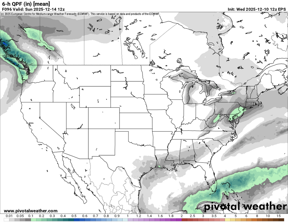
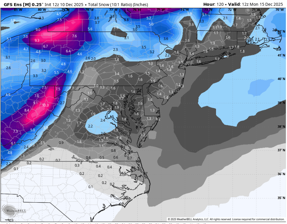
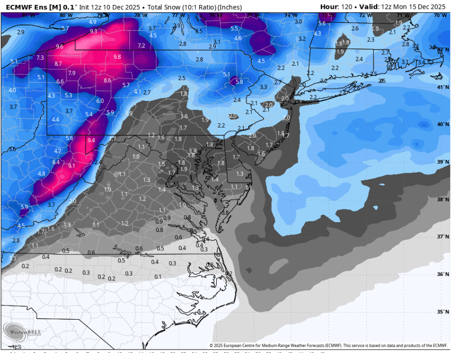
12z GEFS vs 12z EPS, take your pick.
-
The 12Z model consensus is coming in for Mon lows at ~20F for ATL and ~17-20F for RDU.
-
Still liking late Saturday into Sunday. 1-3 type deal might be more like 2-5 if all our stars align. Hopefully its a stripe of precip right through the heart of the region so we all get in on it.
-
-
I believe the term is snowissist
-

Central PA Winter 25/26 Discussion and Obs
Voyager replied to MAG5035's topic in Upstate New York/Pennsylvania
So it was 44 in Allentown. Just over the Blue Mountain here south of Tamaqua. 32 and heavy snow...
-
I think it’s def worth a trip to the Northern Mountains for this one (Avery county). All guidance seems to indicate this one will rip up here. Biggest concern would be getting here before 8 or 9 as blizzard conditions will set in.
-

Winter 2025-26 Short Range Discussion
Baum replied to SchaumburgStormer's topic in Lakes/Ohio Valley
Ground zero. -

December 2025 regional war/obs/disco thread
Cold Miser replied to Torch Tiger's topic in New England
And once it disappears we can move on to the wet mess at the end of the week. -
I vote myself, since I'm a narcissist who wants my backyard to get THE MOST snow.
-
Everyone should get their skiing in rn it’s just unbelievable

-
EPS might actually be more bullish than the OP by a touch for Sunday.


