All Activity
- Past hour
-

2025-2026 ENSO
40/70 Benchmark replied to 40/70 Benchmark's topic in Weather Forecasting and Discussion
Yes, I do expect a +PNA month of January. -

November 2025 general discussions and probable topic derailings ...
weatherwiz replied to Typhoon Tip's topic in New England
Woke up to the first coating of snow on the season this morning! Coating may be too strong of a word though...maybe a sprinkle of snow...like loading mashed potatoes up with salt -

November 2025 general discussions and probable topic derailings ...
CT Rain replied to Typhoon Tip's topic in New England
Yeah it's def been running warm. -
No idea. I never look at 45 day snow maps lol.
-

Central PA Fall Discussions and Obs
mahantango#1 replied to ChescoWx's topic in Upstate New York/Pennsylvania
Around 10:45pm last night had a sleet/snow shower. -

Fall 2025 Medium/Long Range Discussion
A-L-E-K replied to Chicago Storm's topic in Lakes/Ohio Valley
gonna be rough when the sswe ends up burying I95 while we do the cad thing -

NNE Cold Season Thread 2025-2026
EMontpelierWhiteout replied to Boston Bulldog's topic in New England
Looking nice! Do you know why the mountain cams on the Stowe website are not up for public viewing? I’ve been able to locate the replay loop in other places, but not any live feeds. On the site, they just have the annoying “Webcam Currently Off Line” for all. -
lol. You are in. Midseason form. Relax. When do weeklies ever show this on Nov 17
-
Still a few LE flurries and very light snow showers lurking out here.
-
2025-2026 ENSO
40/70 Benchmark replied to 40/70 Benchmark's topic in Weather Forecasting and Discussion
If they were all the same, Outlooks would be easy. -
32 degree's in Mahwah, Gorgeous chilly morning on my last shift here at the communications center.
-
I caught flurries in the middle of the night on a camera I have along the woods line. The flurries didn’t trigger it but the two bucks going back and forth did. Hard to tell exactly how big but one appeared to be a young 4 pointer, the other larger one appeared to be at least a 6, possibly 8, pointer. As a result of the clouds it didn’t get a cold as forecast here, off by about 5 degrees, low of 34.
-

November 2025 general discussions and probable topic derailings ...
WinterWolf replied to Typhoon Tip's topic in New England
Oh agreed. .I’ve said similar. He may be taking a morning swim down there as we type? -
our cutters showing a real propensity to go poof and the big flip cold looking like a dud sad
-

November 2025 general discussions and probable topic derailings ...
CoastalWx replied to Typhoon Tip's topic in New England
I mean it’s a warmer spot, but I’ve been commenting about that station for over a year. There’s no reason why it should be the warmest spot in all of SNE in this setup. -
November 2025 general discussions and probable topic derailings ...
WinterWolf replied to Typhoon Tip's topic in New England
He’ll be posting palm tree pictures in the corners of buildings…and saying the low today was 45 -
The only Southeast ridge component that really matters is on the day of the storms like last winter. Even if a Southeast ridge isn’t showing in the means, if a storm is tracking through the Great Lakes we will get the Southeast ridge to flex for a day before the storm cuts to our west or hugs the I-78 to I-84 corridor. Long range ensembles never show this since they are too smoothed out in the long range and have trouble seeing the individual shortwaves. We really haven’t seen a gradient pattern work closer to NYC in a long time due to this for more than light snows.
-
Bad sign.
- Today
-
I think we need a title change here. No warm season here this A.M.
-
Yeah, but that isn’t really cold for those areas either. Remember, the lows in the UHI zones are proportional to the ones outside the urban areas. Since you aren’t going to get very cold with radiational cooling if the airmass isn’t that cold to begin with. Even places which great radiational cooling like Saranac Lake have only dropped to 19° by November 16th. This is the 2nd warmest minimum on record through 11-16 at the airport. Time Series Summary for SARANAC LAKE ADIRONDACK REGIONAL AP, NY Warmest lows 9-1 to 11-16 Click column heading to sort ascending, click again to sort descending. 1 2006-11-16 21 1 2 2025-11-16 19 0 3 2016-11-16 18 0 - 1998-11-16 18 0 5 2014-11-16 17 0 6 2010-11-16 16 0 - 2000-11-16 16 1 8 2021-11-16 15 0 9 2024-11-16 13 0 10 2011-11-16 12 0 - 2009-11-16 12 0 12 2008-11-16 11 0 - 2005-11-16 11 1 14 2015-11-16 10 0
-
38 right now
-
Still lightly snowing as I wake up , looks like maybe an inch or two - really pretty as I look out. Hope we get days like this down here this winter.
-
 Deep winter run this morning with the wind
 -
November 2025 general discussions and probable topic derailings ...
CoastalWx replied to Typhoon Tip's topic in New England
KHVN 40 when everyone else there is well mixed and 36-37. We toss KHVN. @BrianW -
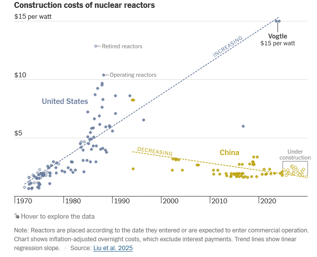
I'm open to any non-fossil energy source, let the market decide. In the case of nuclear, the US will need to lower cost to deploy significant volume. https://www.nytimes.com/interactive/2025/10/22/climate/china-us-nuclear-energy-race.html?unlocked_article_code=1.vk8.p953.GyoqfHxUqxEK&smid=url-share