All Activity
- Past hour
-
Good wins for the Hoos today. Pounded Duke (offense finally showed up after being MIA for a few weeks). And in basketball, man - we haven't played high level teams yet, but the team is looking good. Dropped 104 on Marshall.
-

November 2025 general discussions and probable topic derailings ...
powderfreak replied to Typhoon Tip's topic in New England
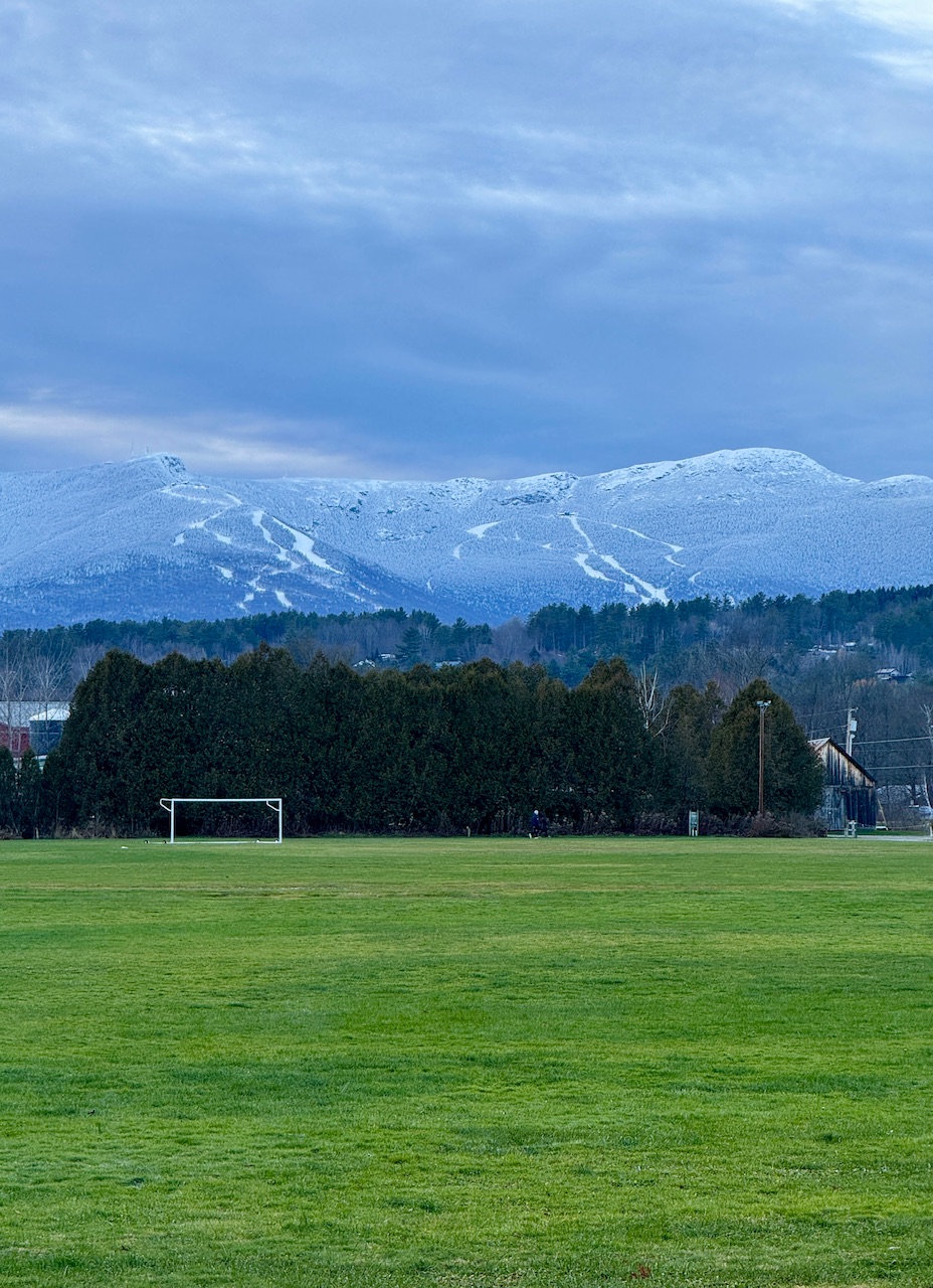
Got up to 37F today, melting out the valley fields to reveal deep green. Snow really is poor man’s fertilizer… less than a 1,000ft higher saw a high of 32F and very healthy snowpack on the ground.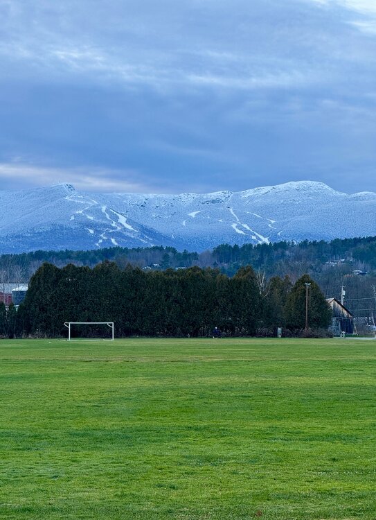
-
Hit 74 here. Dew points in the low 50's made for a really nice day. No breeze did mean mosquitoes though.
-
Welcome to the high Sierra Cordillera, Lucy's Washington DC Edition 2025. It finally managed to fall to 32 degrees. Ground FINALLY managed to eke out a white coating. This, at 9,000 feet in the Sierra in mid to late November! https://www.mammothmountain.com/on-the-mountain/mammoth-webcam/main-lodge It's finally cold enough for snow at 9,000 feet and the snow is super light. Damn. Out of moisture. Sound familiar, DC'ers? We're playin the Lucy game here at Mammoth this winter! Local meteorologists up here are frazzled and humbled as storm tracks end up all over the place! They are not even sure that Mammoth will ever see enough snow to open up at all anytime soon! That damn RADAR is making me want to walk the Ledge again! All the heavy stuff is moving northwest, AWAY from Mammoth! DAMN! Its been so damn bad up here that the resort was forced to POSTPONE the Saturday Opening! Why, you ask? NO SNOW! Just mud. It's called La Nina. That means warmer than normal in the Sierras, Deep South and Texas. Cold as fuck in the Midwest, Great Lakes and Mid Atlantic and the Northeast will be particularly hard hit with Ice Age-magnitude cold and snows. At this rate I will soon be so despondent about thin snows at Mammoth, that I will soon be ripe for reaping. It's THAT BAD! Gonna have to develop some snow futility markers for up here! Like the fact that it hits 32 degrees then bounces back up to 33 - all night long. This ensures hardly more than an inch accumulates - even though it snows hard as heck all night, like last night.
-
.thumb.png.4150b06c63a21f61052e47a612bf1818.png)
November 2025 general discussions and probable topic derailings ...
HIPPYVALLEY replied to Typhoon Tip's topic in New England
35/34. Had some moderate rain earlier, but lighter now. About .20” tonight: -

Pittsburgh PA Fall 2025 Thread
TheClimateChanger replied to TheClimateChanger's topic in Upstate New York/Pennsylvania
Severe Weather Statement National Weather Service Pittsburgh PA 1031 PM EST Sat Nov 15 2025 PAC059-125-160345- /O.CON.KPBZ.TO.W.0024.000000T0000Z-251116T0345Z/ Washington PA-Greene PA- 1031 PM EST Sat Nov 15 2025 ...A TORNADO WARNING REMAINS IN EFFECT UNTIL 1045 PM EST FOR SOUTHERN WASHINGTON AND NORTHEASTERN GREENE COUNTIES... At 1031 PM EST, a severe thunderstorm capable of producing a tornado was located near Waynesburg, moving east at 45 mph. HAZARD...Tornado. SOURCE...Radar indicated rotation. IMPACT...Flying debris will be dangerous to those caught without shelter. Mobile homes will be damaged or destroyed. Damage to roofs, windows, and vehicles will occur. Tree damage is likely. This dangerous storm will be near... Jefferson Boro around 1040 PM EST. Fairdale around 1045 PM EST. Other locations impacted by this tornadic thunderstorm include Clarksville, Amity, Deemston, Carmichaels, Rices Landing, Marianna, Centerville, and Nemacolin. PRECAUTIONARY/PREPAREDNESS ACTIONS... TAKE COVER NOW! Move to a basement or an interior room on the lowest floor of a sturdy building. Avoid windows. If you are outdoors, in a mobile home, or in a vehicle, move to the closest substantial shelter and protect yourself from flying debris. Tornadoes are extremely difficult to see and confirm at night. Do not wait to see or hear the tornado. TAKE COVER NOW! Please report severe weather by calling 412-262-1988, posting to the NWS Pittsburgh Facebook page, or using X @NWSPITTSBURGH. && LAT...LON 4000 8040 4010 8035 4002 7992 3999 7995 4001 7997 4001 8000 3999 7999 3998 8001 3995 8000 3995 7996 3992 7992 3985 7996 TIME...MOT...LOC 0331Z 292DEG 37KT 3998 8023 TORNADO...RADAR INDICATED MAX HAIL SIZE...<.75 IN $$ Rackley -

2025-2026 ENSO
Daniel Boone replied to 40/70 Benchmark's topic in Weather Forecasting and Discussion
But, if you throw upstream blocking in there you would get the Central US Cold undercut into the East. Probably equivalent to low Ph 7 without it imo Larry. Maybe not into the SE east of the Apps and South of NC. -

2025-2026 ENSO
Coach McGuirk replied to 40/70 Benchmark's topic in Weather Forecasting and Discussion
That too, I remember when I got my cat from the SPCA it was snowing one of those years. -

Central PA Fall Discussions and Obs
WmsptWx replied to ChescoWx's topic in Upstate New York/Pennsylvania
Tornado-warned storm out in SWPA. -
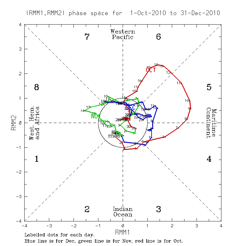
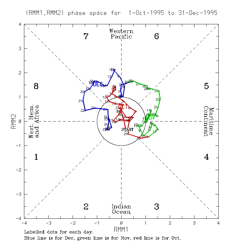
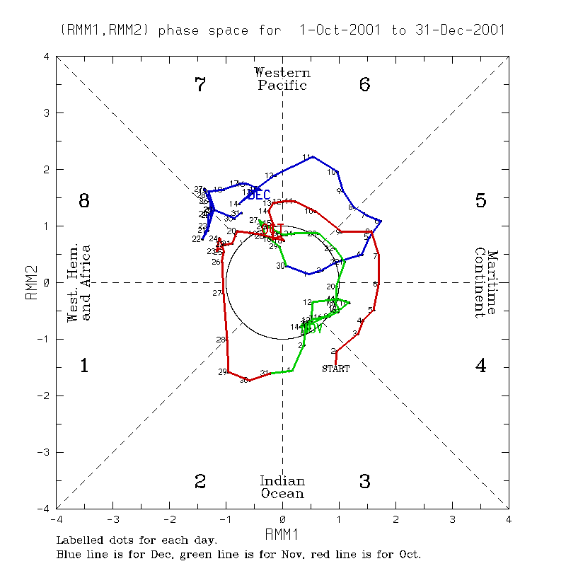
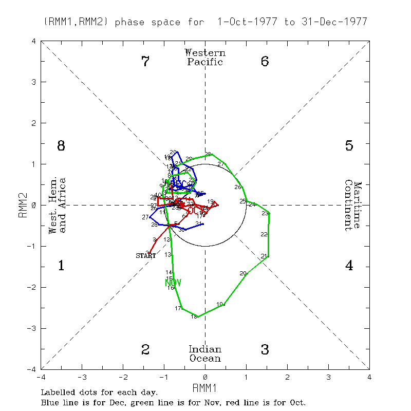
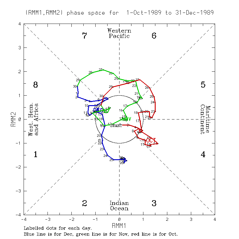
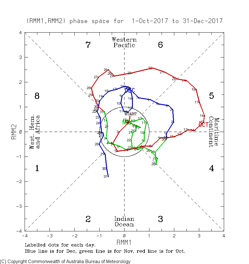
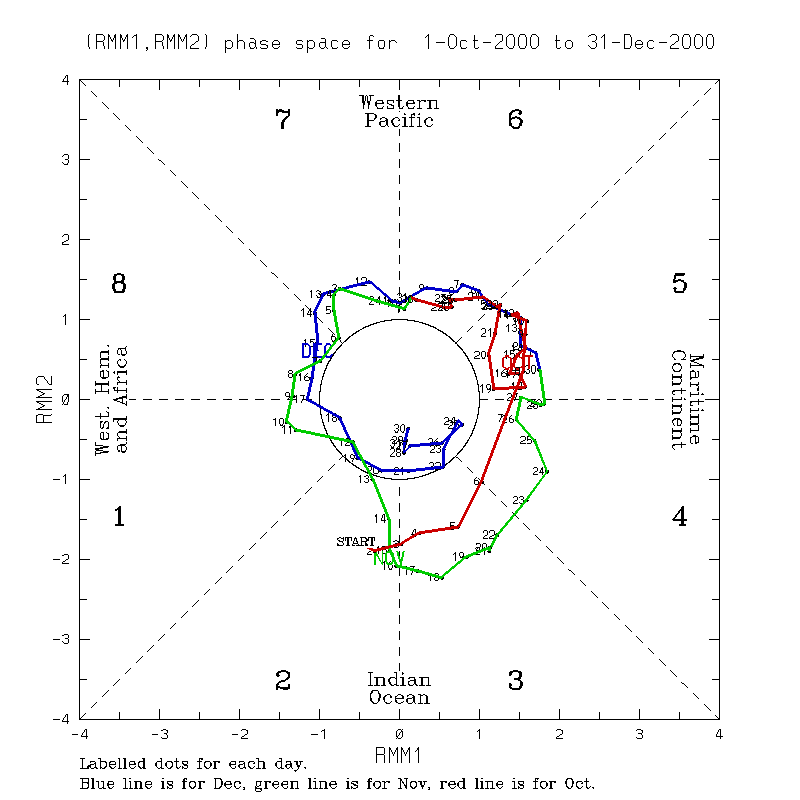
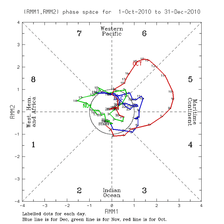
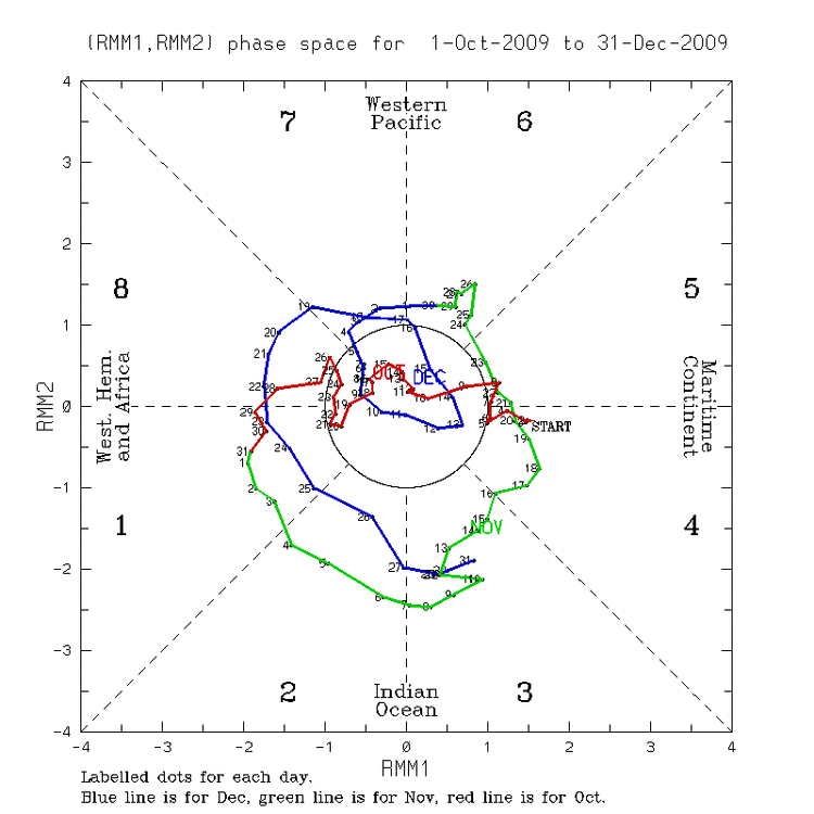
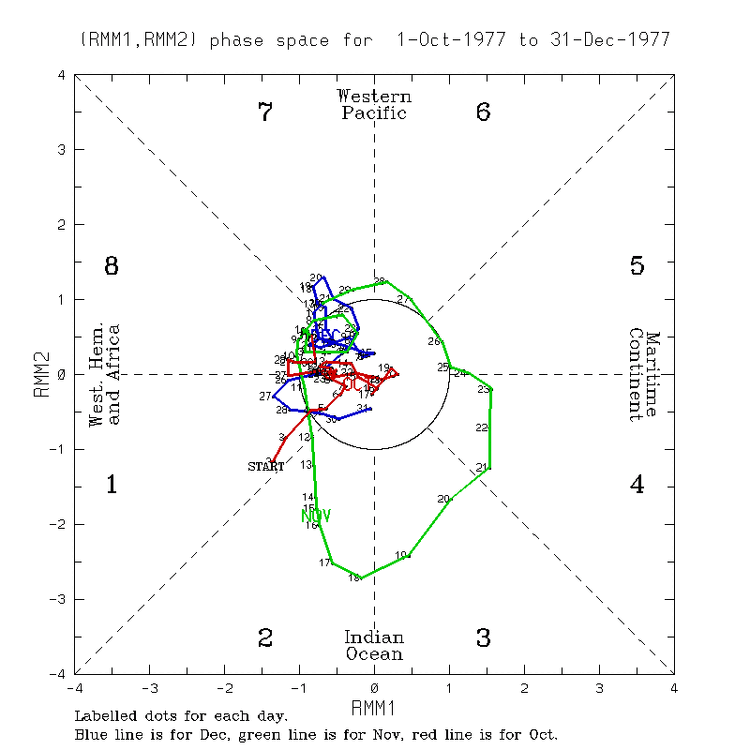
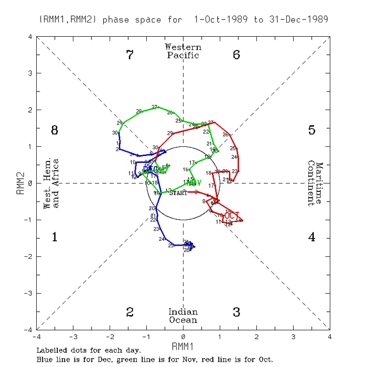
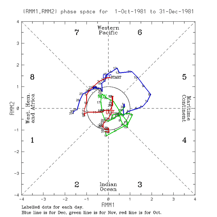
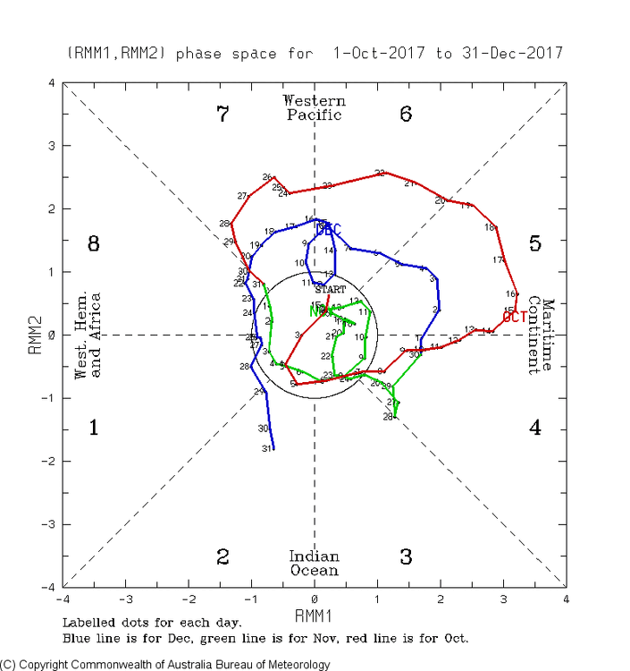
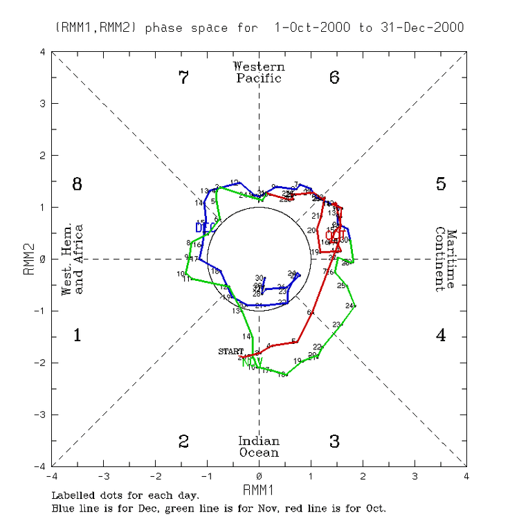
The cold E US Dec phase 7 periods were mainly during weak to low end moderate amplitude phase 7s (including inside the circle, which your map includes). Instead, the extended GEFS and Euro are forecasting a strong phase 7, which rarely was cold. Using Baltimore as a midpoint for the E US, these were the coldest in phase 7: 1. -11: 12/16-20/2010 ph 7 near to just inside COD 2. -11: 12/17-19/2009 ph 7 just outside COD: 3. -7: 12/26-31/2001 ph 7 moderate: 4. -7: 12/9-19/1995: this ph 7 was strongest that was cold…but this is the only exception that was almost as strong as the ext-EPS but still not nearly as strong as the ext-GEFS 5. -6: 12/4-9/1977 ph 7 (the cold one is well inside the COD, not the one that comes out later which wasn’t cold): 6. -6: 12/5-8/1989 ph 7 just outside to right on COD: 7. -6: 12/15-25/1981 ph 7 just outside to just inside COD: 8. -5: 12/9-11/2017 this is the ph 7 going into the COD (not the one further out 12/17-20): 9. -5: 12/11-14/2000 ph 7 moderate


- Today
-
-
Close lightning strike and good thunder. 0.16”
-
I see that being thrown around and also 2013-2014.
-

November 2025 general discussions and probable topic derailings ...
dryslot replied to Typhoon Tip's topic in New England
Upper levels are marginal on temps, H92 -0C, H85 -1C, Early season that's not going to cut it for all snow here. -

Central PA Fall Discussions and Obs
Ruin replied to ChescoWx's topic in Upstate New York/Pennsylvania
what was really bad about all the wind it took so many of the leaves down that just started to change. -

November 2025 general discussions and probable topic derailings ...
rimetree replied to Typhoon Tip's topic in New England
Decent pelt fest now. 39/32 -
yeah forecast was way off here too
-
2025-2026 ENSO
Coach McGuirk replied to 40/70 Benchmark's topic in Weather Forecasting and Discussion
2012-2013 is a good year as a model for 2025-2026. -

November 2025 general discussions and probable topic derailings ...
alex replied to Typhoon Tip's topic in New England
Started as sleet and freezing rain here. 25.7F. Let’s get to the other side of this BS so we can get back into an upslope flow -

November 2025 general discussions and probable topic derailings ...
512high replied to Typhoon Tip's topic in New England
36/ .14” has some sleet on the grill cover, lol baby steps…. -
Interesting development in the North Atlantic. SST'S becoming favorable for a -NAO this Winter. https://x.com/Aigle_e/status/1989420648234668098?s=20
-

November 2025 general discussions and probable topic derailings ...
dendrite replied to Typhoon Tip's topic in New England
31.7° FZRAPL -
Interesting SST development in the North Atlantic : https://x.com/Aigle_e/status/1989420648234668098?s=20 Another factor increasing - NAO Odds this Winter.
-
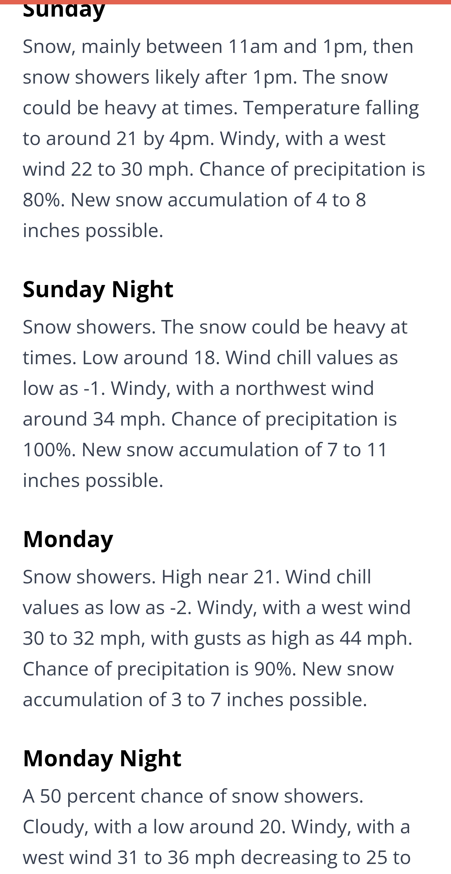
Mansfield summit depth record highest shows 30" on Monday and Tuesday, with 33" on Wednesday, 28" on Thursday, and 30" on Friday. All of those could be in jeopardy. A record breaking week of snow depths?
-
BWI: 17.8 DCA: 11.4 IAD: 19.5 RIC: 8.5 SBY: 7.5