All Activity
- Past hour
-
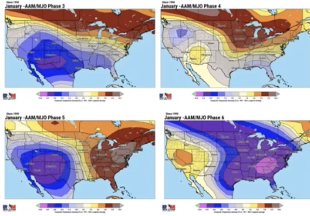
This was released by BAMwx: Thoughts? I’m going to need to research this myself to feel comfy with BAMwx’s idea of the highly counterintuitive idea of a very cold E US on average during La Niña (-AAM) Jan phase 6 periods. They’re saying this probably because GEFS is forecasting phase 6 going into mid-Jan. I can do the analysis but it will take time. Actually anyone can do it! In the meantime, I’ll continue to root for weak to moderate 8-1-2 over 6 or even 7. @donsutherland1@bluewave
-

January 2026 regional war/obs/disco thread
moneypitmike replied to Baroclinic Zone's topic in New England
-

Pittsburgh/Western PA WINTER ‘25/‘26
colonel717 replied to Burghblizz's topic in Upstate New York/Pennsylvania
-
Crazy storm, ended up with 12" from the storm , then another 6" from LES last night. Calling for another 8-12" thru New Years. Finally got my power back this afternoon. After last season's snow/ice and this year just about ready to move somewhere much warmer.
-

New Years Day 2026 - 1st snows of the new year possible
kdxken replied to Baroclinic Zone's topic in New England
My daughter who is a orthopedic PA calls it distal radius fracture season . -
This thread is pure comedy sometimes, a play on emotional instability, the cause of rising psychotherapy costs in the southeast. Ridges gonna ridge.
-

New Years Day 2026 - 1st snows of the new year possible
HoarfrostHubb replied to Baroclinic Zone's topic in New England
Of course…biguns are preferable, and I see your point of view. But anything that can add to the “pack” and to my little ski area helps. -
New Years Day 2026 - 1st snows of the new year possible
kdxken replied to Baroclinic Zone's topic in New England
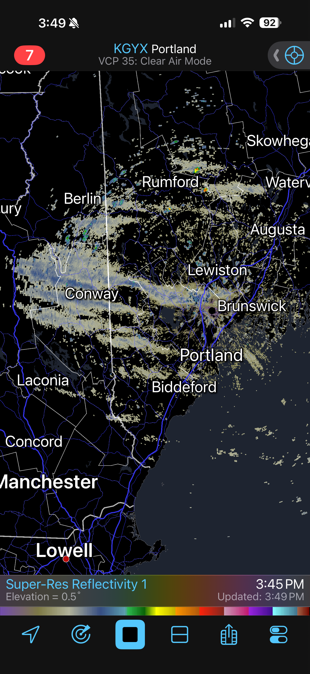
You mean like this?.jpg.bc27d18c54478a1ad219f71e96344bf1.jpg)
-

Pittsburgh/Western PA WINTER ‘25/‘26
Mailman replied to Burghblizz's topic in Upstate New York/Pennsylvania
Didn't do squat down here today; however, i did have to venture to Johnstown this morning. It was rippin' good on 711 between Donegal and Ligonier this morning. -
Final event snowfall totals1.5" - Home0.9" - ORD0.8" - RFD…2025/26 Season Snowfall...18.8" - RFD18.3" - ORD" - Home
-
A few streamers moving thru the lakes region

-
I could see that 12-18" panning out near the lakeshore in far NE OH, especially in northern Ashtabula County, but Geauga County won't get that much IMO. The downside of grouping multiple counties together in a warning. It just seems like there will be too much of a break after snow lifts out of there tonight, and I think stuff will progress through too quickly with the cold front tomorrow evening. There's definitely a shot Geauga County verifies a warning at some point (they haven't yet...) but the 12-18" feels inflated there. We'll see, as I've been wrong before. Nice band ongoing at the moment.
-
Wouldn’t surprise me if east end of li ends up with 2”
-

New Years Day 2026 - 1st snows of the new year possible
ORH_wxman replied to Baroclinic Zone's topic in New England
Seems like most should get measurable but 2”+ will probably be in isolated pockets or out on/near Cape. -
Neither the GFS nor the EURO have meaningful QPF in central NC until January 14!
-
You either leave happy with a buzz, Or you leave pretty intoxicated............
-

New Years Day 2026 - 1st snows of the new year possible
klw replied to Baroclinic Zone's topic in New England
Can we wait until 2026 starts before we comment about how lame the year has been so far? -
I’m calculating that the Dec NAO will come in near -1, easily the most negative Dec since 2010. This is the first moderate to strong Dec -NAO during active Dec sunspots since 2002, when sunspots were 135. I’m estimating Dec of 2025 SSN to be 120.
-
good. If you are floundering in your attempts to catch anything, just don't sit there carping about it.
-

New Years Day 2026 - 1st snows of the new year possible
SJonesWX replied to Baroclinic Zone's topic in New England
i am really looking forward to my 0.5" awesome -

New Years Day 2026 - 1st snows of the new year possible
dryslot replied to Baroclinic Zone's topic in New England
These have had surprises over the past years once they hit the Atlantic they can develop rapidly. -

Central PA Winter 25/26 Discussion and Obs
Mount Joy Snowman replied to MAG5035's topic in Upstate New York/Pennsylvania
Saw that, and still ranting about the performance of the models. I also saw he openly admitted to preferring warm weather and said he doesn't root for big snowstorms. Alrighty then. -

New Years Day 2026 - 1st snows of the new year possible
TauntonBlizzard2013 replied to Baroclinic Zone's topic in New England
Yeah, NAM is a good illustration how this may play out. Couple inches for SE Mass and Downeast Maine. Flurries elsewhere. If it could get going even 6 hours earlier, could get more involved -

January 2026 regional war/obs/disco thread
weatherwiz replied to Baroclinic Zone's topic in New England
It does have that look to it. -

January 2026 regional war/obs/disco thread
Typhoon Tip replied to Baroclinic Zone's topic in New England
The GEFs version above looks like a bit of an undercutting/split flow...