All Activity
- Past hour
-
Or to fuel your own cyclical climate change denialism.....
-
remember the drought
-

2025-2026 ENSO
40/70 Benchmark replied to 40/70 Benchmark's topic in Weather Forecasting and Discussion
This is because the 2023-2024 El Nino was partially masked and competing with the forcing from the WPAC warm pool, which wasn't present during 2015 and 2009. Warm ENSO episode(s) later this decade and into the early 2030s should herald a regime change....but if not, then we will know something is up. -
Bold take saying no HHH this summer! fully expect that to come by mid to late June
-

2025 hurricane season forecast contest -- enter by June 1st
Newman replied to Roger Smith's topic in Tropical Headquarters
16/7/3 -
Yea I had just looked at the models before I came on here. Was going to say something similar. Nice June weather, but no HHH on the visible horizon.
-
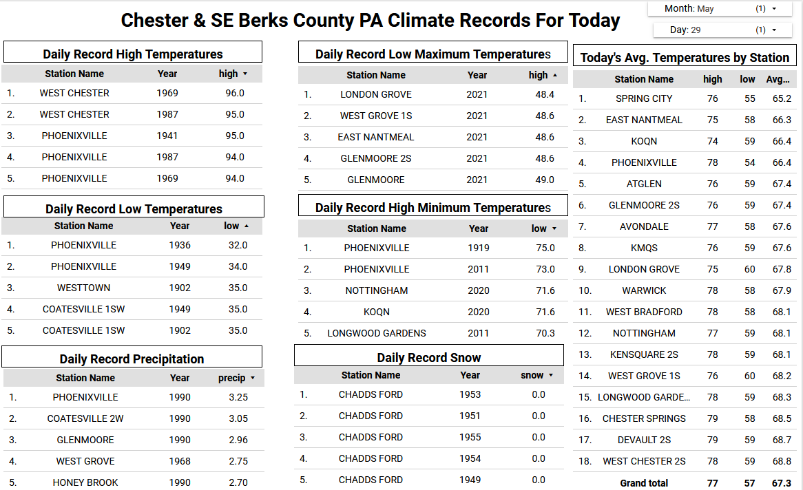
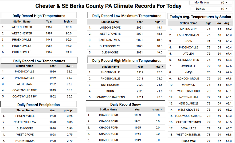
Some area rain totals yesterday ranged from as much as 2.66" at Nottingham to only 0.86" at Devault. Here in East Nantmeal with yesterday's 1.14" of rain we are now over 8 inches of rain for the month. This is the wettest May since I moved here in 2004. The wettest all-time May in Chester County goes way back to 1894. When from 11.54" at Kennett Square to as much as 14.60" fell in West Chester. Today will be dry but any break from the rain will be short lived as wet weather moves back in late tonight and will last off and on through much of Saturday. Finally sunny skies return on Sunday. On a climate note today marks the latest recorded freezing temperature here in Chester County when on this day back in 1936 Phoenixville recorded a low temperature of 32 degrees.
-

E PA/NJ/DE Spring 2025 Obs/Discussion
ChescoWx replied to PhiEaglesfan712's topic in Philadelphia Region
Some area rain totals yesterday ranged from as much as 2.66" at Nottingham to only 0.86" at Devault. Here in East Nantmeal with yesterday's 1.14" of rain we are now over 8 inches of rain for the month. This is the wettest May since I moved here in 2004. The wettest all-time May in Chester County goes way back to 1894. When from 11.54" at Kennett Square to as much as 14.60" fell in West Chester. Today will be dry but any break from the rain will be short lived as wet weather moves back in late tonight and will last off and on through much of Saturday. Finally sunny skies return on Sunday. On a climate note today marks the latest recorded freezing temperature here in Chester County when on this day back in 1936 Phoenixville recorded a low temperature of 32 degrees.
-
I wonder what the top winds were. Sources are saying 60mph and there is just no way. The winds were stronger than that.
-
1.55" was my total. Everything is so lush and green. And my post the other day about a nice weekend - yeah never mind. Scattered rain and even some thunderstorms both Saturday and Sunday it seems.
-
funny that you posted these. Sunday i was mowing my trail out back (keeps the ticks at bay), and there was a coyote right next to me, maybe 25 feet away. Then on Tuesday I was out there having an ice cold beer, and a bobcat ran down the trail, like 50 feet away. same bobcat was seen by next door neighbor in his backyard yesterday. Very cool stuff to see
-
.58" here so far
-
It's basically late Novie. Dec 20th, just getting going
-

Central PA Spring 2025
Itstrainingtime replied to canderson's topic in Upstate New York/Pennsylvania
Truly finished with 1.82" - I slowly tacked on an additional tenth long after radar returns were gone from my area. -
Not for a few more weeks....I'm a bit less optimistic overall than I originally was.
-

2025 Spring/Summer Mountain Thread
WxKnurd replied to Maggie Valley Steve's topic in Southeastern States
I’d like some dryness and sustained periods of sun at some point soon, but these temps sure are great! -
It was a crazy event. First time in my life we hit the basement lol. I told my wife it honk there’s a tornado outside
-

Spring 2025 Medium/Long Range Discussion
WestMichigan replied to Chicago Storm's topic in Lakes/Ohio Valley
Not liking the looks of this heading into summer.
-
Currently 59 degrees Picked up .28” yesterday and today so far .03” of rain. Appears the northern tier was and underachiever compared to most of you guys.
-
Gut say no, but we'll see. My largest grip this spring with all the rain is that my lawn SUCKS. Overseeding next spring after chasing away the damn grubs
-
Absolutely love it! Late spring of yore, reminds me of 30 years ago
-
0.59 in the bucket Wed - overnight into this morning here New Brnswck: 0.61 LGA: 0.52 EWR: 0.51 NYC: 0.50 JFK: 0.27
-
Yeah we have the same problem here in Baltimore county. They refuse to let us bring a tractor/4 wheeler on the fields to drag them. They have to line and set out the bases. We have a group of parents that will rake the entire diamond to get it playable. Oh and we are only allowed to use 2 bags of quick dry per field... any more than that, and the field is unplayable. It is just plain stupid. The tournament we were at in Elkridge this weekend... I was made aware that Howard county has the same issue as we do.
-
Records: Highs: EWR: 97 (1987) NYC: 97 (1969) LGA: 95 (1987) JFK: 99 (1969) Lows: EWR: 40 (1936) NYC: 43 (1902) LGA: 48 (2021) JFK: 46 (1949) Historical: 1877: A "terrific" two-day long sandstorm sandblasted Yuma AZ. (28th-29th) (Ref. The Weather Channel) 1947: An unprecedented late-spring snowstorm blasts portions of the Midwest from eastern Wyoming to eastern Upper Michigan. The heavy snow caused severe damage to power and telephone lines and the already-leafed-out vegetation. 1951 - A massive hailstorm, from Wallace to Kearney County in Kansas, caused six million dollars damage to crops. (David Ludlum) 1953 - A tornado, 600 yards wide at times, killed two persons on its 20 mile path from southwest of Fort Rice ND into Emmons County. Nearly every building in Fort Rice was damaged. The Catholic church was leveled, with some pews jammed four feet into the ground. (The Weather Channel) 1982: Two significant tornadoes ripped through southern Illinois. The most severe was an F4 that touched down northeast of Carbondale, Illinois then moved to Marion. The twister had multiple vortices within the main funnel. Extensive damage occurred at the Marion Airport. A total of 10 people were killed, and 181 were injured. 648 homes and 200 cars were damaged or destroyed, with total damages around $100 million. 1986: Hailstones over 3 inches in diameter pounded South Shore in Montreal, Quebec Canada causing over $65 million in damage. 1987 - Thunderstorms in West Texas produced softball size hail at Lamesa, and hail up to twelve inches deep east of Dimmitt. Thunderstorms also spawned seven tornadoes in West Texas, including one which injured three persons at Wolfforth. Thunderstorms deluged the Texas Hill Country with up to eleven inches of rain. Severe flooding along the Medino, Hondo, Seco, Sabinal and Frio rivers caused more than fifty million dollars damage. (Storm Data) (The National Weather Summary) 1988 - A powerful cold front brought snow and high winds to parts of the western U.S. Austin, NV, was blanketed with ten inches of snow, and winds gusted to 75 mph at the Mojave Airport in California. Strong southerly winds and unseasonably warm weather prevailed in the north central U.S. Glasgow, MT, equalled their record for the month of May with a high of 102 degrees. (Storm Data) (The National Weather Summary) 1989 - Wintry weather gripped parts of the northwestern U.S. for the second day in a row. Great Falls, MT, was blanketed with 12 inches of snow, which pushed their total for the winter season to a record 117.4 inches. Six inches of snow whitened the Cascade Mountains of Oregon. (The National Weather Summary) (Storm Data) 1990 - Afternoon and evening thunderstorms produced severe weather from north central Colorado to the northern half of Texas. Severe thunderstorms spawned four tornadoes, and there were seventy reports of large hail or damaging winds. Midday thunderstorms produced wind gusts to 90 mph at Hobart, OK, and produced up to three and a half inches of rain in eastern Colorado in four hours. (The National Weather Summary) (Storm Data) 2002: Parts of western New York State had up to 5,000 homes were without power at the peak of the storm from downing trees and power lines. Hail up to 1 inch in diameter was reported in Perry, Wyoming County. The training thunderstorms dropped 4 to 6 inches of rain in two to three hours in a localized area from Phelps to Newark. A State of Emergency was declared that was declared in Newark remained in effect for a week with most schools and businesses closed during that time. Nearly 300 basements were flooded and several roads covered with up to a foot of water remained closed for several days. (Ref. Wilson Wx. History)
- Today
-
Teleconnections support a more significant heat ~ D6 ... 12 at some range in there. The operational run blend is dodging that signal with a flattened, fast progressivity to the overall handling. It's not clear if this operational aspect is a bias, or a real a signal... Those two indicators are somewhat in conflict at this time. Just sayn' I wouldn't be very assured in a cooler look between D6 and 12... June 4-8th in particular is when a shallow -EPO teams up with a very strong -PNA, while the NAO is neutral positive, and while all this is happening, the operational heights just refuse to build the ridge through the teleconnector region - There were several run cycles up through about 2.5 days ago that were substantially warmer - actually better fits... The telecon part of this puzzle has not deviated since prior to then, thru it, and up until now, either. The operational runs have been oscillating more than less - right now, they are less. Sometimes when the operational blends disagree with the multi- ensemble source derivatives ( the -PNA ...+EPO... -AO...blah blah), they win. Other times, they lose ... This is probably like in the winter, when there is a loud signal for a large event in the extended, then we 'black out' for 3 days and never hear from it ... only to have it come storming back at 84 hours or whatever. We'll have to keep an eye on it as inCREdible temperature nerds with nothing better to to do than to monitor whether we make 88s out of 77s or not. hahaha. F, it's better than this recreating whining and complaining bs at least.