All Activity
- Past hour
-

2025 Spring/Summer Mountain Thread
Met1985 replied to Maggie Valley Steve's topic in Southeastern States
An absolutely beautiful morning with a low of 48 degrees. -
Despite the hype on twitter that there’s going to be a huge Atlantic tropical burst this month, this isn’t looking so hot
-
Well as Labor Day is behind us and School and Fall sports start, we look back on an amazing summer. Plenty of fun all around. Time to look ahead to 8 months of Autumn and maybe it snows again.
-

E PA/NJ/DE Autumn 2025 Obs/Discussion
Mikeymac5306 replied to PhiEaglesfan712's topic in Philadelphia Region
Not much to yak about. Even the tropics are fairly quiet. Need the rain though. Go Birds! -

Central PA Summer 2025
Mount Joy Snowman replied to Voyager's topic in Upstate New York/Pennsylvania
I’ve been meaning to make a post of this nature because, when I do my daily checks, I’ve been stunned by how many times this summer MDT has come in a good 2-5 degrees warmer than even CXY for daily lows. I know we’re all aware of MDT’s tendency to run high for minimums this time of year but it seemed especially egregious. They are routinely the warmest station in the state along with PHL. That’s why I had to laugh when that one guy popped in a while back to rant about MDT being too cold of a spot for our area. I didn’t bother responding but about spit out my drink haha. I’m not even in a cold spot relative to most of the forum and I can’t tell you how many times my low will be something like 54 and MDT’s will be like 60 ha. Speaking of, it was 54 when I left the house this morning. Carry on. -
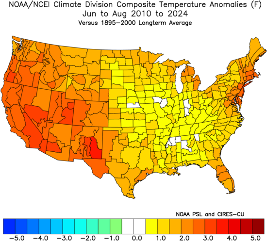
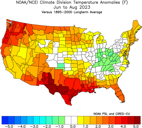
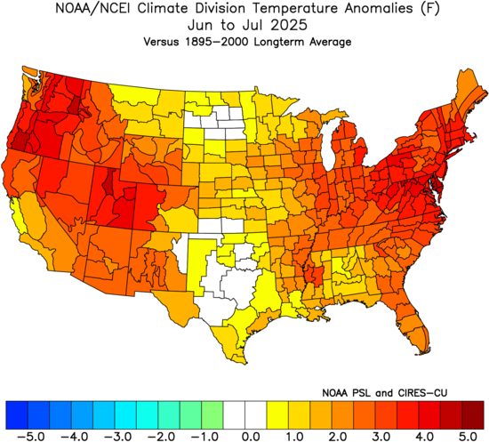
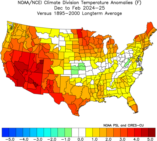
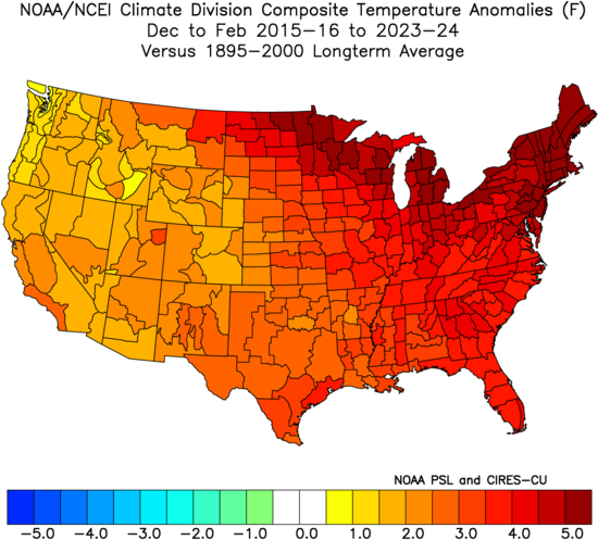
JJA 2023 was actually a little warmer against the long term averages. But since 2010-2025 has been so warm it felt cooler. You can see how this summer matched the 2010-2024 pattern with warmth in the East and West with cooler in the mid section of the nation. This is the same way that this winter felt colder by comparison to the much warmer winters since 15-16. But it was still warmer than the long term average in the Northeast.
-
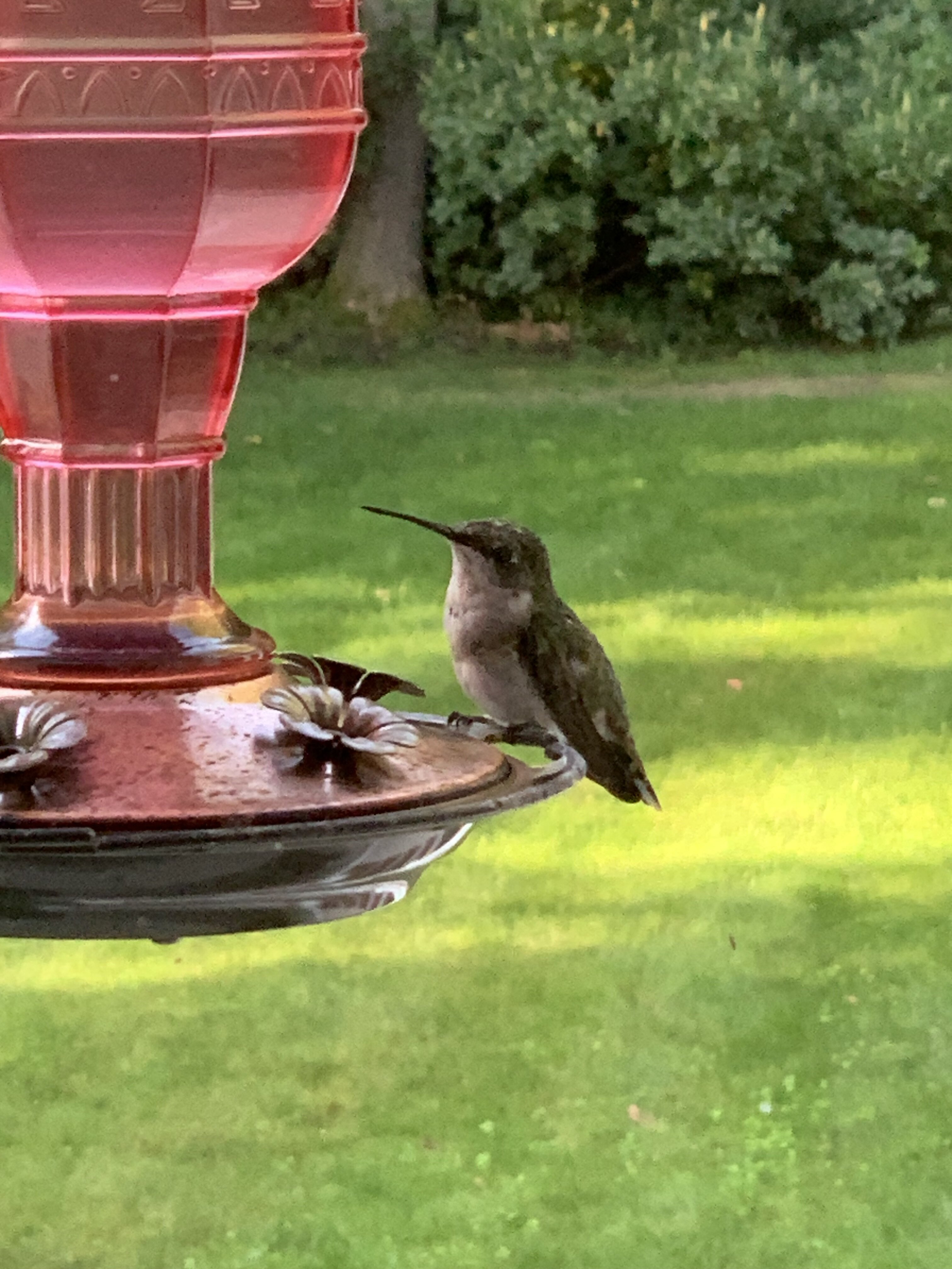
Sad to see the hummers making their final preps for migration but always glad to be of assistance to the coolest birds in town. It’s a long haul across the GoM to Central America so every sip counts for the little speedsters.

-

September 2025 OBS-Discussion centered NYC subforum
JustinRP37 replied to wdrag's topic in New York City Metro
What a very odd end to the summer. It really went out with a whimper. No big thunderstorms, no big heat after mid July, very quiet tropics so far, and things looking status quo for some time. Tick season also decreased substantially with the dry weather we have been experiencing. -
Lake levels are really low. Outdrives less then 18" from sitting on bottom in the slip. Here's an aerial of the Causeway this weekend Sent from my SM-S921U using Tapatalk
- Today
-
Both Harrisburg airports have remained at the same location since they started reporting weather obs. MDT records go back to 1992 while Harrisburg Capital Airport go all the way back to 1939. If you had any doubts that MDT records are questionable, as many have mentioned/joked since I purchased a home in 2019 and followed the forum, this summer's records are all the evidence you need. MDT monthly temp anomalies respectively: +1.3, +2.5, -2.6 = monthly average of +.4 (normal is ofter defined as +/- .5) Capital Airport monthly temp anomalies respectively: +.7, +1.2, -4.0 = monthly average of -.7
-
-
Great writeup as always. It's crazy how good you are at how the long range stuff works and you're not even officially a met lol. Jog my memory again on the PDO, we want it to be positive, correct?
-
Nighttime lows holding up temperatures here too. This summer: June High/Low: -0.3F / +1.9F July High/Low: -1.2 F / +3.2 F August High/Low: -3.6F / +0.9F I don't think this is too unusual around here either. Lows are being held up by higher moisture levels.
-
BFor the first time in a couple of days, the UKMET (0Z) has TCG for this. However, after moving WNW, then WSW for a short time, and then back to WNW, it dissipates at 16.4N, 48.3W: NEW TROPICAL CYCLONE FORECAST TO DEVELOP AFTER 72 HOURS FORECAST POSITION AT T+ 72 : 15.0N 35.4W LEAD CENTRAL MAXIMUM WIND VERIFYING TIME TIME POSITION PRESSURE (MB) SPEED (KNOTS) -------------- ---- -------- ------------- ------------- 0000UTC 05.09.2025 72 15.0N 35.4W 1011 28 1200UTC 05.09.2025 84 15.6N 37.0W 1012 26 0000UTC 06.09.2025 96 15.9N 39.8W 1012 28 1200UTC 06.09.2025 108 16.4N 42.7W 1012 32 0000UTC 07.09.2025 120 16.0N 45.7W 1013 29 1200UTC 07.09.2025 132 16.4N 48.3W 1013 29 0000UTC 08.09.2025 144 CEASED TRACKING
-
I had about 3.8" rain for July/Aug which is dry for this part of New England. I know some surrounding Franklin Co. towns are lower than that. Coming down Rt 2 tonight I could see premature leaf fade and droop, especially in that Fitchburg to Hubbardston corridor. There was also a few red lit swamp maples.
-
Ryan Hall video I was watching, he said 2010-11 was an 85 percent analog match for this coming winter. Not exactly sure where he's seeing that but it was very snowy that winter for my area at least.
-
-
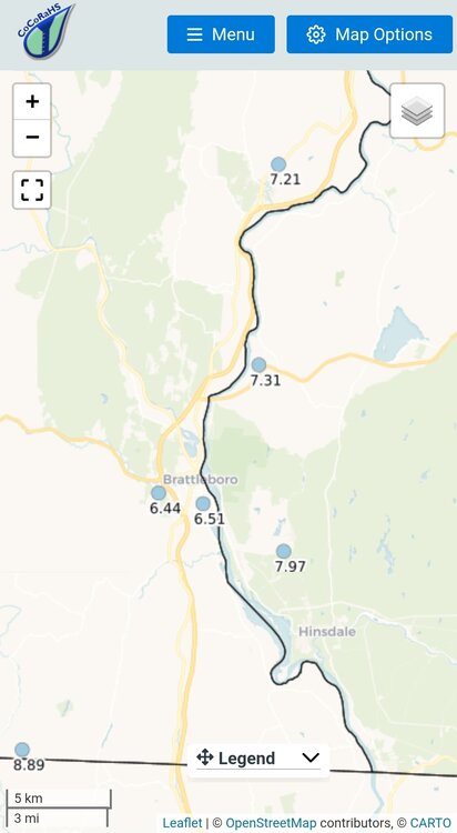
CoCoRaHS
-
 Then, by this logic, summer began on March 29 this year.
 -

2025-2026 ENSO
so_whats_happening replied to 40/70 Benchmark's topic in Weather Forecasting and Discussion
They have been in every season for some time now. While daytime does get to some extreme levels for the different times of the year consistently the nights are well above average in every season. The most noticeable of seasons at least around here has been in winter. I mean it was like 2 years ago I think we had one evening below 20F around Baltimore the entire winter the rest were in the 25-35 range, that is huge in winter around here. -

2025-2026 ENSO
TheClimateChanger replied to 40/70 Benchmark's topic in Weather Forecasting and Discussion
Rankings are also misleading these days too, because of so many recent years being anomalously warm. I suspect the CONUS finishes in 12th place for summertime mean. However, if it does so, it would be warmer than EVERY summer before 2006, except for the dust bowl juggernauts of 1936 & 1934. For those of us who were around in the 1990s, those seemed like insurmountable numbers. Not even scorching summers like 1995 and 1988 could surpass those. And so the 12th place finish really seems to undersell just how hot this summer was. In the 1990s or early 2000s, if someone came out and said this summer the CONUS would be hotter than every year except 1934 & 1936, everybody would recognize that is a VERY hot summer with massive cooling demands, etc. The media would be running constant stories about the heat and ramping up hysteria about climate change and a new dust bowl. That doesn't happen anymore. With that said, 1936 still holds the #1 slot (now tied with 2021). I think it's only a matter of time before we see a summer (or summers) that far surpass anything previously observed when you look at how many recent summers are in the top 10 nationally. It won't take much more warming to get us to that point. -
Makes sense given ENSO heaviest weighted . Throw in a good amount of upstream blocking and you would get a good look. Hopefully the QBO State along with NATL SST'S will help accomplish that. I saw a Forecaster saying 2010-11 was a favored analogue. Ryan Hall I believe. That type Pattern would be what would result with the Cansips Outlook with added blocking.
-
Occasional Thoughts on Climate Change
TheClimateChanger replied to donsutherland1's topic in Climate Change
If August comes in exactly at the 1991-2020 mean, summer would finish up around 73.22F. If August comes in at +0.2F, then the final summer tally would be 73.29F. If August comes in at +0.5F, the final summer value would be 73.39F. All of these are 12th warmest between 2018 (73.48F) and 2002 (73.16F). So I doubt it will finish in the top 11. Likely range 12th-15th, with 12th being most probable IMO. To put it another way, August can finish anywhere between 0.2F below and 0.7F above the 1991-2020 mean, and we'd still probably wind up in 12th place. -

2025 Spring/Summer Mountain Thread
Maggie Valley Steve replied to Maggie Valley Steve's topic in Southeastern States
Currently raining after a couple of showers yesterday and a couple today. Temperature is 60. -
Occasional Thoughts on Climate Change
TheClimateChanger replied to donsutherland1's topic in Climate Change
Should finish around 12th place IMO. The last PRISM update had us at +.22F for the month of August compared to 1991-2020 mean. Even if NCEI comes it at -0.3F below the 1991-2020 mean, we'd still have a summer mean of 73.12 (13th place). To drop to 15th place, August would need to come in around -0.5F below the 1991-2020 mean, which would give a summer mean of 73.06F. I don't think PRISM would be off that significantly, especially with the sign of the departure.


.thumb.png.4150b06c63a21f61052e47a612bf1818.png)


