All Activity
- Past hour
-
27.3 (Muttontown) & 30.9 (Syosset) for morning lows.
-
April is now a winter month.
-
This is really impressive after the heat of last week. Not too often do you have highs in the 90s followed so close to freezing temps.
-
Of course it does. I am going to the Savannah Bananas on Sunday. We can’t have nice weather for that…
-
Looks like the warm water helped keep DCA (and a few other spots "on" the water) well short of freezing. A few other locations may also have escaped. But IAD hit 27, BWI 30
-
24 for the low.
- 740 replies
-
- 1
-

-
- april showers bring may..
- rain
- (and 2 more)
-
It was 40F at 3am in Colonial Beach so I was like no way. Surprised to wake up to see 32 at 630am! Winds must have died down.
-
32 on the dot along the former, and sure to be future tropical shores of the Potomac.
-
24 currently… plants that have opened hopefully will recover.
-

Central PA Spring 2026 Discussion/Obs Thread
mahantango#1 replied to Voyager's topic in Upstate New York/Pennsylvania
23 this morning,. I wonder how much damage this hard frost and freeze did to the fruit trees and other vegetation overnight? -
31.8 for the low... already back above freezing.
-
30 Ridgely Mesonet reporting 28
-
24 for the low here
-
29.3 so far.
-

2026-2027 El Nino
bluewave replied to Stormchaserchuck1's topic in Weather Forecasting and Discussion
FWIW, the April dynamical mean is up to 2.06 for the ONI. This is significantly ahead of 2023 and 2016 at the same point. 2023 was at 1.54 and 2.10 verified. April 2015 was at 1.30 and 2.80 verified. So for the 2 most recent strongest El Niños the spring forecast barrier resulted in too weak a forecast. https://iri.columbia.edu/our-expertise/climate/forecasts/enso/current/ April 2026 Average, Dynamical models 0.764 1.120 1.438 1.709 1.763 1.951 2.060 1.856 1.810 April 2024 Average, Dynamical models 0.460 0.785 1.098 1.328 1.406 1.481 1.547 1.473 1.386 April 2015 Average, dynamical models 0.8 1 1.2 1.3 1.4 1.3 1.3 1.3 1.1 -
29 imby
-
22.7° what a morning
-
Don’t see the Pope’s tropical forecast for NNE.
-

Central PA Spring 2026 Discussion/Obs Thread
Superstorm replied to Voyager's topic in Upstate New York/Pennsylvania
25.7F this morning in Lancaster. . -

Chester County PA - Analytical Battle of Actual vs. Altered Climate Data
chubbs replied to ChescoWx's topic in Climate Change
Very important to remove the station changes in Chester county. The county stations moved frequently and bigger changes were cooling. The station population has cooled with time mainly due a shift from towns to more rural sites. Our older stations are warmer than the county as a whole, particularly in the 1930-48 period when Phoenixville was much warmer than other local stations on summer afternoons; and, West Chester and Coatesville were in built-up towns. I can match NCEI perfectly by; 1) excluding the 3 big station moves: Coatesville in 1946+48, Phoenixville in 1948 and West Chester in 1970; and, by removing the temperature difference between stations by taking station anomalies to a common period. Raw data without the contamination of station changes. The chart below shows that NCEI has met their objective of taking out station changes to reveal the weather and climate signal in the raw data. Of course, if you leave in all the station changes you won't match NCEI or any other scientific analysis. This thread is a strawman based on bad analysis and confirmation bias.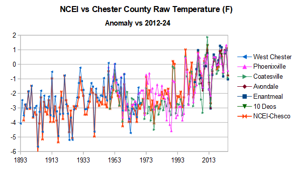
-
6z gfs has temps in the 40s with rain on Saturday. Disgusting.
-

Central PA Spring 2026 Discussion/Obs Thread
Mount Joy Snowman replied to Voyager's topic in Upstate New York/Pennsylvania
27 when I left the house, could yet inch lower. Color me impressed. Also had a trace of rain yesterday. Carry on. -
23 we freeze don't worry the heat will be here soon enough and ill be crying
-
30.2
- Today
-
Bring it!!!! I'm still sceptical though. It is nice to see a change in pattern though. I can't believe how brown it is around here. We basically just got out of dormancy here, and went right back.


