All Activity
- Past hour
-
GEFS slightly snowier at 18z over 12z lol .
-

E PA/NJ/DE Winter 2025-26 Obs/Discussion
Ralph Wiggum replied to LVblizzard's topic in Philadelphia Region
I mean, why not right?
-

“Cory’s in NYC! Let’s HECS!” Feb. 22-24 Disco
Chrisrotary12 replied to TheSnowman's topic in New England
Amen! -

2/22-23 "There's no way..." Storm Part 2
Solution Man replied to Maestrobjwa's topic in Mid Atlantic
I like that very much, yes I do -
HECS
-

2/22-23 "There's no way..." Storm Part 2
SomeguyfromTakomaPark replied to Maestrobjwa's topic in Mid Atlantic
With a massive storm bombing right off the coast nothing would surprise me really. Could easily go boom for us. Will it? Who knows, hopefully. -

Central PA Winter 25/26 Discussion and Obs
Blizzard of 93 replied to MAG5035's topic in Upstate New York/Pennsylvania
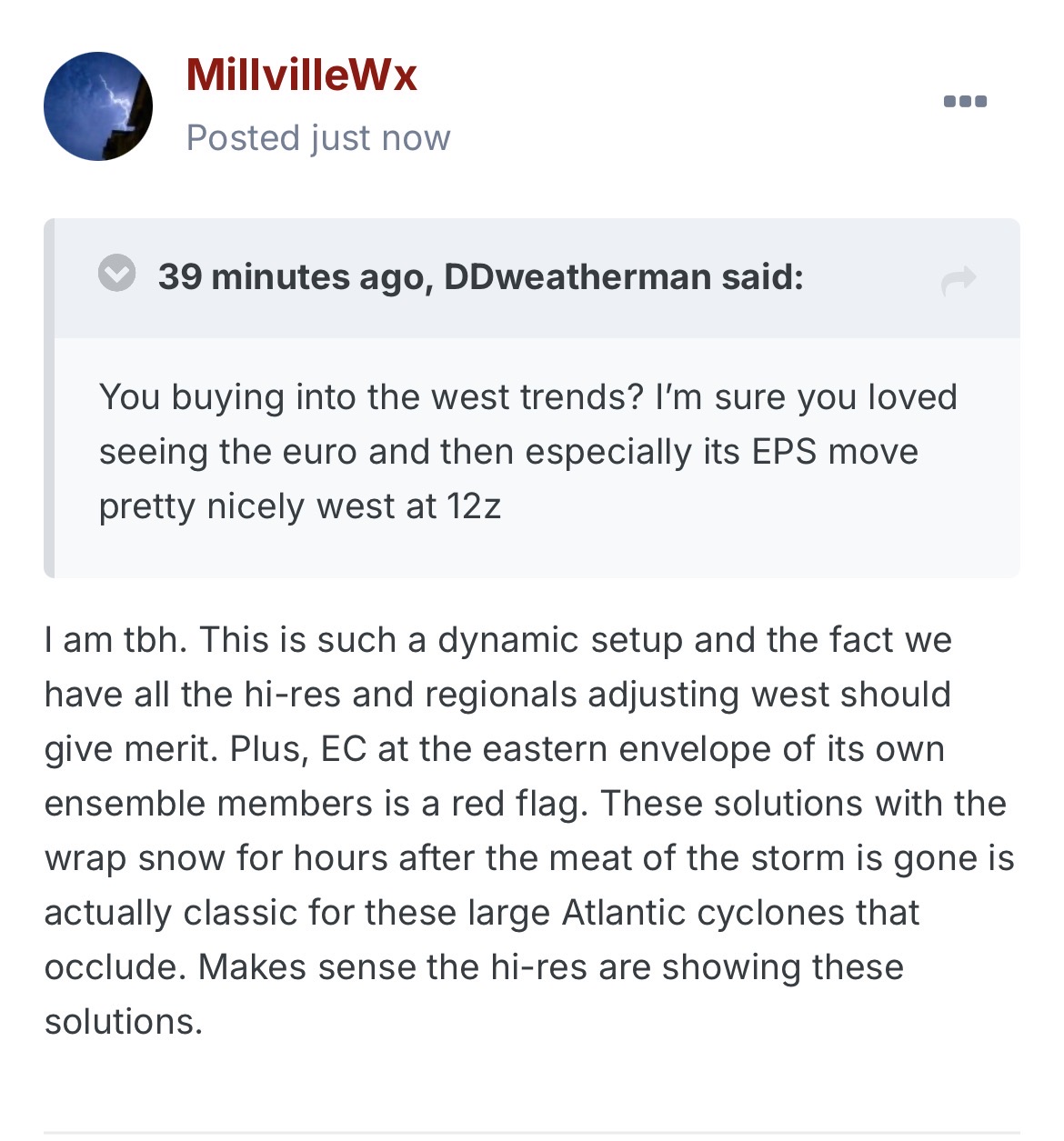
Great exchange here between @MillvilleWx & @DDweatherman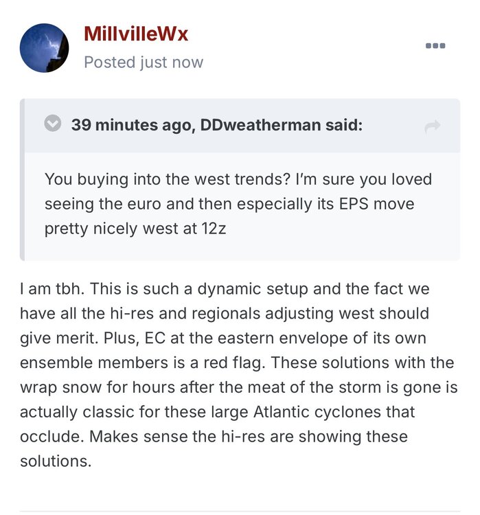
-
100% this. GFS would be a total nuisance.
-
I like your positivity and I agree, it could go boom. Just haven't seen that enough on guidance (a 25-50 mile shift west) to believe. But, I did just read Millvilles post and he actually knows what he's talking about unlike me lol. Maybe I should have more confidence
-
Correct!
-
Wouldn't give it weight for another 12 hours.
-
I'm a realtor in the area. Let me know when you're ready to move back to the snow country of NW Frederick County and I'll help you out lol.
-
I am in there! And solution man. And yes I am watching that.
-
2/22-23 "There's no way..." Storm Part 2
SomeguyfromTakomaPark replied to Maestrobjwa's topic in Mid Atlantic
I wouldn’t be shocked with 8 or more, very dynamic situation and some of these mesos are throwing us bands through Monday morning. Tuck this a tiny bit more and boom. -
we have a professional weather met craig allen doing the weekend weather on wcbs 2.
-
Start time down in Ocean City NJ? 10am?
-

“Cory’s in NYC! Let’s HECS!” Feb. 22-24 Disco
ORH_wxman replied to TheSnowman's topic in New England
Anyone SE of an ASH-HFD axis doesn’t have much to worry about unless youre being greedy and demand 2 feet. -
I am tbh. This is such a dynamic setup and the fact we have all the hi-res and regionals adjusting west should give merit. Plus, EC at the eastern envelope of its own ensemble members is a red flag. These solutions with the wrap snow for hours after the meat of the storm is gone is actually classic for these large Atlantic cyclones that occlude. Makes sense the hi-res are showing these solutions.
-
lol you weenies are a trip
-

Richmond Metro/Hampton Roads Area Discussion
jlewis1111 replied to RIC Airport's topic in Mid Atlantic
anyone have the 18z gfs snow map thanks -
my point and click!!!! holy.... Sunday Snow, possibly mixed with rain, becoming all snow after 3pm. High near 37. Breezy, with an east wind 15 to 20 mph. Chance of precipitation is 80%. New snow accumulation of 1 to 3 inches possible. Sunday Night Snow. The snow could be heavy at times. Low around 31. Windy, with a north wind 20 to 30 mph, with gusts as high as 45 mph. Chance of precipitation is 100%. New snow accumulation of 12 to 18 inches possible. Monday Snow, mainly before 1pm. The snow could be heavy at times. Areas of blowing snow between 9am and noon. High near 35. Windy, with a northwest wind 25 to 30 mph decreasing to 20 to 25 mph in the afternoon. Winds could gust as high as 45 mph. Chance of precipitation is 80%. New snow accumulation of 3 to 7 inches possible.
-
Latest forecast for my yard is 9-13 late tomorrow/tomorrow night, and 1-3 on Monday. Just a tad less for Easton. Hoping to get home late Monday afternoon. Roads should be decent by then.
-
Wow. Love to see UKMET on board. Going out for the night and hoping I don’t come back to any major swings lol
-

“Cory’s in NYC! Let’s HECS!” Feb. 22-24 Disco
Damage In Tolland replied to TheSnowman's topic in New England
Absolutely -
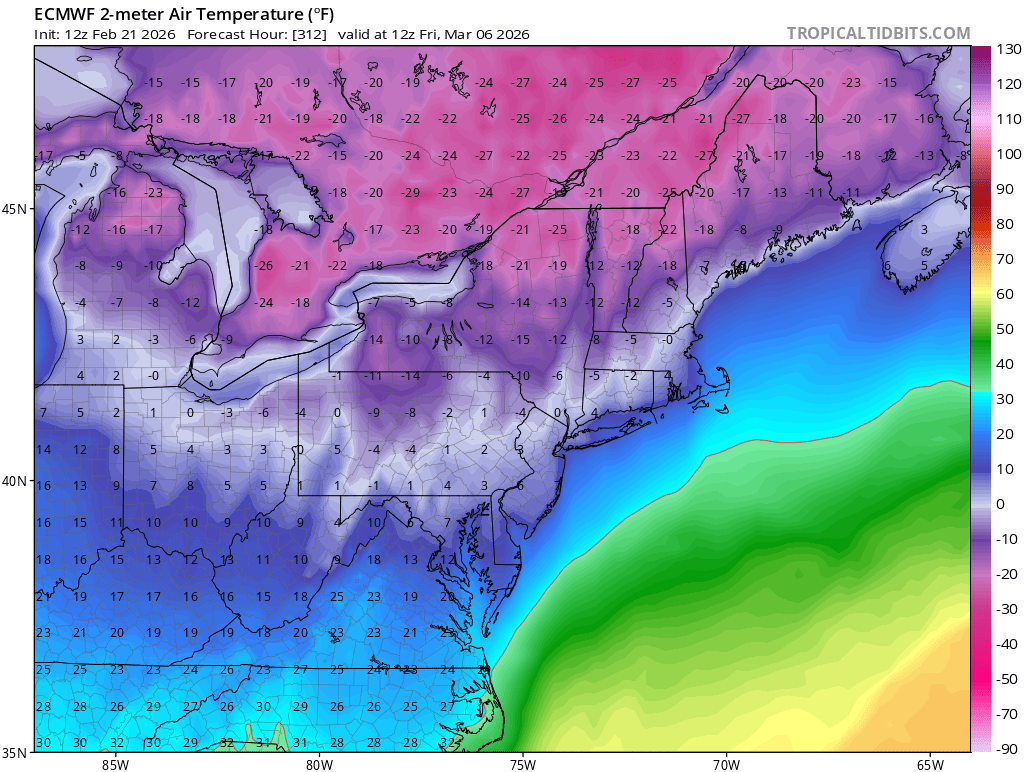
This gradient scares the shit out of me