All Activity
- Past hour
-
Had a 45 min period of very light rain/sprinkles. Picked up a T.
-

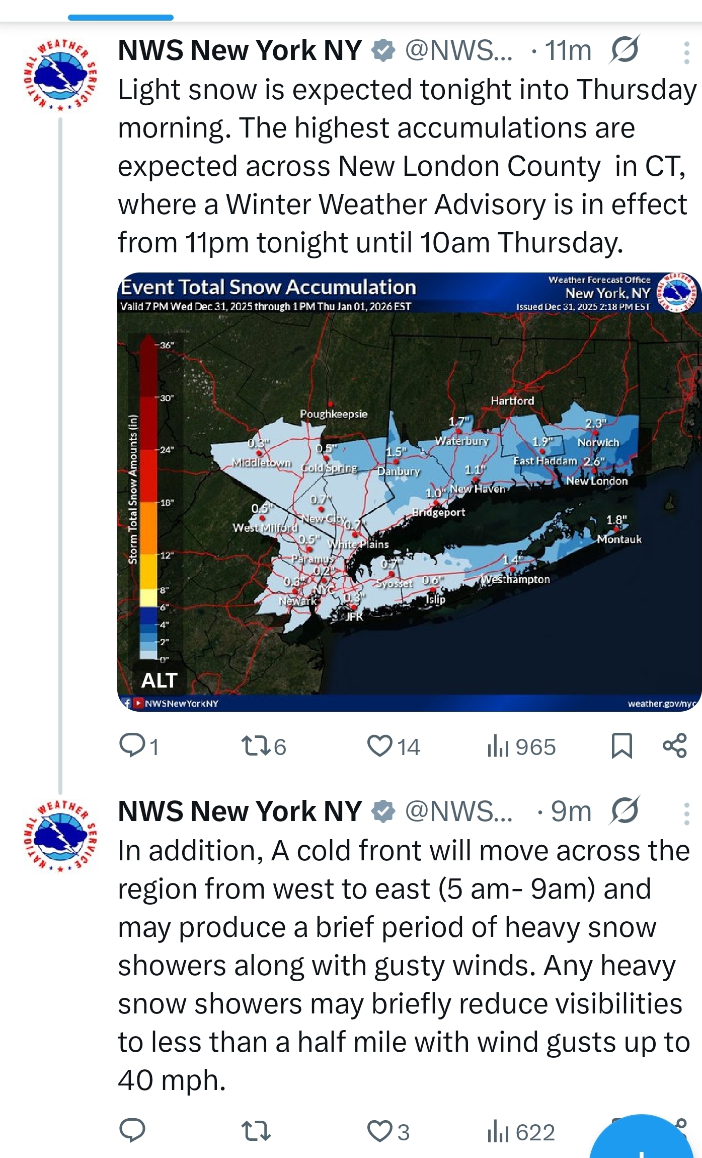
New Years Day 2026 - 1st snows of the new year possible
Baroclinic Zone replied to Baroclinic Zone's topic in New England
5am sounding off 22z HRRR centered on Taunton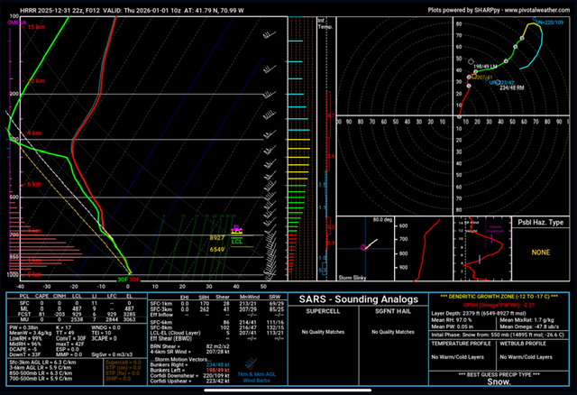
-

12/31-1/1 Possible Snow Showers/Squalls to Start 2026
nj2va replied to bncho's topic in Mid Atlantic
Snow has started -

E PA/NJ/DE Winter 2025-26 Obs/Discussion
RedSky replied to LVblizzard's topic in Philadelphia Region
Morning squall still on guidance between 5-6am -
The NWS radars work well for something like 60+ miles with the low altitude snow, including lake effect snow. Then, I think they overshoot the clouds and snowflakes. You can see it all over the region. It's pretty commonly a problem with detecting lake effect snow. Also, areas in the vicinity of Findlay have the least accurate tornado warnings, given the fact that tornado warnings mainly come from radar. That's bad, but worse radar holes for severe weather exist in the plains such as east of Dallas.
-

January 2026 regional war/obs/disco thread
Damage In Tolland replied to Baroclinic Zone's topic in New England
Certainly 1-3/2-4 every couple days are more them dustings and make it very wintry . I prefer these over swfe -
January thaw is coming early in January especially in the 6-10 day period --with the wpo negative - the epo negative the nao negative he ao going negative and the pna positive especialy after Jan. 10 chances are we will have below to well below normal temps in the east the second half of January along with the southern stream waking up. In addition another Strat Warming event is on the table for sometime next month setting the stage for a cold Feb. All of this with the MJO in the COD
-

Mid-Long Range Discussion 2026
WinstonSalemArlington replied to BooneWX's topic in Southeastern States
Mid -
Have fun! I never go out on NYE anymore- its one of those 'amateur hour' holidays. Staying home, safe and partying with some friends, making some good food, tonight featuring shrimp prepared multiple ways.
-

January 2026 regional war/obs/disco thread
weathafella replied to Baroclinic Zone's topic in New England
Well we’ll probably have 1-2 cutters to mild it up but it doesn’t look prolonged or consequential. Either way outside of the cutters it’s boring. Dinkleshit snow dustings in the middle of the night don’t do it for me. -
Happy New Year to my fellow weenies. Over the years this forum has been remarkably consistent, with folks putting in the time to provide great information and analysis. It is always fun and I learn a lot. Thank you all!
-

12/31-1/1 Possible Snow Showers/Squalls to Start 2026
Eskimo Joe replied to bncho's topic in Mid Atlantic
Latest HRRR is rather emphatic for a decent snow squall tomorrow regionwide. -
January 2026 regional war/obs/disco thread
Damage In Tolland replied to Baroclinic Zone's topic in New England
As Tippy and Will alluded .. there may not be much of a mild up at all -
Precip creeping northward each run. Problem is the temps are very marginal. The crappy pacific is winning over the NA, AS MODELED on the GFS/GEFS. We shall see.
-
Could work.
-

Pittsburgh/Western PA WINTER ‘25/‘26
TimB replied to Burghblizz's topic in Upstate New York/Pennsylvania
Tonight’s event starting to look a little meh? NWS keeps lowering amounts. -
January 2026 regional war/obs/disco thread
weathafella replied to Baroclinic Zone's topic in New England
Gefs and geps concur with each other while the euro is a bit different in the long range. Either way, all have a cold reload quickly. I sure hope something comes out of the sky. Boring as hell right now. -
Id rather live in Worcester MA or somewhere in SNE with elevation because of the nor’easters. LES is cool but nothing beats the a good ol’ fashioned 20-30” coastal .
-

January 2026 regional war/obs/disco thread
moneypitmike replied to Baroclinic Zone's topic in New England
Good news/bad news Feeling a little like Phillip Rivers as I've been called out retirement. On the other hand, this requires me to be holding on to Pit 2 for at least a couple more years. Maine winters and Mattapoisett summers--things could be worse. Now that I think of it, if things play out well for Mattapoisett tonight, we might be getting close to Ray. j/k -
Works for me I’m sitting in central Delaware County only 30 minutes NE of Elkton Md. Cliff jump here no because we already had an amazing 6.5” postcard snow back on December 14th. My expectations for the amazing pattern and over hyped pattern on the models for 3 days was kept low, so come what may. Maybe I can get a snow squall between 4 am to 8 am tomorrow morning.
-
@stormtrackerwhat’s your ETA
-

-
You need to understand that lake effect is totally different between northwest Pa. and Phillidelphia. This is 2 totally different worlds!!!!!!!! Dear God! I thought your knowledge was advanced...................................
-

New Years Day 2026 - 1st snows of the new year possible
BrianW replied to Baroclinic Zone's topic in New England

-

January 2026 regional war/obs/disco thread
Go Kart Mozart replied to Baroclinic Zone's topic in New England
His constant inhaling of snot was annoying.